 |
| ROCK SOUNDS OF JERUSALEM |
|
The figures show heights of rocks from the sea level. a. The author's idea of the course of the
Tyropeon Valley. b. The author's idea of the general direction of the second north wall. |
| Page 144. |
|
[Table of Contents] [Previous] [Next] |
J. W. McGarvey Lands of the Bible (1881) |
PART SECOND.
THE TOPOGRAPHY OF PALESTINE.
C H A P T E R I.
JERUSALEM.
§ I.
THE ORIGINAL CITY.
THE city of Jerusalem is supposed to be first mentioned in the Bible under the name Salem. If this supposition is correct, it was the residence of Melchizedec.1 From the time of Abraham's interview with this mysterious personage it is not mentioned again until after the invasion of the country by the Children of Israel under Joshua, a period of about four hundred and sixty years, when it is found in the possession of a Canaanitish tribe called Jebusites. At this period, and for a considerable time after, it was known under the name of Jebusi or Jebus.2 There can be no doubt that this name was derived from that of Jebus, the ancestor of the Jebusites, who then inhabited the city.
The origin of the name Jerusalem has been the subject of several different theories, the most plausible of which is that it is a combination of the preceding names Jebus and Salem, the b in Jebus being changed for euphony to r, thus forming the compound word Jerusalem.3
The author of the book of Joshua states that the children of Judah could not drive out the inhabitants of Jerusalem, "but the Jebusites [143] dwell with the children of Judah at Jerusalem unto this day."4 Yet the author of Judges, in recapitulating the conquests under Joshua, says that "the children of Judah had fought against Jerusalem, and had taken it and smitten it with the edge of the sword, and set the city on fire."5 We gather as the result of these two statements that the city was at one time captured, but that the Jebusites retook it and then held it permanently, living in it at peace with the adjacent tribe of Judah. It should also be observed that the city lay within the territory assigned to Benjamin, the line passing through the Valley of Hinnom immediately south of it. It is probable that Judah's first attack on it was made previous to the assignment of Benjamin's lot, and while it was yet considered within the territory of Judah.6
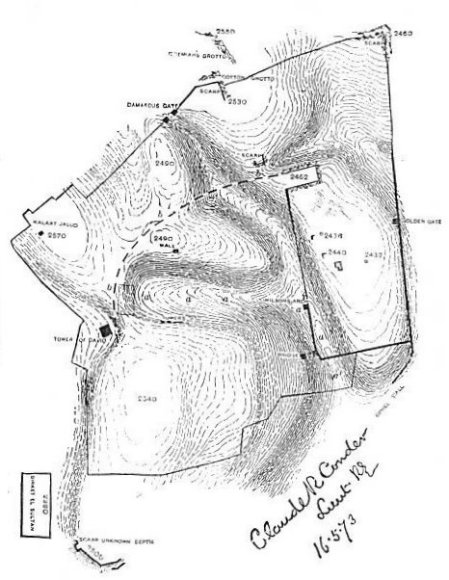
Jerusalem remained in possession of the Jebusites during the entire period of the Judges, through the reign of Saul, and until the eighth year of the reign of David, when it was captured and made the capital of David's kingdom. The fact that it had been successfully held by a handful of Jebusites in the very heart of the land of Israel for more than five hundred years7 was manifest proof of its superior military strength, and justified its choice as a capital. An occasional reference to the opposite cut from a draft by Conder, representing the actual lay of the rock of the entire city, will help the reader to understand the description which follows.
At this time, as is evident from the statements of the sacred text,8 the city was confined to the summit of Mount Zion, and the stronghold of its defenses was a fortification called Millo. The theory of some modern scholars, headed by Mr. Ferguson, that Mount Zion, the city of David, was on the southern end of Moriah, has been disproved by Warren and Conder.
This mountain was completely isolated by surrounding ravines, except at its northwest corner, where a narrow saddle of rock connected it with higher ground lying off in that direction. On the top of that saddle the modern Joppa gate now stands. Outside of this gate to the southwest, and within fifty yards of it, the Valley of Gihon, which heads about half a mile due west of this point, makes an abrupt turn to the south and passes--deepening rapidly as it goes--along the western side of Mount Zion. Thence, by an abrupt turn to the east, it passes along the southern side of the mount as far as its southeastern extremity. Its present surface is some 40 or 50 feet below the city wall [144]
|
| ROCK SOUNDS OF JERUSALEM |
|
The figures show heights of rocks from the sea level. a. The author's idea of the course of the
Tyropeon Valley. b. The author's idea of the general direction of the second north wall. |
| Page 144. |
opposite the Joppa gate, about 120 feet below the top of the mountain at the southwestern curve, and about 154 feet at the southeastern curve. Originally it was still deeper, for it has been filled up to a considerable depth, stone walls having been built across it at short intervals to cause an accumulation of soil. All of that portion of it south of Mount Zion is called the Valley of Hinnom.
The present Joppa gate is on the western slope of the connecting saddle mentioned above, the exact water-shed of the rock of this saddle, according to Conder's excavations, being about 70 yards east of this gate. From this water-shed a valley runs due east along the northern base of Mount Zion, growing deeper and narrower as it advances. It curves abruptly to the south around the northeastern corner of the mount, and thence runs almost due south until it joins the Valley of Hinnom. This valley is called the Tyropeon. The separating saddle, from which it takes its descent, is 40 feet below the top of Mount Zion, and the valley, as it passes along the northern side of this mount, has a depth to the rock of more than 100 feet; but now it is filled up in places with rubbish to a depth of 40 feet. At the northeastern curve it is 150 feet below the top of Zion, and midway the eastern side of Zion it attains a depth of 290 feet. These figures are based upon the rock-levels ascertained by the excavations of Captain Warren,9 and they show that from the very nature of the ground on which the original Jerusalem stood it could be approached only by a steep ascent on every side, except along the top of the narrow ridge at the northwest, and that the top of this ridge was 40 feet below the highest ground within the city. The chief fortification, called Millo, must have been located here, and here at the present day stands its successor, the fortification called the Tower of David. Properly defended at this point, the city was impregnable against any ordinary attacking force; and it is not surprising that when David came near to assault it the Jebusites taunted him with the remark, "Except thou take away the blind and the lame, thou shalt not come in hither: thinking, David cannot come in hither."10
Josephus, in his account of David's capture of Jerusalem, speaks of a lower city which he took before he assaulted the citadel.11 Dr. Barclay supposes this to be Salem. But there is no Scripture authority for this, and it is unreasonable in itself: for why should the city be built on low ground in front of the citadel, fully exposed to attack, when there was unassailable ground behind the citadel, with the latter for a [145] protection at its only weak point? It was a military necessity to build the city on the top of Zion.
As the city was when David took it, such it continued to be throughout his reign, with the exception of internal improvements and the strengthening of its fortifications.12 This, therefore, is the city which we must have in mind when we are considering its history during the reign of David, and the allusions to it made in the Psalms of David,--for example, the exulting strains of the forty-eighth psalm:
| "Great is the Lord and greatly to be praised
In the city of our God, in the mountain of His holiness. Beautiful for situation, the joy of the whole earth, Is Mount Zion on the sides of the North, The city of the great King. * * * * * * * Walk about Zion, and go round about her: Tell the towers thereof. Mark ye well her bulwarks, consider her palaces; That ye may tell it to the generation following." |
§ II.
THE CITY UNDER SOLOMON.
The site selected for the Temple of Solomon, we are told, was "in Mount Moriah, where the Lord appeared to David, his father, in the place that David had prepared in the threshing-floor of Ornan [or Araunah] the Jebusite."13
Mount Moriah was a long, straight ridge, running north and south, a short distance northeast of Mount Zion. From one extremity to the other it was more than a mile in length, while its width was less than a quarter of a mile at the widest part. It terminated towards the south in a long slope, narrowing as it descended, and reaching a level near the point of junction between the Valley of Hinnom and the Tyropeon Valley. The latter valley separated this southern slope from Mount Zion, and the northern end of Zion was due west from the highest part of Mount Moriah. Much the greater part of Mount Moriah lay farther north than this. As we stated in the last section, the descent from the summit of Mount Zion to its northeastern foot in the Tyropeon Valley was 150 feet, but the ascent thence to the top of Moriah was only 50 feet, the latter mountain being 100 feet lower than the former. The elevation of the two above the sea is [146] respectively 2540 feet and 2440 feet. But the Tyropeon Valley deepens very rapidly as it passes southward, and at the southern extremity of the temple inclosure it has a depth of 150 feet below the summit of Moriah, measuring down to the rock.
It thus appears that when Solomon prepared to build his temple Mount Moriah was entirely outside of Jerusalem; that it was separated from it by a deep, narrow ravine; and that its summit, where the temple was to stand, was due east of the northern part of the city. It had been the wheat-field of Araunah, the Jebusite. David had allowed him to retain it after he had taken the city, but had purchased it from him at the time of the plague.14 The eastern side of Mount Moriah was a steep slope descending into another deep and narrow ravine, called sometimes the Valley of Jehoshaphat, and sometimes the Valley of the Kedron. The bed of this valley descends but little more rapidly than the slope of the mountain, and its average depth may be stated at 240 feet below the top of the ridge of Mount Moriah.
On the very summit of Mount Moriah Solomon built his temple, laying the foundations, of course, on the solid rock, and including in them the threshing-floor on which David had made his offering. Around it he made an inner court, inclosed by a wall, and outside of this a greater court.15 But the summit of the mountain, being a sharp ridge, did not furnish a level space of sufficient extent for these courts, and hence the necessity of the work which constituted the chief part of his undertaking, demanding the labor of the vast army of workmen for a period of seven years.16 Of this work Josephus gives a brief and characteristic description. After speaking of the temple proper and the inclosure of the inner or Jewish court, he says: "But he made that temple which was beyond this,--a wonderful one indeed, and such as exceeds all description in words; nay, if I may so say, is hardly believed upon sight; for when he had filled up great valleys with earth which, on account of their great depth, could not be looked on when you bended down to see them without pain, and had elevated the ground four hundred cubits, he made it to be on a level with the top of the mountain on which the temple was built, and by this means the outmost temple, which was exposed to the air, was even with the temple itself."17
This rude and inaccurate description is readily understood, and its inaccuracies corrected, in the light of recent excavations. No doubt [147] Josephus formed his conception of the work from the appearance of the temple mount in his own day; and many modern observers have drawn conclusions from its appearance not less inaccurate than his. Nothing but actual excavations to the natural rock of the mountain and its adjacent valleys could determine what Solomon's work really was; and previous to these excavations many conclusions of the utmost importance could be reached only by conjecture. But during the year 1867 excavations were made by Captain Warren, under the auspices of the Palestine Exploration Fund of Great Britain, to the foundations of the present wall around the site of the temple, and to the solid rock in many other places about this mountain. It was ascertained that most of the present outer wall of the temple inclosure was founded by Solomon, the lowest layers of the rock being now precisely where he laid them. We are able, therefore, to state in most particulars proximately, and in some precisely, what work of Solomon Josephus describes so obscurely in the above extract. It was as follows:
Wishing to make a broad level area on top of the mountain and nearly on a level with its sharp summit, he laid the foundations of the eastern and western walls on the solid rock near the foot of the mountain on each side, and built them up perpendicular until their tops were on a level with the top of the mountain. This required the western wall to be 150 feet high at its southern end, and 80 feet high just opposite the temple. The eastern wall was 170 feet high at its southern extremity, and 70 feet opposite the temple; but on account of descent of the rock from this point northward it was 160 feet high near its northern end,18 where it crosses a depression in the rock. It is 1536 feet long, while the western wall is 1608.
To connect the southern ends of these two walls, which were 927 feet apart, a cut was made across that part of the mountain which lay between them, and the solid rock laid bare to receive the foundations of the southern wall. The rock here rises about 100 feet as we pass from the east side westward, and then descends about 80 feet ere we reach the southwestern corner. This wall, then, in order to reach the level of the mountain's top, was built up like the southern end of the eastern wall, with which it made an angle, 170 feet high; at the highest part of the rock towards the west it was 70 feet high, and at the southwestern angle 150 feet. Everywhere, as Captain Warren discovered, [148] the foundation stones were laid not only on the natural rock, but within a bed 24 inches deep cut for them into this rock, so that nothing could move them from their places. The foundation stones in many places bear to this day the marks of Phœnician letters painted on them by Hiram's workman, to show the order in which they were to be laid down.19 Many of these stones are of enormous size. Captain Warren reports one in the southeast angle whose estimated weight is 100 tons,
 |
| SUBSTRUCTIONS AT THE SOUTHEAST CORNER
OF THE HAR'AM. |
The two side walls are not parallel, but they diverge toward the north, so that, although only 927 feet apart at the southern end, they are 1044 feet apart at the northern end. At the northwestern angle the natural rock came to the surface, and rose 20 feet above the level that was desired: so here the rock was cut away in leveling, and a perpendicular wall of it 20 feet high was left at the corner, and for some distance east of it. The western wall terminated against this natural rock, and the northern wall, starting from it eastward, closed up the remainder of the northern end. This rock formed a narrow neck connecting this part of Mount Moriah with that part which extended farther north, and on this, in Herod's time, stood the fortification called the Tower of Antonia.
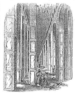
When Solomon had erected these walls, his next task was to level the inclosed space, amounting to thirty-five acres, so as to bring the low slopes next to the walls up to the height of the space about the [149] temple, or nearly so. He left the court immediately about the temple higher than the surrounding area, but doubtless only a few feet higher. The filling in necessary for the purpose of this leveling, is estimated by Captain Warren at not less than 70,000,000 of cubic feet. To save the necessity of filling this space solidly, a large number of stone piers were built at the southeastern angle, where was the greatest open space, nearly to the desired height. Vaults of masonry were turned on top of these, and earth laid on top of the vaults. These, when first discovered in modern times, were called Solomon's Stables, in ignorance of their true design.20 They are seen in the preceding cut.
When the space within the walls was thus leveled, or reduced sufficiently near to a level to suit Solomon's purposes, the walls were doubtless carried up still higher all around, and a parapet constructed on top of them; so that they served the additional purpose of a military defense to the temple. As such they presented, on the eastern side, a perpendicular front, averaging more than 150 feet, with a steep approach to the foot of the wall from the narrow floor of the Kedron Valley. Opposite the southeast angle this valley was 100 feet lower than the foundation of the wall and very close to it. The entire height of the wall at this angle above the valley below must have been not less than 280 feet. The earth outside the wall at this point, as Captain Warren discovered by his excavations, was only 8 feet deep; for in digging here he passed through débris until within 8 feet of the rock, when he struck the original natural soil. The exposed part of the wall then, outside, was about 172 feet high, supposing it to have been built 10 feet higher than the summit of the mountain, while the exposed part inside was only 10 feet. Thus was the mountain cased in with a stone wall, and changed from a sharp ridge to a vast mound, with a level summit of thirty-five acres containing the temple and its courts. Only at the northwestern corner of the inclosed space was it approachable on level ground, and in this respect it was precisely like Mount Zion. What extra defense was built here the Scriptures do not inform us; probably nothing more than a suitable strengthening of the wall by towers and buttresses.
This temple-crowned and stone-encased mountain was next connected with the previously existing city on Mount Zion by running two walls across the intervening valley, one from the northern curve of Mount Zion, and the other from such a point along the eastern side of the same as to connect it most conveniently with the southern end [150] of the temple inclosure. No trace has been found of the foundations of these walls, but the remains of two bridges that once spanned the valley and furnished passages from one mountain to the other have been discovered. The more southern of these, 39 feet from the angle, is called Robinson's arch, from the name of its modern discoverer, Dr. Edward Robinson; and the more northern Wilson's arch, from the name of its discoverer, Captain Wilson, of the Palestine Exploration Fund. It is believed that both of these arches were built by Herod; but beneath them are the remains of older ones, which are supposed to have been the work of Solomon.21
Many modern reconstructors of ancient Jerusalem have located Solomon's palace at the southern end of the temple inclosure, and most of these have supposed that it occupied the southeast angle; but they seem to have strangely overlooked the fact that, if thus situated, it must have been built on the tall columns erected there for the purpose of leveling up the surface, and the erection of a large and massive palace on such supports is unheard of in the history of architecture. The author cannot resist the conclusion advocated by Captain Warren, against the almost unanimous voice of recent explorers, that this palace stood on the loftier hill of Zion.22 As Warren is the most thorough and exhaustive explorer who has ever worked on the topography of Jerusalem, his opinion is entitled to the highest degree of respect.
§ III.
JERUSALEM: ADDITIONS BY THE SUCCESSORS OF SOLOMON.
When Solomon's work on Jerusalem was completed, the city walls included, as we have seen in the previous section, Mount Zion, a small portion of Mount Moriah, and so much of the Tyropeon Valley as lay between these two. The southern continuation of Mount Moriah, often mentioned under the name Ophel, a long tongue-like slope terminating at the junction of the Tyropeon and Kedron Valleys, was left outside the walls. All of the same mount which lay north of the northern wall of the temple court was also left outside, but a broad ditch in the solid rock, which is still visible, was cut across it to prevent an easy approach from that direction. At that time the northern wall of Mount Zion overlooked the upper part of the Tyropeon Valley, while another valley nearly at a right angle to this extended northward along the entire [151] western base of Mount Moriah. In the angle between these two valleys arose a knoll whose rock-summit is 2490 feet above the sea level, just 50 feet lower than the summit of Mount Zion. See the cut of the rock-soundings, page 144. All of this was then outside of the city. But a second wall, beginning at the northwest corner of Zion, and heading the Tyropeon Valley, inclosed this knoll, and passing thence across the other valley terminated at the northwestern corner of the temple wall. Josephus calls the part thus inclosed the lower city, from the fact that it was all lower than Mount Zion; and he says that "it is of the shape of the moon when she is horned," by which he evidently means that its outward limit was an arc of a circle. It is possible that this wall was built by Solomon, and that it is included in the Scripture statement that he built "the wall of Jerusalem round about;"23 but we have no specific ground on which to ascribe the work to him, and we have as little for ascribing it to any one of his successors. The next statement which we find in the Scriptures concerning the building of walls is in 2 Chronicles xxvi. 9, where it is said that "Uzziah built towers in Jerusalem, at the corner gate, and at the valley gate, and at the turning of the wall, and fortified them." This appears to be a strengthening of existing walls by additional means of defense, but not the erection of new walls.
In the reign of Jotham, the successor of Uzziah, there seems to have been a wall upon Ophel, the southern extremity of Mount Moriah; for it is said of Jotham that "He built the high gate of the house of the Lord, and upon the wall of Ophel he built much."24 Of the extent of this wall we know nothing.
Hezekiah found it necessary to again repair the walls of the city, and he built a new wall of whose position and extent we know nothing. We have only the brief statement that "he built up the wall that was broken, and raised it up to the towers, and another wall without, and repaired Millo in the city of David."25
To Manasseh, the son and successor of Hezekiah, is ascribed the complete inclosure of Ophel: "He built a wall without the city of David, on the west side of Gihon in the valley, and compassed about Ophel, and raised it up a very great height."26 The clauses, "without the city of David" and "on the west side of Gihon in the valley," locate that part of this wall which reached from the wall of the city of David, or Mount Zion, across to Ophel. Gihon is the name by which the [152] Tyropeon Valley was then known. This wall was "in the valley" because it extended across the valley, and it was "on the west of Gihon" in the sense that most of it was on the west side, the deepest part of the valley here lying close under the precipice of Ophel. Many modern writers on Jerusalem have doubted the existence of a wall around Ophel, and they gave this passage a different interpretation, until Captain Warren actually found a large portion of it during his excavations, and traced its course from the southeastern angle of the temple-wall about 700 feet south, where it terminated within a few feet of the surface. It is 14 feet thick, and, though entirely under ground, it is from 40 to 60 feet high.27
We have no account of other additions to the city previous to the Babylonian captivity. We suppose that no others were made, and that consequently the city of Jerusalem, during the period of the kings of Judah, attained to no greater dimensions than those which we have given above. In other words, the city, in its greatest extent during this period, included no more than Mount Zion, Mount Moriah as far north as the temple-court extended, the valley between these two, and the comparatively low ground lying in the angle north of the former and west of the latter.
When Nehemiah re-erected the walls, after the return of the Jews from Babylon, he built on the old foundations, and the former dimensions of the city seem to have been restored.28 From that time till the time of Christ only two alterations are known to have been made in its topography. Josephus represents the Asmonean princes29 as having cut down the top of the knoll in the lower city called Akra, and filled up the Tyropeon Valley.30 This was a change in the level of the northern part of the city. The other change was made by Herod. He reconstructed the temple and its surrounding walls, and built a fortification at the northwest corner of its outer court, which he named Antonia in honor of Mark Antony. He also built a number of towers in the walls of Zion and Akra. These changes left the general outline of the city about as it was before the captivity, and consequently the Jerusalem of the gospel narratives was nearly identical in extent with the Jerusalem of the later kings and prophets. [153]
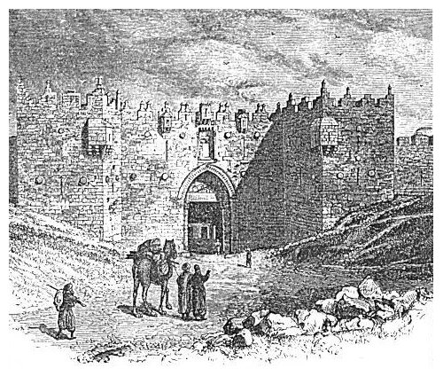
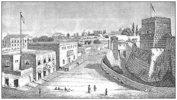
The most important addition made to the city after the time of Solomon, and the one which brought it to the greatest extent it ever attained, was begun by Agrippa (the Herod of Acts xii.) and afterwards completed by the Jews. It is commonly called the third wall, the second being the semicircular one inclosing Akra, and the first the original wall around Mount Zion. The only account of this wall which has come down to us is given by Josephus. He represents it as starting from the Tower of Hippicus, supposed to be identical with the present Tower of David (see the cut on the opposite page), adjoining the Joppa gate; thence it ran north as far as the most northern part of the city; thence it passed somewhat east of north until it came "over against the monuments of Helena" (a locality not certainly identified); thence it extended to "the Tower of the Corner," which must be the northeastern angle of the wall; and thence it ran southward along the eastern declivity of Mount Moriah, overlooking the Kedron Valley, until it united with the northeastern wall of the temple inclosure, which had previously been the northeastern corner of the city. This wall inclosed additional space along the western and northern sides of Akra, which had been called the lower city. The northwestern part of the ground thus inclosed was higher than the summit of Mount Zion. It has an elevation of 2570 feet, according to Conder, while that of Mount Zion is 2540 feet.31 It also inclosed the northern extension of Mount Moriah, which Josephus says was then called Beze'tha, the New City. This historian states the occasion of constructing this wall in these words: "As the city grew more populous it gradually crept beyond its old limits, and those parts of it which stood north of the temple and joined that hill to the city made it considerably larger, and occasioned that hill, which is in number the fourth, to be inhabited also." His account of the cessation of Agrippa's work on the wall, and of its subsequent completion, is as follows: "He left off building it after he had only laid the foundations, out of the fear he was in of Claudius Cæsar, lest he should suspect that so strong a wall was built in order to make some innovation in public affairs; for the city could in no way have been taken if that wall had been finished in the manner it was begun. As its parts were connected together by stones twenty cubits long and ten cubits broad, which could never have been either easily undermined by any iron tools or shaken by any engines. . . . After this it was erected with great diligence by the Jews as high as twenty cubits, above which it had battlements of two cubits [154]
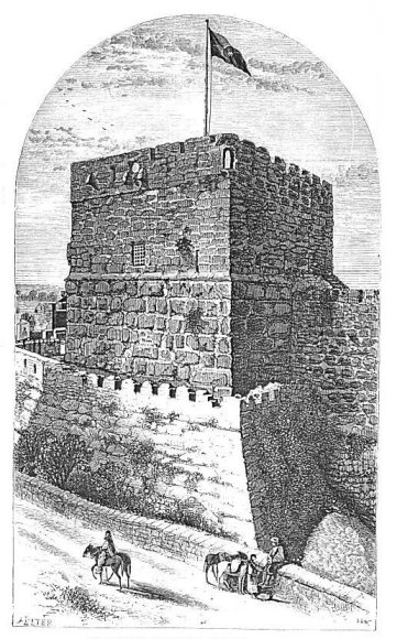 |
| THE TOWER OF DAVID,--NORTHERN SIDE. |
| Page 154. |
and turrets of three cubits altitude, insomuch that the altitude extended as far as twenty-five cubits."32
The death of Agrippa occurred in the year 44 of our era, just ten years after the death of Jesus, and twenty-six years before the destruction of Jerusalem by Titus; consequently, this enlargement of the city to the greatest dimensions which it ever attained occurred subsequent to the solemn announcement of its doom which had been made by Jesus.33 Though that doom was to befall it, according to the prediction, before the generation then living should pass away,34 when ten years had passed the city had started on a new career of growth and apparent prosperity, yet the words of Jesus were not falsified by the result.
§ IV.
JERUSALEM: ITS DESTRUCTION BY TITUS AND ITS LATER HISTORY.
Jerusalem was taken by Titus in the year 70 of our era after a desperate war and a bloody siege. It is asserted by Josephus that during this war 97,000 Jews were carried into captivity, and that the number of those who perished in the city was 1,100,000. He does not claim that the population of the city was equal to this last sum, but that so many were assembled there at the Passover feast when the siege was begun, and were shut up within the city by the approach of the Roman army.35 His account of the destruction of the city at the close of the siege is given in the following words:
"Now as soon as the army had no more people to slay or to plunder, because there remained none to be the objects of their fury (for they would not have spared any had there remained any other such work to be done), Cæsar gave orders that they should now demolish the entire city and temple, but should leave as many of the towers standing as were of the greatest eminency, that is, Phasaelus, and Hippicus, and Mariamne, and so much of the wall as inclosed the city on the west side. This wall was spared in order to afford a camp for such as were to lie in garrison, as were the towers also spared in order to demonstrate to posterity what kind of a city it was, and how well fortified, which the Roman valor had subdued; but for all the rest of the wall it was so thoroughly laid even with the ground, by those who dug it up to the foundation, that there was left nothing to make those that came hither believe it ever had been inhabited."36 [155]
Such was the close of Jerusalem's history as a Jewish city. It fell with the downfall and dispersion of the nation. A very brief synopsis of its subsequent history is given in Smith's Bible Dictionary (Art. Jerusalem), from which we glean the following facts. For more than fifty years after its destruction by Titus Jerusalem disappears from history. Of its annals during this period we know nothing. But in A. D. 132, under the Emperor Hadrian, the Jews then in Palestine concocted a secret revolt, made one Bar Co'chebas their leader, crowned him as a king, took possession of the ruins of Jerusalem, and undertook to rebuild the temple. They maintained themselves against the Roman army, which was sent to subdue them, for two years, when the city was taken, and Bar Co'chebas was killed. Other fighting of a most desperate character followed, in which there was frightful slaughter on both sides; but the Jews who escaped the slaughter were totally dispersed. Under Hadrian's orders the ruins of the city which Titus had left standing were razed, the site of the temple was ploughed over,37 a temple to Jupiter was built on a portion of it, and a statue of the emperor was erected where the Holy of Holies had been. A Roman colony was planted in the city, and its name was changed to Aelia Capitolina, a name which it continued to bear for several centuries, and Jupiter was proclaimed its guardian deity. Jews were forbidden to enter the city under pain of death, and this prohibition continued in force for about 200 years; but about the middle of the fourth century they were allowed to enter it once a year, and weep over it on the anniversary of its capture. Jerome represents them in his day as being accustomed thus to weep by the west wall of the temple, and says: "On the ninth of the month Ab might be seen the aged and the decrepit of both sexes, with tattered garments and disheveled hair, who met to weep over the downfall of Jerusalem, and purchased permission of the soldiery to prolong their lamentations."
After the changes effected by Hadrian, but little is known of the city until the fourth century, except that it became to some extent a Christian city, and that a list of twenty-three bishops who resided there is preserved.38 In A. D. 326, the Empress Helena, mother of Constantine, visited Jerusalem and built a church on the Mount of Olives to commemorate the ascension of Christ, and one in Bethlehem over the supposed site of the Saviour's birth. Her son, the emperor, [156] followed her example by building a chapel over the supposed site of the Holy Sepulchre.
In the year 362, the Emperor Julian, commonly called the apostate, was moved by his hatred of Christianity to attempt the reconstruction of the Jewish temple and the restoration of its ancient worship. Materials were furnished at his expense, and many of the Jews entered upon the work with great enthusiasm; but while they were clearing away the rubbish and preparing for the foundations of the new temple balls of fire issued from under the ruins and frightened the workmen away. Many exaggerated accounts of this incident were given by Christian writers of the period, but the principal fact is asserted in the writings of Ammianus Marcellinus, a friend and companion in arms of the emperor, and it must be credited.39 The occurrence was universally ascribed at the time to supernatural agency, but it may have been the result of the explosion of gases which had accumulated in openings amid the ruins, and which exploded as the air was let in by the tools of the workmen.
In the year 529 the Greek emperor Justinian built in Jerusalem a church in honor of the Virgin Mary, and also established a number of monasteries in the neighborhood of Jerusalem and Jericho. The country had then been for two hundred years the resort of many pilgrims, and monks and hermits had been for a long time swarming to its sacred localities in great numbers. This state of affairs was interrupted early in the next century by the results of a war between the Emperor Heraclius and the Persians under Chosro'es II. The Persian army invaded Palestine in 614, and, assisted by many Jews, took Jerusalem by assault, slew many of the monks and clergy, demolished all the churches, and burned much of the city. The war lasted for fourteen years, and finally resulted in a victory over the Persians and the restoration of Jerusalem; but the triumph was of short duration, for in 637, only nine years later, the city was surrendered to the Calif Omar and entered upon its history as a Mohammedan city. It was stipulated as one condition of the surrender that the Christian population should be still permitted to worship in their existing churches, but that no more churches should be built. This liberty has been continued with but little interruption until the present day. Omar removed the dirt and [157] filth which had accumulated on the site of the temple, assisting in the work with his own hands, and built thereon a wooden place of prayer. In the year 688, only fifty-one years after the surrender to Omar, the Calif Abd-el-Melek replaced this wooden structure by the splendid building which now occupies the spot, improperly called the Mosque of Omar.40 This last fact is attested by an inscription in the building itself.41
The next important epoch in the history of the city is its capture by the Crusaders in the year 1099. It was then made the seat of a Christian kingdom, and continued so until after the fatal battle of Hattîn, near Tiberias, in July, 1187, in which the celebrated Saladin broke the power of the Christian kingdom and again restored Jerusalem to Mohammedan dominion. Within the next fifty years it fell twice more into the hands of Christians, only to be speedily lost, and finally, in 1244, the efforts of the Crusaders were abandoned, and Palestine remained a dependency of the caliphate of Egypt.
In the year 1517, Selim I., sultan of the Ottoman empire, took possession of the country, and his successor, Suleiman, built the present walls of Jerusalem, A. D. 1542. With the exception of eight years, from 1832 to 1840, during which it was once more held by Egypt, under Mohammed Al'i, it has remained under the dominion of the Turkish sultan until the present time, a period of three hundred and sixty-three years.
§ V.
JERUSALEM: ITS PRESENT WALLS, HILLS, AND VALLEYS.
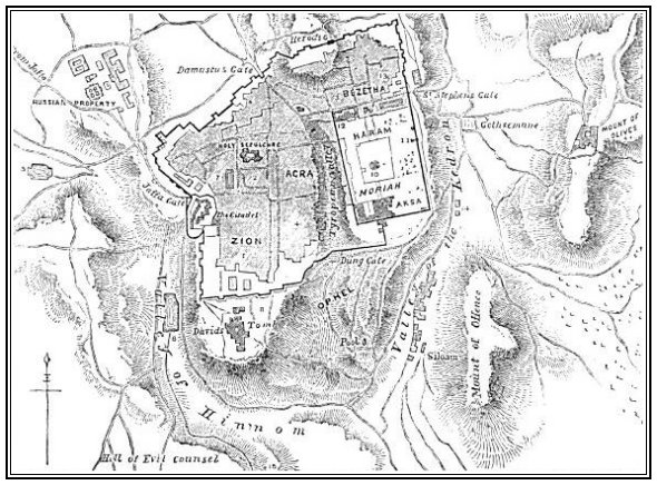
In studying the remainder of our description of Jerusalem, it would be well for the reader to make frequent references to the plan of the city on the opposite page.
The only gate now on the western side of Jerusalem is the one called by the Arabs Bab-el-Kulîl (the Gate of the Friend). An inscription cut in Arabic characters into a marble slab over the entrance sufficiently points out the "friend" referred to in the name. It is this: "There is no god but God, and Abraham is the friend of God." This gate is chiefly known to Europeans as the Joppa42 gate, because through it the road to Joppa enters the city. But it is sometimes called the "Bethlehem Gate," because the road to Bethlehem, which [158]
 |
| PLAN OF JERUSALEM. |
|
1. Armenian Quarter.
2. Christian Quarter.
3. Mohammedan Quarter.
4. Jewish Quarter.
5. Upper Gihon.
6. Lower Gihon. 7. Pool of Hezekiah. 8. Zion Gate. 9. Bethesda. 10. Dome of the Rock. 11. Golden Gate. 12. Tower of Antonia. 13. Church of Pater Noster. 14. Absalom's Tomb. 15. Aceldama. 16. Joab's Well. |
| Page 158. |
approaches it from the southwest, also enters through it. Much more than half the travel and traffic of the entire city at the present time passes through this gate; consequently, it is the best point from which to start in attempting to give the reader a general conception of the city.
 |
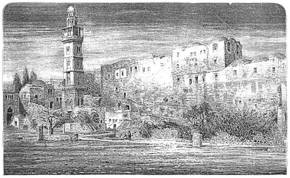
| THE DAMASCUS GATE. |
From the Joppa gate the wall runs almost due northwest about 1300 feet, where it reaches the northwest corner of the city. Here stood an old castle called Kalât el Jalûd (the Castle of Goliath); but in the year 1878 its ruins were entirely demolished, and the ground is now occupied by a large and handsome two-story school-building belonging to the Franciscan monks, and by the garden and playground attached to this building. The natural rock on which the wall stands rises at this corner several feet above the outside surface, and the inner surface here is the highest part of the city.
From the northwest corner of the city the distance along the northern wall to the Damascus gate is nearly 600 yards, in a waving line. The direction is about east northeast, and there is a descent of [159] about 50 feet, so that when you stand on top of the wall over that gate, which is 50 feet high, you are about on a level with the foundation of the wall back at the northwest corner. This is the most elaborately constructed of all the present gates, and it is defended by two towers, which are seen in the preceding cut. Passing along the top of the wall from this gate in the same general direction, but a little nearer east, at a distance of 375 yards farther we come to a gate now closed up, called Herod's gate. In passing this distance we have crossed over another rise in the ground, which is nearly as high as the northwest corner; and here the natural rock shows itself at least 25 feet above the outside surface, forming a perpendicular ledge, on the top of which the wall is built. Standing here and looking back, we can very plainly see that we have crossed a valley, and that the Damascus gate is in the lowest part of it. Then turning and looking toward the northeast corner, we see that there is a rapid descent to the Herod gate, and thence, a level to the corner. From the Herod gate to the northeast corner, bearing very little north of east, is about 330 yards. Adding together the figures now given along the northern wall, we find the distance about 1300 yards, nearly three-quarters of a mile. This is the longest side of the city.
The eastern wall is 921 yards or a little more than half a mile in length, and its course is nearly due north and south. From the northeast corner south to St. Stephen's gate, the only gate now in use on this side, is about 341 yards, and the descent is probably 40 feet. Thence to the corner of the har'am or temple inclosure, is about 67 yards, and the entire length of the eastern wall of the har'am is 512 yards. This wall overlooks the Valley of the Kedron all the way, and it maintains a gradual descent through its entire length, though the steepest descent is from the northern end of it down to St. Stephen's gate.
The wall on the south side of the city is very crooked. Starting from the southeast corner of the har'am, the wall of this inclosure is the outer wall of the city for about 238 yards westward, where the city wall starts out at a right angle, and runs by a rapid descent down the slope of Ophel southward for 98 yards. Thence making another right angle, it runs west 171 yards, where it reaches a small gate commonly called the Dung gate, but called in Arabic Mugrabin or Stranger's gate. This last piece of wall crosses the Tyropeon Valley, and makes an ascent of about 50 feet up the side of Mount Zion, and the gate is on a shoulder of this mount. The wall where it crosses the valley is not over five feet above the level of the ground on the [160] inside which is here cultivated as a garden, though it is more than 30 feet above the ground on the outside. From the Dung gate the wall continues to ascend toward the southwest, making four angles of 45° alternately southward and westward, and reaches Zion gate (sometimes called David's gate) at a distance of about 320 yards. This gate is on the highest part of Mount Zion crossed by the wall, and it is nearly 300 yards from the southwest corner of the city. The entire southern wall, from the southeast corner of the har'am to the southwest corner of the city, is 1127 yards long, or about two-thirds of a mile.
The western wall runs almost due north from its southern extremity until it reaches the ditch surrounding the citadel near the Joppa gate, a distance of nearly 300 yards. This fortification extends thence 153 yards to the Joppa gate. Consequently this gate is about 453 yards north of the southwest angle of the wall, and, as we saw in the beginning of this description, about 433 yards from the northwest angle. The entire western wall, then, is 886 yards, or about a half-mile in length, with the Joppa gate a little nearer its northern than its southern extremity. This is the shortest side of the city.
The measurements above given were taken by the author himself, and chiefly by measuring along the top of the wall. It was his aim to get the distances along the general direction of each wall, and consequently he left out the length of some portions of each which run at right angles to the general course. The whole distance around the wall, according to these figures, is about 4264 yards, or a little less than 2½ miles.43 The circuit of the city is represented by Conder at about 2¾ miles,44 and it would very nearly reach this distance if the measurement were made on the ground outside, and included all the sinuosities of the walls.
The wall varies in height from forty to fifty feet above the outside surface, but at the southeast angle of the har'am it is eighty feet. It is nine feet thick at the base; the parapet is three feet thick; and there are two places for the lines of soldiers to stand upon, each three feet wide, and one about four feet below the other.
The hills of the ancient city have undergone so little change as to be identified without the least uncertainty. About one-half of Mount Zion now lies outside of the southern wall, and the most of it is [161] cultivated in grain, thus fulfilling to the letter the prediction of Micah when he said to Judah, "Therefore shall Zion, for your sake, be ploughed like a field."45
Ak'ra, the hill north of Zion, still rises forty feet higher than the highest part of Zion, but it still slopes downward as it approaches the angle between Zion and Moriah. It also slopes downward toward the Joppa gate, and more rapidly still toward the Damascus gate. The ridge north of the temple inclosure, once an unbroken continuance of Mount Moriah, has undergone the greatest change. Where the wall crosses it between the Damascus gate and the Herod gate a cut has been made through its solid rock, so as to leave a wide space between the wall which rests on one side of the cut and the other perpendicular side, thus preventing the possibility of an approach to the wall along the crest of the ridge. This cut is about two hundred feet wide. So much of the original ridge as lies between this wall and the north wall of the har'am is now called Beze'tha, which means, as explained by Josephus, the new city.
That part of the original Mount Moriah which is inclosed by the har'am wall remains as it was in the days of Herod, with the exception of the changes effected by the frequent destruction and re-erection of its walls and the entire change of the buildings within.
The greatest change in the surface-level of the city has taken place, as would naturally be supposed, in its valleys. All of these have been to a great extent filled up. Conder estimates the present surface of David Street, along the northern foot of Mount Zion, as forty feet higher than its ancient level, and thinks that the city in general has an average elevation of thirty feet, the result of so frequently tearing down houses and building others on their ruins.46 But the greatest filling up of the Tyropeon Valley is along that part which lies between Mount Moriah and Mount Zion. Near the southwest corner of the har'am, Captain Warren found the rock sixty feet below the present surface, and a short distance from that corner, along the southern wall, where the surface maintains the same level, he found it ninety feet below. His shafts were sunk through rubbish, which was so loose and so much disposed to "run," that he was compelled to case them strongly with wood as he descended. The cut on the following page represents the shaft which he sank at the southeast angle of the har'am, and it illustrates his mode of working at other points. He was compelled to sink his shafts at a distance from the wall, and then tunnel under to examine [162]
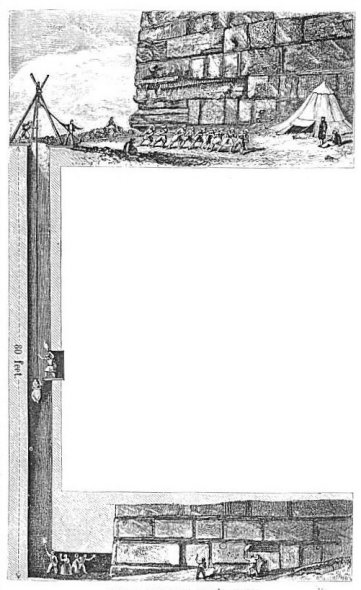 |
| ONE OF CAPTAIN WARREN'S SHAFTS. |
The same indefatigable explorer found that the Valley of the Kedron is also largely filled up. At the southeast corner of the har'am the rock was found eighty-seven feet below the present surface, and the whole of this is made earth and rubbish except eight feet of "fat-mold" next to the rock. Here there is an accumulation of about nearly eighty feet of débris from the crumbled materials of former walls. He also found the ancient bed of the Kedron, which was identified by its layer of water-worn pebbles, forty feet beneath its present surface. Moreover, the deepest part of this valley has been pushed eastward by the accumulation of rubbish from the wall until it is now ninety feet east of the original bed of the Kedron.47 The fact that this stream has long since ceased to flow except in the wettest of seasons is accounted for by the fact that this vast accumulation of loose rubbish absorbs the water as it flows from the hill-sides. This valley begins about a mile north of the city as a mere depression in the surface; [163] and when it first turns southward, northeast of the city, it is a smooth, broad valley covered with grain-fields and olive-orchards. When it reaches a point opposite the northeastern angle of the city wall it has become quite narrow, its sides are steep, and its depth beneath the wall is nearly as great as it attains at any point below, for though its bed continues to descend, the surface along the foot of the wall descends almost as rapidly. Opposite St. Stephen's gate the side of the valley is so steep that the road descending into it is cut with a zigzag, and when it reaches nearly to the bottom of the valley a further descent is saved by a stone bridge on arches thrown across to the foot of the Mount of Olives. From this bridge southward, almost to the southeast angle of the city wall, the valley has a level bed fifty yards or more in width, set with olive-trees and cultivated in grain. Walls have been built across it at intervals to check the wash and to secure an accumulation of soil. Below the southeast angle of the wall, however, the valley becomes a narrow ditch and shows marks of the rapid rush of torrents of water after heavy winter rains. Here it deepens rapidly, and near the extreme southern foot of Ophel it widens out again and makes room for luxuriant vegetable-gardens irrigated by water from the Pool of Siloam.
The Valley of Hinnom, as we have stated,48 has also undergone a considerable elevation. No excavations have been made in it, so as to ascertain the exact depth of the rock beneath the present surface, but a great part of its space is occupied by large and flourishing olive-trees, showing that the depth of the soil must be considerable. It is no longer the narrow, deep, and gloomy gorge that it once was. When the brow of Mount Zion was crowned with lofty walls, and its rocky side was bare of soil, while the bed of the valley was the naked rock now many feet beneath the surface, it was a gloomy place, and well adapted to the horrid orgies practiced there in a spot called Tophet by two of the apostate kings of Judah.49 But now nearly all that part of it which lies south of Mount Zion is from fifty to seventy-five yards wide, and has a smooth floor and a rich soil. It is preserved from being washed into gullies during the winter rains by stone walls built across it at short intervals, and it receives an annual accretion of rich soil by the wash from the heights on either side. The olive-trees spread over it a pleasant shade, but not thick enough in the spring to prevent the maturing of the grain that is grown on the well-ploughed ground. On the western side of Mount Zion, and about midway between its northern [164] and southern extremities, this valley is occupied by Bîrket es Sûltan (the Pool of the Sultan), known to English readers as the lower pool of Gihon.50 From the lower end of this pool to its head, a half-mile
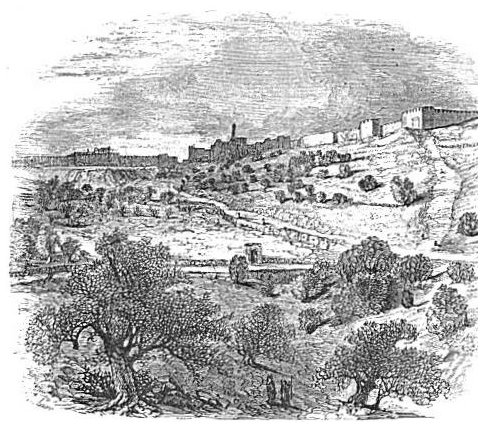 |
| THE VALLEY OF GIHON. |
west of Joppa gate, the valley is known as the Valley of Gihon. The chief portion of the upper part is cultivated in much the same manner as the lower part. In the above cut we look up the Valley of Gihon to the western wall of the city.
§ VI.
JERUSALEM: ITS STREETS, PUBLIC BUILDINGS, ETC.
There are only four streets in the city of Jerusalem which are dignified by names, and all these seem to have been named by Europeans.
The first of these with which the traveler becomes acquainted is David Street. It commences at the Joppa gate and runs almost due [165] east through the city to the principal gate into the har'am. It is nearly a straight line; but just before crossing the Tyropeon Valley it makes a right angle to the right, and, after running south a few steps, another right angle to the left, resuming its original course. From the last angle to the har'am it has the name of Temple Street. David Street is about twelve feet wide between the houses, with sidewalks about two feet wide and slightly elevated.
The Joppa gate, which admits us into this street, is a strong tower thirty-six feet square, with its sides toward the cardinal points of the compass. The gateway is not on its western side, as one would naturally expect, but on that portion of its northern side which projects in front of the wall. You approach it by a road parallel with the wall which runs off to the northwest. Entering here, by a door twelve feet wide and sixteen feet high, you turn square to the left, and enter the city through a similar opening on its eastern side. This arrangement was intended for the better defense of the gateway against an enemy trying to force his way through. The shutter is a folding door made of timber five or six inches thick, covered with sheet-iron, and thickly set with the heads of iron bolts. This gate, like all the others of the city, now stands open night and day; so that visitors are no longer under the necessity, as they were a few years ago, of getting inside of the city before sunset to prevent being excluded for the night. A military guard is kept at each gate, but chiefly to regulate the ingress and egress of the soldiers of the Turkish garrison. Perhaps their presence also tends to preserve the quiet and good order which always prevail among the comers and goers. Through this gate pass more than half the people who go in and out of Jerusalem; and the level space in front of it is always crowded with motley groups of men, women, and children; beggars, camels, and donkeys. All styles of dress are seen, and many different languages are spoken.
After passing through this gate you see before you an open space of irregular shape, bordered on the right by a low wall guarding the moat of the citadel, and on the left by a garden-wall and some small houses. The space varies from six to ten yards in width, and stretches about seventy yards before you on a level, when it begins to descend, and soon enters the narrow mouth of David Street. Along this descent on the left are two stores, kept on the European plan and supplied with European articles; and next to them is the Mediterranean Hotel, a two-story building of stone, with comfortable rooms and good accommodations. It is kept, and has been for many years, by a German named Hornstein. He was one of Dr. Barclay's converts while a missionary in [166] Jerusalem. Passing the hotel and entering David Street, you continue to descend until you reach the angle in the street above mentioned. In this descent you cannot keep the sidewalk, on account of meeting persons whom you cannot pass without stepping into the street, and on account of persons, baskets, boxes, etc., occupying it in front of the open shops. The stones of the street are so slick, of so many different sizes, and so rounded on the top, that it requires constant care to maintain a perpendicular, and walking on them is laborious. The street is nearly always crowded, and while no vehicles of any kind are ever seen in the city, you meet many loaded camels and asses, which occupy nearly the entire street, and they turn neither to the right hand nor to the left to avoid a collision with you. The bazaars here are devoted chiefly to the sale of groceries and other provisions, including vegetables and fruits, and the traffic is chiefly in the hands of Turks and Ar'abs. About the angles of the street towards the har'am are the shops which deal in dry goods, and here, besides the Ar'ab dealers, are many Jews. Here the street is covered overhead, partly by arches and partly by matting stretched on poles. It reaches the har'am on a level with its surface, showing that here the Tyropeon Valley has been filled up to a level with the top of Mount Moriah. On the right, as you pass down David Street, are a number of narrow alleys leading up the slope of Mount Zion, some of them so steep that they are ascended by steps. On the left you occasionally pass a mill, and occasionally a house devoted to the buying and selling of grain. Indeed, the amount of traffic on this street, and the stir and business activity, are quite a surprise to any one who enters Jerusalem with the idea that it is a dead city. On your left, as you enter this street from the Joppa gate, the ground rises by a gradual slope northward. But below the Mediterranean Hotel the ground to the left runs off for some distance on a level, and farther down the street there is a descent to the left which increases as you advance. This arises from the fact that David Street occupies a bench cut along the northern side of Mount Zion. It slopes downward only fast enough to strike the level of Mount Moriah at its farther end.
If you enter the city from the east you pass through St. Stephen's gate. The principal street from this gate runs westward entirely across the city nearly parallel with David Street, the space between the two being about two hundred yards wide. This is the Via Dolorosa.51 [167]
St. Stephen's gate is a square tower like the Joppa gate, but does not, like it, project beyond the wall. Its door is immediately in front; but after you enter the tower you turn square to the left and enter the city through its southern side. As you do so you see before you a narrow street, 200 feet long, leading along the city wall to the north end of the har'am, and entering that inclosure through a narrow gateway in its wall. On the right of this street, all the way, is the so-called Pool of Bethesda, of which we will give a description in another section.52 Turning westward at the gate you see the Via Dolorosa stretching before you, with a gradual rise as it advances. On your left for a considerable distance, filling all the space between the street and the har'am wall, is the Pool of Bethesda. A wall six feet high guards against falling into it. On your right, opposite the pool, is the church and convent of St. Anne, belonging to the Latin Church, and dedicated to Anne, the supposed mother of the Virgin Mary. After passing the pool the remainder of the space between the street and the northern end of the har'am is occupied by the barracks for the Turkish garrison. This pile of buildings is supposed (for reasons which have satisfied nearly all the explorers of Jerusalem) to occupy the identical sites of the house of Pontius Pilate, and the castle of Antonia in which Paul was confined by the chief captain.53 Two narrow passages run through under this mass of buildings from the Via Dolorosa into the har'am, making, with the one above mentioned, three entrances into the northern end of that inclosure.
Opposite the northwest corner of the barracks stands a Latin convent, and from its wall springs an arch which spans the narrow street and supports a small room with a window looking eastward. (See the cut on the opposite page.) This is called Pilate's arch, or the arch of Ecce Homo, because of a tradition, dating from the fifteenth century, that here Pilate caused Jesus to be led forth, and exclaimed, "Ecce Homo!"--"Behold the Man!"54 At this point the Via Dolorosa, having maintained a slight ascent from the lower corner of the barracks, begins a rapid descent toward the west. This descent leads into the bottom of the valley which separates the hill Beze'tha, the southern end of which we have just crossed, from Ak'ra. The Via Dolorosa here turns to the left and follows this valley southward for a short distance, when it makes another angle to the west, and continues with a constant ascent up the slope of Ak'ra to the western side of the city. About one hundred yards from the last-mentioned angle it passes the [168] Church of the Holy Sepulchre, where tradition locates the crucifixion and burial of Jesus; and along the course of the street from the arch at the convent to this church are pointed out by the superstitious
 |
| VIA DOLOROSA,--PILATE'S ARCH. |
priests of the city the spots at which all the incidents of the march of Jesus from Pilate's house to Golgotha that are mentioned in the Scriptures, and several which the Scriptures do not mention, took place.55
The principal cross-street running north and south and connecting [169] the two streets which we have now described is Christian Street. On leaving the Mediterranean Hotel and descending David Street, at a distance of seventy or eighty yards you come to the southern end of Christian Street, and turning into it by a right angle you follow it to the Via Dolorosa. It runs almost on a level, and it is the seat of the Christian Bazaar, or the shops kept by Christians of the Greek and Latin Churches, together with a few kept by Protestants and Jews. Many of these shops are kept very much after the European style, and among them are a bookstore, an antiquarian establishment, and a regular European dry-goods store.
If you return to David Street and pass farther eastward, before reaching the corner of Mount Zion you cross Damascus Street, along which, as far as the eye can reach to the left, you see the Turkish Bazaar. This street, starting southward from Damascus gate and crossing the Via Dolorosa at a right angle, here crosses David Street at a similar angle, and continues its course southward until it reaches Zion gate, in the southern wall of the city. It is the longest street in the city, and that part south of David Street is called Zion Street. A group of short covered streets near the intersection of David and Damascus Streets accommodate the principal bazaars for the sale of dry goods, boots and shoes, saddlery, and all the articles of like character manufactured or sold by Turks, Ar'abs, and Jews.
The city is divided into four distinct quarters, named according to the predominant population in each. All that portion which lies south of David Street is divided into the Armenian quarter toward the west, and the Jewish quarter toward the east. Zion Street is the dividing line. The portion north of David Street is divided into the Christian quarter, which includes all the northwestern part of the city, and the Turkish, which includes all the northeastern part. Damascus Street is usually put down as the dividing-line between these two quarters. None of these quarters must be understood as being strictly exclusive, for while there are certainly very few besides Jews in the Jewish quarter, and few besides Christians in the Christian quarter, both Jews and Christians are found in all the quarters, and the Protestant Christians are located chiefly in the Armenian quarter.
The first public building that strikes the eye of a visitor is the citadel, or "Tower of David," which stands immediately south of the Joppa gate, and is partly hid from view by the tower of that gate as you approach it on the Joppa Road. This is an irregular group of five square towers, all constituting one fortification, and surrounded by a moat. The moat is about thirty feet wide at the top, and where it [170]
 | ||
| AMERICAN CONSULATE. | A VIEW IN JERUSALEM. | TOWER OF DAVID. |
| Page 171. | ||
has not been filled up to some extent it is about twenty feet deep. It is walled on the outer side, and, this wall rises about three feet above the surface to prevent persons and beasts from falling into the moat. The moat is 460 feet long on the western side, which is outside the city, and it is nearly as long on the eastern side. On the other two sides it is about half as long. From the bottom of the moat on its inner side the foundation-wall of the towers rises at an angle of about 60°, until it reaches the level of the exterior surface, but the upper wall resting on this is perpendicular. This foundation-wall is built of very large stones, many of them eight or ten feet long and three feet thick, and they bear the ancient "Jewish bevel," which indicates that they are of early Jewish origin. The upper part of the structure is evidently modern, and probably dates from the last reconstruction of the walls, in 1542. Its entire height is about eighty feet. A few small pieces of cannon are mounted on the towers, and the citadel is occupied by a garrison of Turkish soldiers.
Immediately left of the citadel, across an open space resembling a wide street, is the American Consulate; and standing back from this street is the English church, with the residence of the English Bishop of Jerusalem adjoining it. Both the latter are handsome buildings of stone. Services in English are held in the church every Lord's day; and nearly all the Protestant residents of the city, as well as travelers who speak English, attend these services.
The open space just mentioned between the citadel and the English church runs on southward, narrowing into a street, and passes the barracks on the right and the extensive inclosure of the Armenian church and convent on the left. A large gateway on the left admits you into a court, whence you have access to the Armenian Church of St. James, a large and massive building with tawdry decorations. The residence of the Patriarch is farther south; and also an extensive and irregular group of buildings occupied by the priests and monks of the Armenian faith. The cut on the opposite page gives a correct view of this part of the city. In the portico of the Church of St. James the visitor is struck with two interesting objects: one an immense plank of hard wood suspended on chains, which is struck with wooden mallets to call the priests and monks to prayer (answering to the bell in Latin convents), and a cistern supplied with a little metallic bucket, from which you are at liberty to draw and drink the coolest and purest water to be found in Jerusalem.
In the Jewish quarter there are four or five synagogues, but only two of them are at all conspicuous. Both of these are square structures of [171] considerable height, with large plastered domes of masonry rising above them. The newer and larger of the two is situated on the highest part of Mount Zion towards its northeastern curve, and is one of the most conspicuous buildings in the city. Its large dome, painted a lively green, attracts especial attention. It was completed only a few years ago.
Returning now to the Joppa gate, and going northward along a narrow street between that gate and the Mediterranean Hotel, you find the northwestern part of the city occupied by extensive buildings belonging to the Latin Church, the most conspicuous of which are the Bishop's residence, with a beautiful little flower-garden along its western side, and a large new college, erected in 1878 by the Franciscan monks. The residence of the Greek Patriarch is also in this part of the city, and a large Greek monastery lies between it and Christian Street, with an entrance on the latter street. Very great improvement has been made in this part of the city recently.
The most famous building in the city, and by far the most interesting to those who believe the current traditions in regard to it, is the Church of the Holy Sepulchre. It is situated not far from the angle between Christian Street and the Via Dolorosa, but it is separated from both of these streets by smaller houses which are built against its walls and extend out to the street, completely hiding the church. Its walls are nearly everywhere hidden by adjoining houses; but a small open square on the south side gives access to its principal entrance, and a section of the front of the building, about fifty feet, is visible. This view of it is given in the cut on the opposite page. The church is surmounted by two domes, one a very large one, which towers above all surrounding buildings and is a conspicuous object in the view of the city from a distance. The dome seen in our cut is the smaller one.
It would require many pages in this book to give a description of this church, and it would be impossible to convey to persons not familiar with similar structures an adequate conception of it. We will, therefore, mention only its principal features and then pass on. It is a very irregular mass of buildings, extending about 230 feet east and west, and about 200 north and south. In the centre of the rotunda under the great dome (which is to the left of the one seen in our cut) is a little building of white marble, 26 feet long by 17 wide and about 15 high, wherein is the Holy Sepulchre proper. Its outer wall is elaborately carved, and burning lamps of silver and gold hang thick about it, while enormous candles in tall candlesticks of marble and silver stand in front of it. It is divided into two rooms, and the entrance is [172]
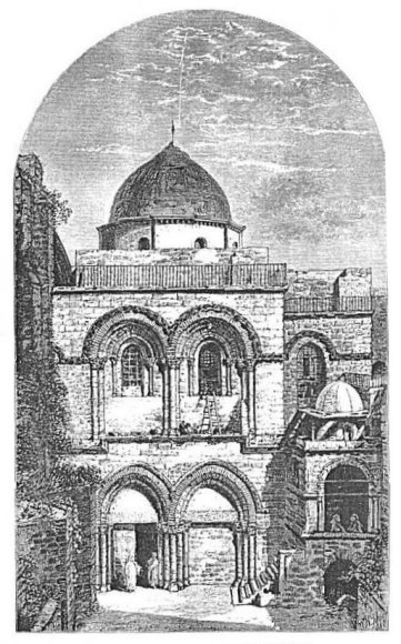 |
| FRONT OF CHURCH OF THE HOLY SEPULCHRE. |
| Page 172. |
through a door in the eastern end, visible in the cut. The first room is called the Chapel of the Angels, because it covers the spot where the
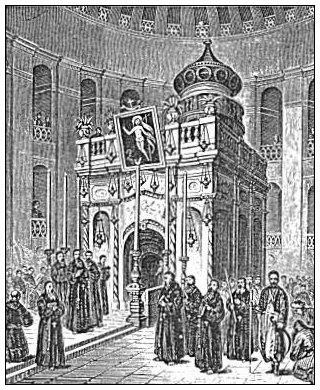 |
| THE HOLY SEPULCHRE. |
In different parts of the great edifice are large chapels, belonging separately to the Greeks, the Latins, the Armenians, and the Copts. Of these the Greek chapel is by far the most elaborately ornamented. It glitters with ornaments of gold, silver, and precious stones. Besides these there is a multitude of small rooms and recesses, each the chapel of some particular saint.
The tradition-mongers have collected within this building all the spots made sacred by incidents connected with the crucifixion. They show you the spot where Jesus was nailed to the cross; a hole in the marble floor of the church, faced with silver, in which the lower end of the cross was placed; and just five feet distant on each side the sites of the crosses of the two thieves. A cleft in the rock, about 4½ feet from the foot of the cross and about six inches deep, is one of the [173] clefts made by the earthquake when Jesus died, and it is said by some to reach to the centre of the earth! Between the cross and the sepulchre is shown the very spot where the body of Jesus lay as Joseph and Nicodemus were anointing it, and a little to one side is the chapel of Adam, marking the spot where this venerable patriarch was buried. It is said that the blood of Jesus flowed through the cleft in the rock above mentioned until it touched Adam's skull, when he was restored to life. In another place a hole in the wall is shown where his skull is yet preserved. You can put your hand into the hole, and you are expected to believe. They show you a prison in which Christ was kept while his cross was being prepared, and another little room in which the soldiers parted his raiment. They show you the tombs of Nicodemus and Joseph of Arimathea;56 a piece of the column to which Jesus was tied while they scourged him, and another piece of a column which stands in the exact centre of the world. Other things equally impossible or incredible, and almost without number, make up the wonders of this building,--the centre of an astonishing superstition, and the annual resort of tens of thousands of pilgrims.
In this church is annually enacted, during the festival of Easter, one of the most disgraceful and shameless frauds ever invented in the name of religion. Through a hole in the wall of the Chapel of Angels above described the Greek Patriarch, concealed within, passes out a torch lighted with fire which has just descended from heaven. A crowd of pilgrims filling every part of the church, and packed together in a solid mass until not another human being can find admittance, are waiting in darkness, with bunches of wax tapers in their hands which they are to light from the heaven-descended fire. The latter is passed rapidly about over the heads of the seething mass until all the tapers are lighted. In the mean time the superstitious devotees bathe their hands in the flame, and scorch their clothing with it, under the belief that it will bring many blessings to them. The tapers, after burning a little while, are carried to the distant homes of the pilgrims, and are there objects of devout reverence, as are the pilgrims themselves. Not only the Greeks, but the Armenians, the Copts, and all other Eastern sects, take part in this farce, and its origin dates back beyond the ninth century. Until the sixteenth century the Latins participated in it; but since then they have been indifferent to it. Lieutenant Conder, who twice witnessed the scene, and gives a very full [174] description of it, closes his account with these words: "Every educated Greek knows it to be a shameful imposition; but the ignorant Syrians and the fanatical Russian peasants still believe the fire to descend from heaven. The clergy dare not enlighten them; and that crafty diplomacy which encourages pilgrimages to Jerusalem by government aid fosters the superstition, which is the main inducement for the Russian pilgrims to visit the Holy City."57
The number of pilgrims who visit the city on these occasions is sometimes estimated as high as 20,000. A very large number of them are from Russia. Most of them are very poor people, who spend all of their earnings in the pilgrimage. Many are very old, and all are stolidly ignorant and superstitious.
The question whether the Church of the Holy Sepulchre occupies the true site of Golgotha and of the sepulchre of Jesus, has elicited a vast amount of discussion. Dr. Robinson was the first intelligent explorer of modern times to vigorously argue the negative. The decision depends chiefly on the question whether this site, which is now in the midst of the city, was within or without the walls in the time of Christ. The Scriptures make it entirely certain that the crucifixion occurred outside the city (John xix. 20; Heb. xiii. 12), and the excavations made by Lieutenant Conder show that the "second wall," as the northwestern wall of the city at that period is called, must have been outside the site of this church. If it had not been, it would have stood on a hill-side with the highest part of the hill rising above it on the outside,--a position never chosen for the wall of a city where it can possibly be avoided.58 At present the church is about two hundred yards within the wall at the nearest point. For an elaborate argument on the subject, see Robinson, i. 407-418.
The actual site of Golgotha and the sepulchre cannot be determined with certainty; and no wonder, when we consider the number of sieges which the city has undergone, during which the entire surface outside was greatly changed, and the walls repeatedly thrown down. Dr. Barclay conjectures that it was on the shoulder of the hill just north of St. Stephen's gate, a very suitable locality, and nearer than any other to the supposed site of Pilate's house whence Jesus was led forth. Conder locates it on a knoll a short distance without the Damascus gate,--a much more probable location than that covered by the Church of the Holy Sepulchre. Many other conjectures have been advanced; but it seems to the author that the choice of an [175] unprejudiced visitor to the city must lie between the two just mentioned, with a slight preponderance in favor of the former.
§ VII.
THE HAR'AM.
In the second section of this chapter we have given an account of the work done on Mount Moriah by Solomon, and in the fourth section a brief account of important changes made since the close of New Testament history. In those sections we anticipated to some extent the description of its present condition.
The entire inclosure of about 35 acres, having an average length from north to south of 1572 feet, and an average width of 985 feet, is now called by the Arabs the Har'am es Sherîff', the Noble Sanctuary, and it is regarded by the Moslem as the most sacred place in the world next to the temple at Mecca. The name by which it is most usually designated is simply "The Har'am." It is wider at the northern end than at the southern, and longer at the western than at the eastern side. The two principal buildings within this inclosure are the Dome of the Rock, already mentioned (p. 158), and the Mosque el Aksa. The latter occupies the southwestern corner of the area, facing north, and the former stands a little nearer the northern than the southern end, and a little nearer the western than the eastern side. The dome stands on the highest natural level in the entire har'am, and it is surrounded by a paved platform which is elevated above the surrounding area. This platform, like the har'am area itself, is nearly, but not quite a rectangle. Its eastern side is 528 feet long, while the western is 544 feet. Its southern side is 425 feet, and its northern 506. The northwestern and southwestern angles are nearly right angles, while the northeastern is an acute angle, and the southeastern slightly obtuse. It has an average length north and south of 536 feet, and an average width of 465 feet. Its outer edge is about 10 feet in most places above the surrounding area, and is supported by a perpendicular wall. The ascent is made by two broad flights of steps on each side. On the top step of each of these flights stand five marble columns supporting an arcade of four Saracenic arches, under which you step upon the platform. The pavement of the platform is not marble, as many have represented it, but a smooth white limestone. The remainder of the har'am area is unpaved, and its surface is irregular.
The most frequented entrance to the har'am is that from David [176]
 |
| NORTH WALL OF HARAM,--TURKISH BARRACKS. |
| Page 176. |
Street, through the Cotton Bazaar. Here is the largest and finest of the gates now in use. On entering through it you see the platform immediately before you, and on it the dome a little to your left. One flight of steps leading up to the platform is near you to the left. As you turn round to examine the wall through which you have just passed, you see that it is used as the rear wall of houses almost continuously built against it, with their upper stories resting on top of it, and their upper windows looking into the har'am. You also see as you glance along this wall four other gates, which, like the one by which you have entered, are approached from the city by streets which pass under archways through the thickly-crowded houses.
Moving northward between the west wall and the platform, which are here about fifty yards apart, until you pass the latter, you have before you, in full view, the entire northern wall of the area. The western end of it is really the wall of the soldiers' barracks; but immediately at the corner, and for a hundred or more yards eastward, the natural rock shows a perpendicular face from thirty down to ten feet above the surface, and supports the wall of the barracks, which rises fifteen or twenty feet higher. The barracks extend about one-third of the way across the northern end of the area, and the remainder of the distance is occupied by a wall about twenty feet high. The ground has a slight downward slope towards the east all along this wall. As we have said before, there are three small gateways through this wall, making, with the five on the western side, eight gates through which ingress is obtained at the present time. All the surface in the northwestern corner from the wall to the platform, a distance of about one hundred yards, is the natural rock, which has been cut down from a sharp ridge to its present level, leaving the perpendicular rock just mentioned to mark its original elevation.
Standing on the natural rock-surface just mentioned, and looking southward, you obtain the best view of the Dome building, and you see immediately before its eastern front a small structure of similar shape, which appears at first glance like a miniature copy of the great building, or a small model after which the latter was constructed. It is called the Dome of the Chain, and sometimes the Praying-Place of David. You also see scattered about the platform a large number of diminutive cupolas, each resting on four columns, which are praying-places for the Mohammedan worshipers. They are more numerous on this side than on any other, for the reason that here the worshipers can face Mecca, which is indispensable in their prayers, and at the same time face the sacred dome. [177]
We now pass farther to the east, with a view of examining that part of the har'am which lies east and south of the platform. When you reach the point at which the northeastern corner of the platform is on your right, the Golden Gate, which once admitted persons into the area from the east, is before you. The outer entrance to this gate is walled up, and the time is not certainly known when it was otherwise; but the entrance to its tower from the inside is still open. Its floor, however, is at least twenty feet below the level of the area on which you stand, and in order to enter it you must descend a steep path between two sloping banks of earth. This gate, when in use, was more magnificently adorned with columns and carved slabs than any of the present gates of the city, and it was also more commodious. Its tower, measured on the inside, is 68 feet east and west, and 34 feet north and south. It is divided longitudinally by a row of columns into two passages, at each end of which were the corresponding openings of the double gateway. It was intended for ingress by one passage and egress by the other, and contemplated a great concourse of people. On the outside it must have been reached by paths running beside the wall on the top of the steep side of the Kedron Valley, or by steps ascending from a bridge across that valley. Dr. Barclay supposes that a magnificent bridge, constructed of arches upon arches, spanned the valley on a level with this gate.59 After entering and passing through this gate, the level of the temple area within must have been reached by another flight of steps twenty feet high. These have entirely disappeared.
All about the uneven ground near this gate there is a growth of rank weeds and cactus, imparting to the place a neglected appearance; and as we go farther south the same air of neglect prevails. The southern half of the area is dotted with a few ill-shaped olive-trees; and a half-dozen cypresses, of a feeble growth, stand in the space immediately south of the platform. The wall along the eastern side of the har'am, from the vicinity of the Golden Gate to its southern end, is about ten feet high on the inside. If you ascend the wall here by a flight of steps which is at hand, and look over, you see evidence of the leveling which we have described in the second section of this chapter. While the ground is only ten feet below you on the inside, it is between sixty and seventy along the outside, except near the southeastern angle of the wall, where it is eighty feet. Close to the steps by which you have ascended there is a granite column built horizontally into the wall, and projecting about four feet beyond it on the outside. On this, [178] according to Mohammedan belief, the prophet will sit in the day of judgment, while all the world will be assembled in the valley below. A fine wire will be stretched from this column across the valley to the Mount of Olives, and only such souls as can walk across on it will enter Paradise. The "faithful" will be steadied by the hands of angels, but all Jews and Christians will fall into the abyss below.60
Near the southeast corner of the inclosure is a stairway by which we descend into the so-called Solomon's Stables, the substructions which support the surface of this part of the area. The original construction and design of these we have stated in section second of this chapter, and we have given a cut of them on page 149. The open space occupied by the piers which here support the surface of the har'am, is irregular in shape. Its greatest extent east and west is 319 feet, and from south to north 247 feet. The pillars are about 3½ feet square and 30 feet high, and the stones of which they are built are about 5 feet high. The style in which they are built is exhibited in the cut on page 149. The thickness of the vaults and earth resting upon these is about 5 feet, so that a person walking about on the southeastern part of the har'am area stands upon a thin crust of earth and stone 5 feet thick, supported by an open colonnade 30 feet deep.61 Captain Warren thinks that this entire work is a comparatively modern reconstruction out of the ancient and original material; and Dr. Barclay concurs with him in regard to the vaults, but not in regard to the pillars which support them.
Returning from these vaults to the surface, we pass westward along the southern wall to the Mosque el Aksa, which occupies the southwestern corner of the har'am. The name means "the mosque far away," that is, far away from Mecca. It was originally a church, built by the Emperor Justinian in the sixth century, in honor of the Virgin, and called the Church of St. Mary. The central portion of the present building, about 280 feet deep from north to south, and 190 feet wide, retains the original form. It was changed into a mosque by the Mohammedans in the seventh century, restored by the Crusaders to a church in the eleventh century, and again turned to a mosque in the twelfth century. A long, narrow wing, supposed to have been built by the Crusaders, extends westward from the right-hand side, near the rear of the building. It is about 220 feet long and 60 feet wide, with a low ceiling supported by columns. It is supposed that the Crusaders used this for an armory. A much smaller [179] wing opposite this extends eastward about 90 feet, with a width of 21 feet. At the northeast corner is another wing extending about 100 feet eastward, which is used as a military magazine. Across the front of the central part of the structure extends a porch 180 feet wide and 20 deep, which is entered under an arcade of seven handsome pointed arches, supported on massive piers.62 Opposite these are seven
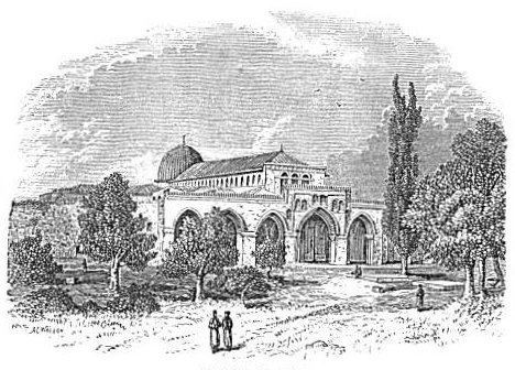 |
| MOSQUE EL AKSA. |
corresponding doors opening into the interior. A flight of steps on the right hand, in front of the mosque, leads to extensive vaults beneath its floor, and at the most southern extremity of these is an ancient closed-up gateway, called the Double Gate. When that gate was in use it led through this vaulted passage, and up the steps just mentioned, into the temple area. Two other gates through the southern wall, the triple gate, a short distance east of the mosque, and the single gate, still farther east, also led into underground passages, and through them, by flights of steps, up to the surface of the temple area. Their low position was made necessary by the low level of the surface of Ophel outside the wall, which varies from 30 to 60 feet below the inside surface of the har'am.
Leaving the mosque, with your face northward, you turn a little to [180] the right in advancing directly to the steps of the platform, and on your way you pass a large fountain which would add much to the appearance of the grounds if it were full of water and its jet playing; but it is dry and out of use. Ascending the principal flight of steps, you stand on the sacred platform frequently mentioned before, and looking about to see the condition of its pavement, you observe that although the stones are all sound and in place, grass and weeds are allowed to grow here and there between them. In former years, Christians were required to bare their feet before walking on this pavement, but now this is required only on entering the Mosque el Aksa and the Dome of the Rock; and even in these you are allowed to walk in slippers, leaving your boots outside.
On your left, as you stand at the head of the steps just ascended, is a marble pulpit about 12 feet high, ascended by marble steps and surmounted by a small dome supported by four columns. During the fast of the month Ramadân'63 a preacher delivers a discourse from this pulpit to an audience seated on the pavement about it, every Friday. You now fix your attention on the noble building before you, called Kubbet es Sakhra, the Dome of the Rock. It has long been called by Christians the Mosque of Omar, through the double mistake of supposing that it is a mosque and that it was built by the Calif Omar. That which attracts your chief attention, and with which the eye is never wearied, is the magnificent dome which springs from the flat roof of the building. This dome is 65 feet in diameter at its base, and 97 feet high from base to apex.64 The apex is 170 feet high from the ground.65 It is covered with lead, almost black from exposure, and is surmounted with a large gilt crescent. The peculiar grace of the curve with which it springs from the drum on which it rests, and that with which it reaches its crescent-crowned apex, distinguish it for beauty of outline above all other domes, perhaps, in the world. From whatever point it is viewed, whether from the har'am area, the city wall, the Mount of Olives, or any other height about the city, it is the most prominent and pleasing object in Jerusalem.
The building on which it rests is an octagon, each of whose sides is 67 feet long and 46 high. On the four sides which look toward the four cardinal points of the compass are doors covered by porticos. Windows of richly-stained glass and pointed arches stand close [181] together all round the building. The walls are covered with panels of variegated marble as high as the window-sills, about one-third the height of the building, and thence to the top with porcelain tiles of blue, black, green, yellow, and white. If the height of this part of the building were greater, the appearance of the entire structure would be more pleasing.
From the central part of the flat roof of this octagonal structure rises the drum of the dome, 27 feet in height. It is pierced by sixteen windows filled with stained glass of dark colors, and its outer surface is ornamented by colored porcelain in beautiful patterns. The cut on the opposite page is as good a picture of the entire structure as can be made without colors.
Entering the building by its eastern door, and proceeding at once to its central part, we discover, immediately under the great dome, the object which gives name and character to the entire building. It is a mass of the natural limestone rock of the mountains top, of irregular surface and outline, about 6½ feet high near its western side, and sloping down nearly to the level of the floor along its eastern side. On the western and northern sides it shows marks of cutting, where blocks have been quarried from it, but elsewhere it is in its natural state. Its width is 28 feet across the northern end, and 38½ feet near the southern end. Its greatest length, measured along its eastern side, is 52 feet.66 It is surrounded by a wooden partition 5 feet high, over which visitors are not allowed to pass, and which prevents such access to it as is necessary for exact measurement. A rich canopy of crimson silk, mentioned by all of the earlier visitors, and by Lieutenant Conder as late as 1875,67 was formerly suspended over the rock, but it had been removed when the author was there, in 1879, and there was nothing above the rock except the inner surface of the lofty dome, richly ornamented with panels of blue, red, and gold, and a candelabra suspended over the centre of the rock by a brass rod whose upper end reached the apex of the dome. The stained-glass windows in the drum of the dome shed a dim and sombre light over all. At the southeast corner of the rock is a pulpit 5 or 6 feet high, from which is obtained a good view of the entire surface of the rock. Adjoining this pulpit is a reading-desk, on which are kept some ancient and very large manuscript copies of the Koran, the pages of which are 30 inches square. Immediately [182]
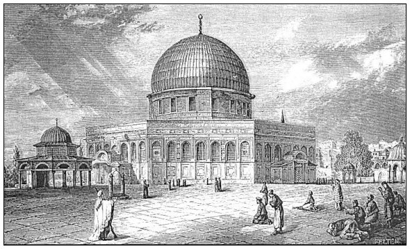 |
| DOME OF THE ROCK. |
| Page 182. |
to the east of this pulpit a flight of steps 6 or 8 feet wide descends into an artificial cavern cut under a portion of the sacred rock. It is a room about 24 feet square, with a ceiling of uneven height, but averaging 7 feet. Its walls are plastered and whitewashed, but its ceiling is the natural rock, and its floor is paved with marble. Near the centre is a circular marble slab 3 feet 5 inches in diameter, which covers the mouth of a well, as is obvious from the hollow sound which it emits when struck. In the ceiling, at a point nearly above this slab, there is a circular hole 2 feet 9 inches in diameter, extending entirely through the rock. The eastern rim of this orifice is directly above the western rim of the one below. In the corners of this room are pointed out by the superstitious guide the praying-places once used by David, Solomon, Abraham, and Elijah. There is a spot in the ceiling where Mohammed bumped his head and made a depression in the rock.
The Moslem tell many marvelous stories concerning this rock. When Mohammed made his celebrated flight to heaven and back he started from its surface, and it began to follow him, but the angel Gabriel laid his hands on it and stopped it after it had risen to its present height above the surface. Two rough depressions near the southwest corner of the rock were made by the angels hands. Since then the rock has hung suspended in the air without support, the hollow place under the cave within it being proof that it rests on nothing. The slab concealing this hollow place is the mouth of the well of departed spirits; and here the spirits of pious Moslem assemble twice a week to pray. It is claimed that the rock itself came from Paradise. Mohammed said that one prayer offered here was worth a thousand offered elsewhere; and he himself prayed a short distance southwest of the rock, and left his footprints here on the face of the stone. They are seen to this day. According to some, when he started to heaven he was in the cave, and the upward darting of his body punched the hole above mentioned in the ceiling.
The rock is revered by Jews no less than by Moslem. It is with them the most hallowed spot on earth. It is the rock which Jacob used for a pillow when he saw the vision of the ladder, and which he called Bethel, the House of God. On it Abraham had previously built his altar to sacrifice Isaac. It was included in the threshing-floor of Araunah; it is the spot on which David offered sacrifice to stay the plague;68 and it was covered by the Most Holy place of Solomon's temple. Here Jeremiah concealed the ark of the covenant when [183] Jerusalem fell into the hands of the Babylonians, and it lies buried beneath this rock to the present day.
When we brush away the dust of these superstitious traditions, and look at the matter with a dispassionate eye, the indisputable fact remains that here stands a portion of the rock summit of this mountain, which, for some reason, was left a rugged and shapeless protuberance when all around it was leveled. Since the seventh century of the Christian era, when Jerusalem fell into the hands of its Ar'ab conquerors, it has been revered and carefully guarded as a sacred rock, and all the modern traditions concerning it are but the results of vain attempts to account for its original sanctity. Furthermore, it is itself the very summit of Mount Moriah, the spot which Abraham would naturally choose for the offering of Isaac; and around it, if it stood there in Araunah's day, this tiller of the soil would naturally have made the circuit of his threshing-floor. And when Solomon built his temple on the same mount, it is hard to believe that he did not choose the summit for the site of the sacred edifice; and if so, it is impossible that this rock, if not covered by it, could have been far from it. If it ever served a practical purpose, it did so previous to the Mohammedan possession; for since it fell into the hands of its present custodians, it has been preserved as a mere relic. Mr. Ferguson, in his work on Jerusalem, and in Smith's Dictionary, advanced the opinion that the cavern under it was the sepulchre of Christ; but no one now accepts his theory. Others have suggested that it was originally a cistern, and the hole in its top the cistern's mouth.69 Others again have conjectured that Solomon's great brazen altar, which was thirty feet square and fifteen feet high, covered a part of it, the orifice through the top into the cave being left at one side of the altar for the blood of the victims to flow through, first into the cave and thence by the opening, now closed up, into an underground passage through which it was washed away into the Kedron Valley. None of these hypotheses have met with more than partial reception, and the reader will see, by a little reflection, that they are all liable to serious objections. Perhaps the mystery will be solved when the superstition of the Mohammedans in regard to it, already greatly relaxed, shall be so completely dispelled as to allow an examination of the well beneath the rock, and of the natural surface now covered by the floor round about it.
Immediately around the sacred rock are the supports of the dome and its drum. These consist of a circle of four piers and twelve columns, [184] three columns in each of the four spaces between the piers. The piers and columns are of marble, and the latter are surmounted with Corinthian capitals, richly gilded. Above these, graceful arches, composed of alternate blocks of black and white marble, springing from the tops of the piers and columns support the drum of the dome. An iron railing twelve feet high extends from pier to column all round the circle, and a gate through this railing on the eastern side admits the visitor to the irregular space about the rock. At the south and southeast parts there is no such space, the rock itself reaching out to the railing.
Between this circle of piers and columns and the outer wall of the building there is a space all round of about forty-three feet. Within this space, thirteen feet from the wall and thirty feet from the inner circle of columns, is an octagon, composed of eight piers and sixteen columns, a pier alternating with every two columns. These, with the arches above them, furnish a middle support to the flat roof of the structure which surrounds the inner circle of columns; and according to Conder's conjecture they constituted the external limit of the original building, while the additional thirteen feet and the present outer walls are a later addition.70 If this conjecture is true, and it seems to be sustained by the reasonings in its favor, the building once possessed more pleasing proportions than at present; for no one can fail to observe that the present walls appear too low for their extent.
Immediately in front of the eastern door of the Dome building is the beautiful structure already mentioned, called "the Dome of the Chain."71 It is seen in the cut opposite page 182. It is said to be the model from which the Dome of the Rock was constructed; and if the outer parts of the latter building were removed, the two would be almost identical in form. The dome of this structure is supported by a circle of columns, and the flat roof surrounding the drum of the dome by eleven columns, making the outer circuit of the structure an endecagon. It is the only building and the only figure of any kind ever seen by the author, outside of a book on geometry, with eleven sides. Its entire diameter is 42 feet. Its pillars are 11 feet high, all of marble, and 13 feet apart from centre to centre. Its floor is laid with marble blocks of various colors, and the interior of the dome is tastefully ornamented with porcelain in small figures of blue and white. The space between the [185] two most southern columns, a little east of south from the centre, and therefore in the direction of Mecca, is closed by a niche as if for a statue, but really it is a Mohammedan place of prayer.
The surface of the platform and of the entire area is almost honeycombed with cisterns and reservoirs for the storing of water. Captain Warren found, and partially examined, thirty-three of these, and the most unobservant visitor cannot fail to notice the curb-stones of many of them, and to see men drawing water to drink from one or more on the western side of the platform. One of those explored by Captain Warren is 42 feet deep, 63 feet long, and 57 feet wide. Its walls are chiefly of masonry covered with cement, and it had about three feet of water in it when explored. The author dropped his tape-line into it, and found the same depth of water.
Another reservoir, still larger than this, and first explored by Dr. Barclay, lies north of the eastern extension of the mosque El Ak'sa.
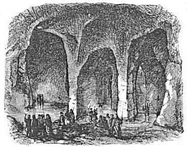 |
| THE ROYAL CISTERN OF THE TEMPLE. |
You obtain access to it by a well-like opening near the wall of the mosque, which leads to a flight of stone steps cut in the natural rock and descending into the southern side of the reservoir. It is an artificial cavern of very irregular shape, 42 feet deep and 736 feet in circuit. Rude pillars of the natural rock are left here and there to support the ceiling. When Barclay explored it the water was about knee-deep. When seen by the author it was about four feet deep over the principal part of the bottom. The rain-water from the roof of the [186] mosque runs into it, and no other source of supply has been discovered. It is sometimes called the Royal Cistern.
So jealous are the custodians of the har'am in regard to explorations in its sacred inclosure, and so utterly opposed to excavations there, that but little is known in regard to the connection of the cisterns and reservoirs with one another, and their sources of supply. There are many orifices in the pavement of the platform, evidently intended to convey the rain-water which falls upon it into cisterns beneath, but none of these have been examined. There is also a well's mouth in the gateway by which the har'am is entered from David Street, under which the water can be heard running along the aqueduct from Solomon's pools into the interior of the hill, but what becomes of it after it passes that point is not certainly known. On account of these and other reservoirs for storing water, Jerusalem never suffered for water even in the longest sieges. On the contrary, it was the besiegers who suffered for water, as is evident from the precaution taken by Hezekiah when a siege was threatened by the Assyrians: "He stopped all the fountains, and the brook that ran through the midst of the land, saying, Why should the kings of Assyria come, and find much water?"72
The western wall of the har'am is nearly all hidden on the exterior by houses built against it, but there is a clear space extending a hundred yards or more northward from its southern extremity, and in this space is found Robinson's arch, which we have mentioned above (§ II., page 149). Next to this open space there is a group of dilapidated houses, and then comes another open space, called the Wailing-Place of the Jews. The walls of adjacent gardens and houses here stand 14 feet away from the har'am wall for a distance along the wall of 96 feet. A narrow, crooked, and dirty lane from David Street enters it at its northern end, and furnishes the only access to it. Here the Jews of the city assemble every Friday afternoon to bewail the misfortunes of their people. Men, women and children, sitting, standing, or leaning against the massive stones of the ancient wall, crowd the place to its utmost capacity, and all, with old books in hand, read aloud the lamentations long since composed by their poets for this purpose. The following extracts made by Baedeker are fair specimens of these lamentations:
Our cut correctly represents the place when only a few persons are present. The immense size of the stones in the wall can be realized by comparing them with the height of the persons in the cut.
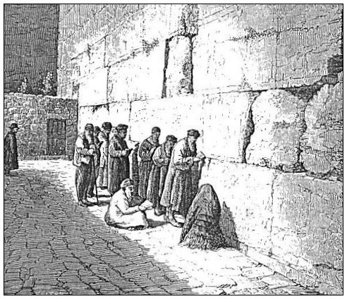 |
| THE JEWS' WAILING-PLACE. |
No doubt many of these unhappy people mourn as much over their individual sorrows as over the national calamities of which they read; but that there is much genuine lamentation among them is attested by all travelers who have witnessed the scene. When the author was there, out of the two or three hundred persons present, much the [188] greater part appeared to be deeply absorbed in the services which had brought them together, and many of both sexes were weeping freely, with streams of tears flowing down their cheeks. They still look forward to the coming of the Messiah and the restoration of the kingdom of David, and they continue to offer prayers that cannot be heard because they are not offered in the only name by which man can now draw near to God. They pray, too, for that which has already been given them and rejected, under the mistaken belief that it is yet to come. It is hard to conceive of earnest souls in a more pitiable condition.
§ VIII.
THE POOLS OF JERUSALEM.
Although the private cisterns and public reservoirs and wells of Jerusalem afford a sufficient supply of water for all necessary purposes, its supply in ancient times was far greater than at present; for several of its capacious pools once in use are now entirely dry, and others are supplied with much less water than formerly. We will speak first of those which have a perennial supply of water.
The only known perennial fountain within the hills on which the city stands is the so-called Virgin's Pool, in the eastern side of Ophel. You reach it by following the Kedron Valley southward till you are about 300 yards below the southeast corner of the har'am. The entrance to it is only 5 feet above the bed of the valley, which is here a narrow ravine. The pool lies deep within the hill and under it. In approaching it you first go down a flight of steps 8 feet wide, which are exposed to the sky, and whose perpendicular descent is 16 feet 8 inches. At the foot of this flight of steps you enter a vaulted chamber 8½ feet wide by about 20 feet long, and after advancing 13 feet you reach another flight of steps cut in the natural rock, 4½ feet wide, whose perpendicular descent is 13 feet 3 inches. The last step of this flight is nearly on a level with the water. Thus the entire descent to the surface of the water is about 30 feet, and the distance westward into the hill is more than 40 feet. The pool itself is shaped very much like the longitudinal section of a jug. The neck, which is next to you, is from 3 to 4 feet wide; the widest part of the pool is about 9 feet; and the entire length of it 21 feet 9 inches. The water stands in it about 3 feet deep, and the rock ceiling is only 4 or 5 feet above the water. It is supplied by an intermitting stream which enters it under the northern end of the bottom step, and which descends from [189] an unknown source in the more northern part of the mountain. It flows sometimes two or three times a day, and sometimes only once in two or three days; and the flow continues from fifteen to thirty minutes. A conduit, 2 feet wide and from 3 to 15 feet high, excavated through the bowels of the hill for a distance of 1750 feet south to the Pool of Siloam, conveys the surplus of its water to that pool. This
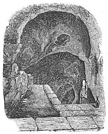 |
| ENTRANCE TO THE VIRGIN'S POOL. |
passage was first explored by Dr. Robinson, and afterwards by Captain Warren.73 Its windings are such that it runs 1750 feet in reaching a distance in a straight line of 1200 feet.
The intermitting flow, which is a great mystery to the Arabs, is undoubtedly caused by a syphon in the direction of the source; but the source has not yet been discovered. Dr. Robinson conjectures that this is the pool called Bethesda in the New Testament, and that its intermitting flow was mistaken by the superstitious people for the action of an angel descending into the water at intervals and agitating [190] it.74 Conder thinks, with far less show of reason, that it is the Upper Gihon of the Old Testament; and he supposes that the conduit is the one made by Hezekiah and mentioned in 2 Kings xx. 20. He says, as do other travelers, that the people of the vicinity still credit the water with healing virtue, and that many go there every day to bathe. The author saw both men and boys bathing in it, while others were filling skins with the water to be taken away, and some were drinking it. The steps were wet and slippery, and much personal filth was seen on the steps and on the floor of the vaulted chamber. It is said that the water has a sweetish taste, but we did not choose to put
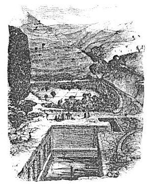 |
| POOL OF SILOAM AND GARDEN BELOW. |
The Pool of Siloam is situated near the foot of Ophel, on its western slope, and consequently near the mouth of the Tyropeon Valley. That it is the same pool known under this name in the New Testament, is evident from the fact that Josephus locates the Siloam of that period in the identical place occupied by the present pool.75 It is 50 feet long, 14½ wide at its southern end, and 17 at its northern.76 Its wall is built up 18½ feet from the bottom, and at present the accumulation of rubbish about it is such that a steep mound ascends from its wall on all sides, rendering it somewhat difficult of access. A flight of stone steps, four feet wide, descends into it at the southwest corner, a broken column, five or six feet high, stands in the middle of it, and six [191] columns are half buried in its western wall. These are remains of a church which was built over the pool in the year 600, and of a monastery which took its place in the twelfth century.77 The water enters its upper end through the aqueduct from the Virgin's Pool mentioned above, and it has two outlets at the lower end by orifices through the wall,--one on a level with the bottom and one three or four feet above the bottom. When the former is open the water passes through the pool in a small stream; when it is closed it accumulates to a depth of from three to four feet, and in either case the surplus is led by a channel, at first underground and after a few rods on the surface, to some vegetable-gardens in the Valley of the Kedron, which are irrigated by it. The soil of these gardens is very rich, and their vegetation luxuriant. This is the pool to which the blind man was sent by Jesus to wash his eyes that he might see.78 Before the present accumulation of rubbish about it, it was an admirable place for baptizing, and Mr. El Kary, a Baptist missionary in Shechem, informed the author that he was baptized in it twenty-five years ago.
A short distance below the Pool of Siloam, the road descending the Valley of Jehoshaphat unites with that descending the Valley of Hinnom, and a short distance below this point you reach the only unfailing well about Jerusalem. It was known in the Old Testament, and in the writings of the earliest Christian travelers, as En-Rogel; but since the Mohammedan invasion it has been called by the Arabs the Well of Job, and by some the Well of Joab. Since the sixteenth century the Greek and Latin priests in Jerusalem have called it the Well of Nehemiah, from a tradition mentioned in 2 Mac. i. 19-22, that in a chamber connected with it the holy fire of the altar was concealed during the Babylonian captivity, and found there by Nehemiah.
The surface of the ground at this well is 345 feet lower than that of the har'am area, and the well, according to Barclay's measurement, is 124 feet deep. It is a very large well, though its mouth is narrow, and a stone cast in produces a reverberation when it strikes the water as if thrown into a large cavern. A small and rude stone building stands over it, in the rear of which you gain access to its mouth. It has not been explored by the modern traveler, and little is known of its internal structure. In the winter it frequently overflows, and sends a lively stream down the valley. In summer its water becomes low sometimes, but it never fails. Dr. Barclay relates that in September, 1853, when the cisterns and tanks within the city were generally exhausted, [192] about 2000 donkey-loads of water, amounting to 25,000 gallons, were daily carried in skins into the city from this well, yet this heavy draught, though continued more than a month, reduced the water only to 6½ feet, and it promptly came back to 21 feet when the first rains of November put a little water into the exhausted cisterns in the city.79
The antiquity of this invaluable well is attested by the fact that it was one of the landmarks on the line between Judah and Benjamin in the days of Joshua,80 and it possesses historical interest from its connection with David's unhappy flight from Absalom, and with Adonijah's rebellion.81
The visitor to this well at the present day is sure to meet a dozen or more of the wretched lepers of Jerusalem, for whom a house has been constructed by the contributions of the charitable about a hundred yards below the well, in which they are now compelled to reside. Formerly they were confined within a certain quarter of Jerusalem. Their importunities for charity are so piteous as to be irresistible.
We now pass to the consideration of those pools which are supplied by the surface-drain. Returning from En-Rogel back to the junction of the two valleys, and taking the road turning to the left, which leads up the Valley of Hinnom, we pass up that valley, hugging its northern side along the foot of Mount Zion, until we reach the southwestern curve of that hill, and thence northward, hugging its western side, till we reach a massive wall built across the valley, which is the southern end of the pool called Lower Gihon. You are now nearly in line with the southern wall of the city on Mount Zion, and about midway the length of that mount from north to south. The locality is indicated in the cut on page 165, in which you are looking up the Valley of Gihon along the western side of Mount Zion. The small building in the centre of the cut stands on the southern wall of the pool.
The southern wall of the pool is 275 feet long, and is built on the solid rock of the valley, which slopes down gradually from each side. From the top of the wall in the middle to the rock in the bottom of the valley is 50 feet. Within 8 feet of the bottom on the upper side is a strengthening wall, 7½ feet thick, which forms a broad step,82 and [193] from this rises another 6 feet high and 2 feet thick. The thickness of the wall at the top is 25 feet, but on the lower side it is strengthened in the middle by a buttress 25 feet long and 23 feet wide. In this part, where the pressure of the enormous mass of water was greatest, the entire thickness of the wall at the top is 48 feet. Add to this 9½ feet of the two buttresses on the upper side near the bottom, and we have an aggregate thickness at bottom of 57½ feet. On the upper side of the wall was a coat of cement 3½ inches thick, some of which is still to be seen near the base, though it is all gone from the upper part. When the cement was entire no water could pass through the wall, and if any which lodged against it escaped it was by falling over the top of the dam. If the cement were now in good condition the pool would be filled with water in the rainy season.
The upper end of the pool is formed by another wall across the valley, of moderate thickness, 35 feet high in the middle and 245 feet in length. The distance between the two, measured along the middle of the valley, and marking the average length of the pool, is 592 feet. The sides of the pool are marked by walls connecting the ends of these two end-walls. These are built on ledges so high up the sides of the valley that, although they are on a level with the two end-walls, they are only from four to six feet high. The bed of the pool consists of the shelving rock of the two sides and bottom of the valley, which, as in most valleys of the kind, lies in layers from two to three feet thick, forming steps of irregular width, in many places eight or ten feet wide. The pool, as the figures given above show, is 30 feet wider at the lower end than at the upper, its average width being 260 feet. The valley above the upper wall is filled with earth to a level with the top of this wall, so that the surface water in a heavy rain runs over that wall as over a mill-dam into the pool. The entire area of this pool is about 3½ acres, with an average depth, when clear of deposit, of 42½ feet in the middle from end to end. It would seem almost sufficient in itself to supply all the wants of the city, for which its waters would be suited, and it was so close under the original wall of Mount Zion that it could be protected from an enemy outside. If this pool is mentioned in the Scriptures at all, it is the one called "the lower pool" in Isaiah xxii. 9: "Ye gathered together the waters of the lower pool." This appellation suits its relative location better than any other known pool. Lieutenant Conder83 advances the opinion that it was constructed by the Germans in the twelfth century, but there is no foundation for [194] this opinion except the fact that among the Crusaders it was called Germanus. But Baedeker accounts for this name in a different way. In speaking of it he says: "In the time of the Franks it was called Germanus, in memory of the Crusader who discovered Job's well. It was remodeled at that period, and in the second half of the sixteenth century it was restored by Sultan Soliman, whence its present name."84 Its present name among the Ar'abs is Pool of the Sultan. It has been called by Christians Lower Gihon ever since the fourteenth century.
The author can see no ground for doubting that this pool belongs to the ancient Jewish period. The construction of such pools was characteristic of the ancient Jews, the entire hill country abounding in them, and there is no evidence that any at all were constructed by the Crusaders. The neglect of these admirable reservoirs and their gradual ruin has been the rule since the Jews were expelled, and not the construction of new ones.
The history of such pools as this has an important bearing on the question of the ancient population of Jerusalem. The fact that they have been allowed to go into decay shows that during the period of their decay the water supply of Jerusalem has been sufficient for its population without them; if it had not, this circumstance would have necessitated their preservation. But the present water supply was not sufficient for ancient Jerusalem, or these additional reservoirs would not have been constructed. Economical and far-seeing men like the ancient Jews do not expend vast sums of money, or undergo herculean labor, for works like this when they are not needed. It follows, then, as an unavoidable conclusion, that the population of Jerusalem in ancient times was greater than it has been in modern times. Nor does the argument stop here; for the addition made to the water supply of this and other great reservoirs was immense, far transcending the supply from all other sources. This argues the existence, at the time these works were made, of not only a greater, but an immensely greater population than is found in the modern city. Thus, everything pertaining to the antiquities of this wonderful city tends to confirm the Biblical account of its importance and extent during the period of Israel's prosperity, and to strikingly illustrate those passages in the prophetic books that foretold the ruin which God would bring upon it.
The pool called Upper Gihon by Christians, and Bîrket el Mamilla [195] by the Ar'abs, is situated 735 yards due west of the Joppa gate. It receives the surface-drain from the west and north, over a space varying in width from a quarter to a half mile. It is 316 feet long, measured on the northern wall, and 218 wide, measured on the eastern wall; and its depth, measured at three different places, is 19, 20, and 22 feet, the average being about 20.85 Its bottom is the natural rock, but hidden with mud and small stones, and its walls are of well-built
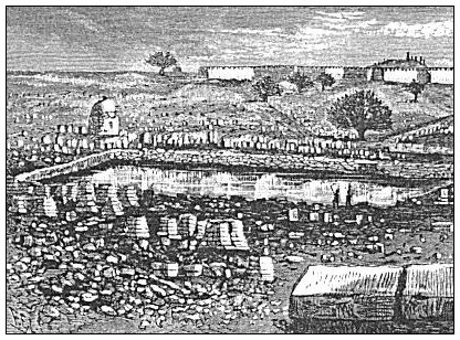 |
| UPPER POOL OF GIHON. |
masonry, lined with cement. The walls are now crumbling in places, and the cement remains only in patches There is a flight of stone steps at the southwest corner 5½ feet wide, and one at the southeast corner 7 feet wide. The steps are much broken and worn, yet it is easy to descend them to the bottom of the pool. Traces of similar flights at the other two corners are distinctly visible. At the east end of the pool, and at the present bottom, there is a square opening [196] through the masonry 20 inches each way, which leads into an aqueduct running thence underground towards the city, and on the surface about 30 feet east of the pool there is an opening into a vaulted passage, with a narrow flight of steps descending to this point. The aqueduct, when open, would keep the pool drained to its own level, and this narrow flight of steps was evidently used to obtain access to the mouth of the aqueduct, and close it when it was desirable to let the pool fill up, or open it when it was desirable to drain it. This aqueduct, as it approaches the city, comes to the surface, and passes along the side of the road leading to the Joppa gate, with only a covering of stone slabs, but when it reaches the higher ground near that gate it disappears under ground, passing under the wall north of the gate, and thence into the Pool of Hezekiah. By means of it the Pool of Gihon may be entirely drained into that of Hezekiah, and this is done whenever the supply of water is not sufficient for both. Such was the case in the spring of 1879; but the Upper Gihon is usually full of water after winters in which there is the usual rainfall, and it does not become dry until late in the summer. It is supposed to be the upper pool mentioned in the history of Hezekiah's reign, and the conduit just mentioned to be the "conduit of the upper pool."86 It is used as a swim-pool by the men and boys of the city. The entire open space round about it is covered with the rude slabs of a Mohammedan burying-ground, each slab covering the top of a grave; and thither almost every morning of the year, about sunrise, groups of women, wrapped in white sheets, resort to visit their dead. The road from the pool to the Joppa gate passes along a shelf, with the Joppa road to the left about 40 feet higher but gradually descending until they meet at the gate. The Valley of Gihon lies to the right, heading near the pool, and gradually deepening as it approaches the city. It makes an abrupt turn to the south near the gate, where it is about 40 feet below the road. The roadside along the verge of the valley is protected most of the way by a retaining wall.
In the northwest angle between David Street and Christian Street, lies the Pool of Hezekiah, the southern end of it being separated from David Street by the block of houses just below the Mediterranean Hotel, and the eastern side separated from Christian Street by the small houses on the left, as you pass up that street. It is entirely surrounded by houses. The best view of it, and the one most accessible to travelers, is from a flat roof over a portion of the hotel, whose wall [197] is part of the wall of the pool. It is 240 feet long from south to north, and 144 feet wide. Its bottom is about 10 feet below the level of Christian Street, but as the walls of the surrounding houses are but a
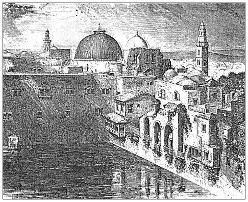 |
| POOL OF HEZEKIAH FROM THE HOTEL ROOF. |
continuation of its wall, it might be filled with water to a greater depth than this. It is deeper at the southern than at the northern end. The Coptic Convent, whose almost solid wall is seen in the cut, extends entirely across its northern end, and through a door from this building, opening upon a flight of steps four feet wide, is the only access to the pool. Water is drawn from it in buckets let down by ropes through openings in the walls of the houses. The water is chiefly used for bathing purposes, and a public bathing-place on Christian Street, called the Patriarch's bath, is supplied with water from it. It usually holds water all through the summer, but it sometimes goes dry. Mr. Hornstein, proprietor of the hotel, who has resided in the city for more than twenty years, told the author that this occurs but very rarely, though it occurred in the summer of 1876. As we have stated above, page 197, its supply of water is derived from the Upper Gihon by an aqueduct proceeding from the present bottom of that pool. Mr. [198] Hornstein informed the author that when excavations were being made for the erection of his hotel, he saw this aqueduct near its entrance into the pool, and heard the water flowing through it. It is called the Pool of Hezekiah, from the supposition that it is the one constructed by this king. It corresponds to the account in the sacred text, which says, "The rest of the acts of Hezekiah, and all his might, and how he made a pool, and a conduit, and brought water into the city, are they not written in the book of the chronicles of the kings of Judah?"87 and it appears to the author that no sufficient ground for doubting that it is the same has been advanced. It is mentioned by Josephus under the name Amygdalon (tower-pool), which shows that, although in his day it had not received the name of Hezekiah, it was already in existence. It also corresponds to the statement in 2 Chron. xxxii. 30, which states that Hezekiah "stopped the upper water-course of Gihon, and brought it straight down to the west side of the city of David." If we are right in locating the city of David (see page 144), these words can apply to no other than the upper Pool of Gihon, and the conduit which to the present day brings its waters "straight down to the west side of the city of David." That he stopped the previous water-course in order to effect this change shows that the surplus water from the pool had escaped in some other direction. The criticism by Conder, based on the meaning of the term Gihon, "springhead," is not sufficient to set aside the force of this evidence; for there may have been originally a spring where the pool now is, or the pool, being a source of supply to its conduit, might have been called Gihon by an accommodation of the term.
The pool which for some generations has been called Bethesda by the monks of Jerusalem, but Bîrket Israil (Pool of Israel) by the Ar'abs, is situated immediately north of the har'am, the northern wall of the latter resting on the southern wall of the pool. The eastern end of the pool extends so near the east wall of the city running south from Stephen's gate as to leave only a narrow street between. Thence it extends westward 360 feet, filling the space between the Via Dolorosa and the har'am wall, and throughout this length it maintains a width of 126 feet. Its northern wall rises 6 feet above the surface of the Via Dolorosa, thus guarding the southern side of that street. At the southwest corner of the pool it is extended 124 feet farther westward in two vaulted passages whose aggregate width is 42 feet.88 They [199] pass under the buildings connected with the Turkish barracks. We may say, then, that the main body of this pool is 360 by 130 feet, and that it has a neck 124 by 42 feet. Its entire area is 5853 yards, nearly 1/5 acres. Its depth, as ascertained by Captain Warren, is 80 feet, and he found at the eastern end, 25 feet from the bottom, a circular opening through the wall, which he supposes to be an overflow duct, intended, when open, to prevent the water from accumulating to a depth of over 25 feet. He found also a staircase descending into it from the har'am area through a rock-cut passage, which he thinks was intended for the use of soldiers in a time of siege, giving them access to the water without exposing them to the view of the enemy outside. The bottom was found by Warren in a complete state of preservation, but he represents it as covered with rubbish 35 feet deep. It is the common reservoir for all kinds of trash and filth removed from the houses and streets of that part of the city, and when the writer saw it in 1879 the mound of this stuff was level with the wall near the northeastern corner. All of the water which pours into it during the winter is absorbed by this filth, and it becomes a reeking mass of corruption, which doubtless breeds much disease. To the shame of the Turkish authorities, it is said that Mr. Maudsley, an English gentleman of fortune, proposed a few years ago to clean out and restore the pool at his own expense, but they refused permission.89 He hoped not only to make it useful, but to discover its original source of water supply. It evidently served the double purpose of a reservoir for water and of an impassable moat to protect the northern wall of the temple. Captain Warren discovered by his excavations that it occupies a deep and narrow depression in the natural rock between Beze'tha and the temple area, which begins at the western end of the barracks, and extends eastward into the Valley of the Kedron. How this pool was originally supplied with water is one of the unanswered questions connected with this curious city. It will probably be found that its supply came from the aqueduct which brought water from the fountain at Solomon's pools, and reached it by some connection hidden beneath the surface of the har'am. Dr. Robinson was the first explorer to call in question the tradition that this is the Pool of Bethesda mentioned in the fifth chapter of John, and to suggest that the true Bethesda is the pool now called the Virgin's (see page 189). Since then the majority of careful explorers have agreed with him in denying the name to this large pool, though they advance conflicting theories as to the true Bethesda. It [200] appears altogether unlikely that a pool as deep as this, with no appearance of steps leading into it, can have been the one into which the cripple wished to plunge, and in which some diseased person plunged at every disturbance of the water. And inasmuch as the statement that an angel went into the water and troubled it, after which the first person entering was healed, is now known to be an interpolation in the text of John, we must look for some natural cause of disturbance which the superstitious crowd mistook for this; and such a cause is the intermittent flow of the Virgin's Pool. The pool Bîrket Israil is not mentioned in the Scriptures, and consequently it has no Scriptural name.
Outside the wall of Beze'tha, and 250 feet north of Stephen's gate, is a pool, called by the natives Bîrket Sitti Mariam, Pool of Lady Mary, i. e., the Virgin Mary. It has no Biblical history. It is 100 feet long from north to south, 85 feet wide, and 27½ deep. There were 2½ feet of water in it when seen by the author. It has a flight of steps at the southeast corner, and at the southwest corner there is a place for drawing water by machinery, and a channel to lead it through the wall into the city. It appears to have been supplied with water by the drainage of the broad fosse which extends along the base of the wall as far as the northeast corner of the city, a distance of 764 feet, and which has a gradual descent toward the pool.
Close to the northern wall of the city, between Herod's gate and the northeast angle of the wall, is a pool about forty feet square and ten feet deep, more than half of which is arched over and covered with earth above the arch. In one corner of the part that is exposed to the sun is a passage-way by which animals can descend to drink of the water, and the water was about three feet deep when seen by the author. It has been sometimes called Jeremiah's Pool, from the conceit that it is the dungeon in which Jeremiah was imprisoned,90 but the conceit is too absurd to be considered seriously by any one acquainted with Jeremiah's history. It is known as Bîrket el Hijjeh.
There are other small pools and tanks about the city which should be mentioned in a minute account of its means of preserving water, but those mentioned above are sufficient for the purpose of this work.
Besides these reservoirs for storing the water derived from the surface drain and from fountains, under almost every building of any importance in the city there are one or more cisterns which receive the water from the roof and court of the same; and many of these are of large dimensions. Dr. Barclay states that the water in these is cool [201] and pleasant, and that it usually exists in sufficient quantity to supply all the wants of the family;91 and Dr. Robinson states that under a house in which he found lodging while in the city there were four cisterns, one of which was thirty feet square and twenty feet deep. He remarks that this is a fair specimen of the way in which houses of the better class are supplied.92 The author can testify to the fine quality of at least some of the cistern water of the city, for he drank from a cistern in the portico of the Armenian Church of St. James a draught of as pure and refreshing water as he ever tasted. There is no doubt, however, that many of the ancient cisterns, for want of proper attention, have received such an accumulation of filth as to render their water impure and unhealthy.
§ IX.
THE ENVIRONS OF JERUSALEM.
The Western Suburbs.--If you leave the Joppa gate and follow the Joppa road, which is the only macadamized road in Palestine, you pass on your right a row of one-story shops, cafés,93 and dwellings, which extends as far as the northwest angle of the city wall, your road thus far being nearly parallel with the wall. On reaching this point you see a road turning to the right, with a row of buildings on its right-hand side, and the wall surrounding the Russian property on its left. Avoiding this road and passing on you have the southern wall of the Russian property, a well-built wall of white limestone about twelve feet high, on your right, and an almost continuous succession of dwelling-houses on your left. Neat and new residences, many of them with yards in front, after the European style, and all separated by stone fences, continue to line both sides of the road for nearly a mile, and to stretch away for nearly a half-mile to the right and the left.
If on leaving the Joppa gate you take the Bethlehem road, you go due south for about 200 yards, descending the side of the Valley of Gihon, and then turning west you cross this valley on a bridge supported by small arches. The valley is filled up at this point so much that the piers of these arches are hidden, and only the arches themselves are visible above the ground. As you ride across you observe a wall about three feet high, like a parapet-wall, along the upper edge of the [202] bridge. Along its top runs the earthenware aqueduct from Solomon's Pools.
After crossing the bridge just described you turn southward again and pass along the front of a row of beautiful stone cottages, built in European style, with a continuous iron veranda in front, a continuous succession of small yards, and a good stone fence next to the road. The row is really one continuous building divided into twenty-eight tenements. Back of this row, and higher up the hill, is another of the same style, containing six tenements. Back of these, again, and on the summit of the ridge, is a windmill belonging to the same property. Some ten or fifteen acres of ground about these buildings are inclosed with a new and well-built stone fence, and vines and trees are beginning to show themselves in the unoccupied spaces. It is all the property of Sir Moses Montefiore, a rich Jew of London, now of extreme old age, who furnishes the tenements free of charge to poor Jews of the city. Two other windmills belonging to other parties crown the same ridge, and all of the slope between this property and the Joppa road, except the graveyard about the Pool of Gihon, is thickly dotted with new dwellings.
The Russian property, of which we spoke above, consists of some twenty-five or thirty acres of ground surrounded with a strong wall twelve feet high, entered by massive gates, and containing a large number of new and well-constructed buildings for the accommodation of priests, pilgrims, and the officials of the Russian government. There is a hospital for men, and one for women; a hospice, or lodging-place for pilgrims, capable of lodging one thousand persons; a consul's palace; a fine church; and a residence for the priests. These immense possessions held by the Czar are looked upon with jealousy by other European powers, especially by Great Britain.
The northern suburbs contain almost as many buildings as the western, and among them are some of the most attractive structures about the city. Among these are a beautiful chapel and parsonage belonging to the English Church, and a row of nearly one hundred tenements recently built by European Jews, and not yet finished. All of these buildings, both on the northern and the western sides of the city, are a growth of the last ten years. Previous to that time it was considered unsafe to dwell outside the walls of the city; but the increased security of the country, brought about largely through the influence of the European consuls, together with a large influx of Jewish population, and an increase of the missionary zeal of European Christians, has caused to spring up this new Jerusalem outside the walls of the old. The result has [203] demonstrated the inutility of the ancient walls; and if this prosperity shall continue without a serious check, it is probable that ere long the useless walls will be turned into a supply of building-stones for the growing city, and be made to yield a little revenue to the impoverished treasury of Turkey. The health and comfort of the city would be promoted by the change, though much of the novelty of a visit to it would be taken away.
As you pass out of the Damascus gate, going north, you have two mounds on your right and left, each about 30 feet high, built of ashes and rubbish of every kind brought out of the city and heaped up until the process was discontinued to save the road from being obstructed. They are partly seen in the cut on page 159. The road ascends gradually from the gate, and just beyond the mounds it passes on the left some shops for the manufacture of articles in olive-wood. On the right, opposite the shops, is a ridge of rock 30 or 40 feet high, partly covered with Mohammedan graves. It has a perpendicular face toward the south, which is pierced by the mouth of a cavern called Jeremiah's Grotto. Beyond this, on the right of the road, you pass newly-built houses and inclosed grounds, and on your left a large grove of olive-trees, covering some forty or more acres, and reminding you of a large orchard of old and half-decayed apple-trees. This is the only grove in the vicinity of the city. It is unfenced, and it is the resort, on pleasant mornings, holidays, and Sabbaths, of large numbers of men, women, and children from the city, who come here to enjoy the fresh air, and to eat and drink in a social way. On Friday, the Mohammedan Sabbath, it is frequented chiefly by Turks and Arabs; on Saturday, the Jewish Sabbath, by Jews; and on Sunday, by the Greek and Latin Christians. The shade of the olive-tree is thin, but better than none.
About a mile north of the Damascus gate, and on the right-hand side of the road, are the so-called Tombs of the Kings, described above in Chapter VI., § VII. Until recently they were in the open country and unprotected, but now a good stone wall incloses about an acre of ground about them, a strong gate guards the entrance, and an attendant occupying a small house inside takes care of the premises. The expense of this improvement was met by a French Jewess, and an annuity contributed by her meets the current expense. All visitors are admitted without a fee.
Somewhat more than a mile northwest of these tombs are the so-called Tombs of the Judges, also described in the chapter and section just referred to. The rock about their entrance has crumbled much, and [204] much earth has washed into them. They are in the midst of a multitude of inferior tombs; and, indeed, all of the rock on this side of the city at all suitable for the purpose is perforated with ancient sepulchres.
After passing out through the Damascus gate you can follow a road which turns square to the left, and pass along the wall to the northwest corner of the city, and thence to the Joppa gate,--a better route than to ride through the city; or you can turn abruptly to the right and follow a well-beaten road to the northeast corner of the city. In doing so you ride through a cut in the Beze'tha hill, with the perpendicular rock on your left containing Jeremiah's Grotto, and the corresponding rock on the right supporting the city wall. An opening in the latter rock, just above the surface of the ground, is the entrance to Barclay's Quarry, commonly called the Cotton Grotto. The entrance is now closed by a wooden door. It is an immense cavern, running under the Beze'tha hill and undermining the houses of the Turkish quarter. It was first discovered in modern times by Dr. Barclay. As he was passing along the road one day his dog, attracted by the scent of some animal which had burrowed in the mouth of the cave, commenced scratching at the spot, when he suddenly dropped in and disappeared. He soon came back, but his master, suspecting that some interesting discovery might be made here, but anticipating interference if he attempted an excavation in the daytime, went out of the city one afternoon with two of his sons, allowed himself to be shut out by the closing of the gates, and then, with lights and spades, effected an entrance and explored the cavern. He reported it as more than 3000 feet in circumference and 750 long.94 The author measured from its most remote corner by the most direct route to the door, and found the distance 812 feet, but not by an entirely straight line. It runs in a southeastern direction toward the temple mount, but it extends very irregularly in various directions. Its floor, also, is very uneven, and the height of the ceiling varies from 10 to 30 feet. In many places there are mounds of chippings made in quarrying blocks of stone. Piers are left at irregular intervals to support the ceiling. In one place a very large mass of rock has fallen from the ceiling, while other masses seem ready to fall, and our guide cautioned us against passing under them. On the perpendicular sides are seen in places large stones but partly cut away, and the marks of the chisels are as plainly seen as if the cutting was made but yesterday. In a kind of pit, about 15 feet deep and nearly 100 feet across, with a perpendicular side, Dr. Barclay [205] found the skeleton of a man, who may have fallen there and broken his neck. A feeble spring of impure water, which trickles from above, is found near the remotest part. The rock is a soft, white limestone, such as is found in the walls of many houses in the city, and in some parts of the city wall. I think the conjecture that here the large stones of the temple and its substructions were quarried is erroneous, for the rock is not sufficiently hard and durable for this purpose, and the really ancient stones now visible in the temple wall are of a harder variety of limestone. Mr. Robert Morris, an American Freemason, who visited Palestine in the year 1874, reports that he gathered together the adherents of his order whom he found in Jerusalem, and went through the process of organizing a Freemason's lodge in this quarry.
Resuming our ride toward the northeast corner of the city, we next pass on our left a garden wall inclosing several acres of ground about a substantial private residence, and on reaching the brow of the hill descending into the Kedron Valley our road forks, one fork turning south and running parallel with the eastern wall of the city toward St. Stephen's gate, and the other turning to the northeast and descending into the upper part of the Kedron Valley. The valley, where this road enters it, spreads out into a beautiful little plain, with gardens, patches of grain, and olive-trees covering its surface. From its northern side rises the hill called Sco'pus, a rocky ridge, higher than the highest part of the city, lying about a mile from it, and extending for several miles east and west. It also curves round toward the south with the northeastern curve of the Kedron Valley, and after extending southward a short distance it breaks down to a low saddle connecting it with the northern end of the Mount of Olives. The road just mentioned by which we descend into the valley ascends to the top of this saddle, and thence ascends the northern end of the Mount of Olives.
If you pass out the city through St. Stephen's gate you may ride along the wall either north or south, but the most frequented route is straight before you into the Kedron Valley, which is here much narrower than above and immediately below. The slope down into it is too steep for the road to descend directly, so it makes an angle to the left and then to the right to secure an easier grade. Neither does the road descend to the bottom of the valley; it crosses on a stone bridge whose arch, about 10 feet high, spans the torrent-bed at the bottom. Just before crossing the bridge you pass the traditional spot of the stoning of Stephen, which is about as likely to have been the real spot as a hundred others near by, and no more so. Soon after crossing [206] the bridge you see on your left the entrance to the "Tomb of the Virgin Mary." This is a chapel deep down below the surface of the rock. On leaving the road you descend several flights of steps to an open space in front of the chapel, where you are 15 or 20 feet below the road. Then you enter the door and descend a very broad flight of steps, which bring you 35 feet below the surface. In descending you pass the tomb of Joseph on your left, and that of Anna and Joachim, the reputed mother and father of Mary, on your right. The chapel is a long and narrow vault, about 30 yards long by 6 wide, and is hung with silver lamps, which light up a Greek altar, where services are held daily by Greek priests. A sarcophagus is shown which contains the bones of Mary, and a well in one corner furnishes you a drink of cool water. After carelessly looking around upon the objects pointed out, you return to daylight with a feeling of pity mingled with disgust at the easy credulity and superstition which thus lavish money and time upon the purely imaginary burial-place of a woman, concerning whose death and burial the most that any man can now know is, that she must have died and that she probably received a decent burial. The little building covering the entrance to this tomb is the first on the left of the road in our cut of the Mount of Olives, opposite page 208.
After returning to the road and resuming your progress eastward, a few more steps bring you to the wall of the traditional Garden of Gethsemane. (See it in the cut.) At the corner of this inclosure the road forks, the principal track passing to the right and running for some distance almost due south along the base of the Mount of Olives, while the other turns to the left and begins to ascend the slope of the mount along the northern end of the garden. The garden wall is a well-built and fresh-looking wall of limestone, about 10 feet high, plastered and whitewashed. When you reach the northeast corner of the inclosure, where a small one-story building occupies the angle of the wall, you turn to the right and pass to the far end of the eastern wall to gain admittance. Here a grated iron door is opened at your call, and you are admitted to a free examination of all within. The inclosure is nearly square, and it includes about half an acre of ground. It is divided by light picket-fences into six squares, all of which are prettily laid off and cultivated in flowers of many varieties. A well near the centre affords water for irrigation, which is conveyed in pipes to every part of the garden. Around the inner face of the wall, on the northern, western, and southern sides, are fourteen rude paintings, representing the fourteen stations, as they are called, of Jesus on his way [207] from Pilate's hall to the cross and the sepulchre. They are the same that are pointed out by the monks along the Via Dolorosa and in the Holy Sepulchre Church.95 A gravel walk, about five feet wide, passes around between the wall and the garden fence to enable visitors to examine these pictures. The only objects within the garden which now remind you of Gethsemane are eight very venerable olive-trees, whose immense trunks, gnarled and twisted and full of cavities, and whose scanty foliage at once proclaim them very old trees. One of them is correctly represented by the cut opposite page 56. The largest is 24 feet in circumference, and the next in size 21 feet, measured above the swell of the roots. It is scarcely possible that these trees date back to the time of Jesus; but the word Gethsemane means oil press, and the garden of the oil press must have had olive-trees within it or near it. Under trees quite similar to these, in fact the predecessors of these, the Saviour's great agony occurred. The modern improvements, though very pleasing to the eye, detract very much from the impression which the spot would otherwise make upon the mind and heart.
There is, of course, no certainty that this garden occupies the identical spot of the real Gethsemane, but it cannot be very far from the real spot; and its venerable olives, the like of which are not elsewhere seen in the vicinity of Jerusalem, render it more suggestive of the ancient associations than any other adjacent spot. The ground belongs to the Latin Church, and is in the care of the Franciscan monks, by whom it is cultivated, and who built the present wall around it in the year 1847. It has been regarded as the site of Gethsemane ever since the fourth century. The Greek Church, through sectarian rivalry, has recently fixed upon another spot, a hundred yards or more to the northeast of this, as Gethsemane, and has there built a wall around a smaller inclosure. It is seen in the opposite cut of the Mount of Olives.
No locality about Jerusalem is more familiar to the Bible-reader, by name at least, than the Mount of Olives. It is a high ridge running parallel with Mount Moriah, and separated from it only by the narrow valley of the Kedron. Its length from south to north is about the same as that from the southern end of Ophel to the northern end of the Beze'tha hill, and it presents, as viewed from the city, a smooth side with a steep slope. Its summit is 207 feet higher than the temple area, and the distance between the two points, measured in a straight line down one hill and up the other, is about half a mile. At its northern [208]
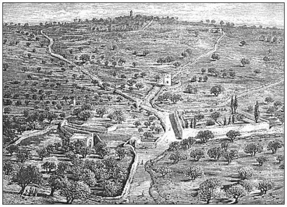 | ||
| MARY'S TOMB. | MOUNT OF OLIVES. | GARDEN OF GETHSEMANE. |
| Page 208. | ||
extremity it breaks down nearly a hundred feet to a saddle connecting it with the hill called Sco'pus, which sweeps around to the north of the city,96 and at its southern end it falls a little lower still to a saddle connecting it with the eminence called the Hill of Evil Counsel.
The ascent of the mount is made from the Garden of Gethsemane by three paths which part just above the garden, one ascending almost directly to the summit, one inclining to the right, and the other to the left. Each of the latter two, by its inclination, secures an easier ascent, but all three routes are practicable on horseback. (They are seen in the cut.) On the central part of the summit are the remains of the so-called Church of the Ascension, the original of which was erected by the Emperor Constantine in the fourth century. It is now almost in ruins, and back of it is a village composed of a few miserable huts occupied by a loathsome set of Ar'abs. In the middle of the court, around which the old structure is built, is a small octagonal chapel, about 20 feet in diameter, with a dome over it, on whose stone floor there is a depression in the rock said to have been made by the feet of Jesus as he took his last step before ascending up to heaven. It is surrounded by a wooden frame and covered with glass, and it is a very sacred spot with the superstitious pilgrims.
This old church, like nearly all others in Palestine, was turned by the Moslem into a mosque, and on its western front still stands an old minaret, which travelers are permitted, for a small fee, to ascend. From its balcony is obtained the very best view of Jerusalem, the one presented in the frontispiece to this book. The city spreads out like a map before you, all being from 100 to 200 feet below you, and sloping toward you. Every conspicuous building in the whole city and its suburbs is distinctly seen, and you can trace all the elevations and depressions of the surface both within and without. It was not far from this spot that Jesus stood when he looked upon the city and bewailed its impending doom; and he must have been seated somewhere near it when he so fully described to four of his disciples the same sad event with its preceding signs.97 Beyond the city, a few miles to the northwest, rises Neby Samwil (Mizpeh), lifting the minaret of its ruined mosque high above every other point in the horizon, while to the southwest the horizon is bounded by long, swelling ridges, higher than the mount on which you stand. To the south the ridges about Bethlehem are seen, though the city is not, while the most conspicuous object in that direction is the conical "Frank Mountain," whose [209] truncated top was the burial-place of Herod the Great. To the southeast the horizon is bounded by the dark-purple wall of the Moab Mountains, at the base of which is seen a section of the northern extremity of the Dead Sea and a portion of the southern end of the Jordan Plain. Along the latter is a winding line of dark verdure, marking the course of the Jordan, but its waters are not visible. You can see at a glance that these objects are deep down below where you stand, and that even the summit of the Moab Ridge is below you. Although the farther shore of the Dead Sea is fully twenty-five miles distant in an air-line, so clear is the atmosphere and so deceptive are the distances that you would suppose it to be not more than six or eight miles away. Toward the northeast and the north high adjacent hills shut out the view of all objects of especial interest. A better view of the Jordan Valley is obtained from the top of a new building recently erected by the Russians, about 300 yards east of the minaret and on the eastern brow of the mount. This building marks the spot where a Mosaic floor has been uncovered which once adorned some ancient building, and where some very interesting sepulchres are also seen.
A short distance to the south of the minaret, and on slightly lower ground, is an interesting structure erected in the year 1868 by the Countess de Bouillon, a wealthy female relative of Napoleon III., to perpetuate the unfounded tradition that here the Lord's Prayer was taught the disciples. A one-story building surrounds an open court, with a portico running all around its inner wall, open to the court. On the walls within this portico are hung thirty-one slabs of marble, about three feet wide and six feet long, on which are inscribed in large letters the Lord's Prayer in as many different languages. About midway the wall on the southern side is a small room with a latticed door of iron, within which is a beautiful white marble sarcophagus, whose lid is partly composed of a life-size statue of the countess lying in the repose of death. When she dies her remains are to be placed in this sarcophagus.
About half a mile southeast of the principal summit of the mount is a rounded knoll nearly of the same height, connected to the mount by a narrow, depressed ridge, with a steep descent on either side of it. This must have been the true site of the ascension, for it is expressly stated by Luke, in his account of this event, that Jesus led his disciples "out as far as to Bethany."98 Bethany lies immediately under this knoll, on its eastern slope, and on top of the knoll the disciples would [210] be "as far as to Bethany" without being in it.99 Though elevated, it is retired, and it is in every way suited to the occurrence.
We now return to the western slope of the Mount of Olives. The more northern portion of this slope is covered with small grain-fields and scattered olive-trees; the more southern part is almost completely covered, from near the summit to the very base of the mountain, with a Jewish graveyard, in which there seems to be no room for new graves. At the northern edge of this cemetery, and but a short distance below the mountain's brow, is the labyrinthine excavation called the Tomb of the Prophets, which we have mentioned on page 130. It certainly belongs to the ancient Jewish period, and it is a fair specimen of the more extensive but rudely-cut excavations for tombs. Some other rock-cut sepulchres have been found in its vicinity, but none of special importance.
At the foot of the mountain, beneath the Jewish cemetery, and on the left of a road coming down the valley from the Garden of
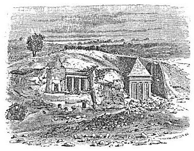 |
| TOMBS OF JAMES AND ZACHARIAH. |
Gethsemane, are some ancient tombs of more importance. Among these are the so-called Tomb of Absalom, of James the Less, of Jehoshaphat, and of Zachariah. The second and last appear in the cut on this page. In all probability these are all misnamed, for none of the [211] names can be traced back beyond the fourth century. Nearly in front of these tombs the Valley of Jehoshaphat is crossed by another low bridge, and a steep path leads thence up the hill to the southeast angle of the har'am wall. At the corner of this bridge is the mouth of a well, or cistern, out of which much water is drawn and carried away in skins.
South of the Mount of Olives, and beyond the depression across which the road to Jericho passes, rises a hill somewhat lower than the Mount of Olives, called the Hill of Offense. It is so called from the belief that its summit was the site of the idolatrous worship established by Solomon "on the hill that is before Jerusalem."100 On the western slope of the Hill of Offense is a small village of miserable huts, called Silwân' (Siloam). Its huts are built in a row along the side of a narrow pathway on the hillside, and they consist partly of old sepulchres with walls built up in front of them. It is inhabited by Ar'abs, who cultivate small fields in the vicinity.
Our circuit of the city will be completed by considering so much of Mount Zion as lies south of the southern wall, and the valley and hill south of it. About one-half of the summit of Mount Zion, the southern half, as we have stated before, now lies outside the city, and is cultivated in grain.101
Starting due south from Zion gate,102 you pass on your right the Armenian Monastery of Mount Zion, which, they say, is the house of Caiaphas, and within which the traveler is amused at being shown the stone which closed the sepulchre of Jesus, the prison in which Jesus was confined during his trial (?), the spot where Peter's denial occurred, and the place where the cock crew. Passing on and descending a little, you come to a separate building due south of the convent, called by the Moslem the Tomb of David, and by Christians the Cænaculum, or Place of the Last Supper. In this you listlessly look around while you are pointed to the room, and this not an "upper room,"103 where Jesus and the twelve ate the last supper. Eastward of this room, and on a little higher level, reached by a flight of steps, is a large room, through the latticed door of which you are allowed to look and behold a cenotaph called the Tomb of David. It is about 12 feet long and 5 high, coffin-shaped on top, and covered with a dusty, faded cloth of cotton or wool, with broad horizontal stripes of green, yellow, and red. The room is bare, and its walls are whitewashed. It is claimed that this is a mere copy of the real tomb, and that the [212] latter lies in a cavern beneath the floor. Dr. Barclay's daughter, by disguising herself in Turkish costume, and securing the attendance of a female member of the family of the custodian, gained admittance to the real tomb, and made a draft of it, which is represented in her father's book by a richly colored engraving. She is the only Christian in modern times who has enjoyed this privilege. But whether the tomb is the real tomb of David or that of some unknown Mohammedan celebrity, cannot be determined until the superstition of its present custodians shall give place to free and enlightened investigation. The entire building, according to Warren, belongs to the crusading period.
The southern side of Mount Zion descends by a very steep slope into the Valley of Hinnom, which has been described already on page 164. Along the southern side of this valley rises an almost perpendicular precipice of rock to a height nearly equal to that of Mount Zion, while a hill sloping back from this reaches a height greater than that of Zion. Near the mouth of the Valley of Hinnom, where this precipice makes an angle with the western side of the Valley of the Kedron, a steep path, partly cut in the rock, and consisting partly of a flight of steps, leads to the summit. Here you are in the midst of what is now called Acel'dama, the field of blood; but it appears like anything else than a "potter's field,"104 seeing that it is all naked rock. The whole face of the rock is honey-combed with ancient Jewish sepulchres, and the large chamber of one of them is fitted up as a chapel in which to celebrate mass. It is doubtless on account of the multitude of these burial-places that the spot has been fixed upon by the monks as the field in which strangers were buried; but a charity graveyard was never, in any age of the world, filled with costly rock-hewn sepulchres like these. The intelligent traveler knows by a glance that this cannot be the Acel'dama of Scripture, but he knows also that it must be a set of tombs of the really ancient Jewish period, seeing that none such have ever been dug or even used by subsequent inhabitants of the country. This entire hill south of the Valley of Hinnom has been called the Hill of Evil Counsel, from the tradition, equally unfounded with that concerning Acel'dama, that on it, in a country residence of Caiaphas, was held the council of the chief priests in which they resolved to take Jesus by subtlety and put him to death.105 [213]
[LOB 143-213]
|
[Table of Contents] [Previous] [Next] |
J. W. McGarvey Lands of the Bible (1881) |
|
Send Addenda, Corrigenda, and Sententiae to
the editor |