 |
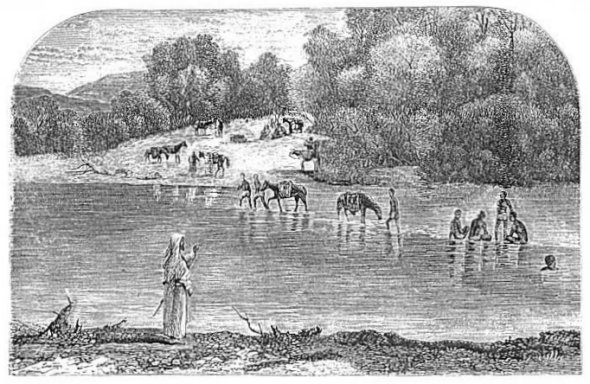
| THE JORDAN,--A FORD AT THE HEAD OF A SHOAL. |
| Page 346. |
|
[Table of Contents] [Previous] [Next] |
J. W. McGarvey Lands of the Bible (1881) |
C H A P T E R V I I I.
PLACES ALONG THE JORDAN AND BEYOND.
§ I.
IN THE PLAIN OF JERICHO AND THE PLAIN OF MOAB.
HAVING given a general description of the Jordan Valley in Part First, Chapter I., § 7, we now discuss its topography; and we begin with the broad plain lying at the head of the Dead Sea. This plain, as before stated, is about 14 miles wide from east to west, with the Jordan flowing through the middle of it, and it extends up the river, before the valley contracts into a narrow plain, about 10 miles. That part of it lying west of the river is called the Plain of Jericho, and that east of the river the Plain of Moab.
In Chapter II., § 4, of this part, we have followed the road from Jerusalem to Jericho as far as its entrance into the plain, and we stated that, just before it descends from the mountains into the plain, it skirts the deep gorge of Wâd'y Kelt (the Brook Kerith). When it enters the valley the bed of that wâd'y lies but a short distance to the left, and it runs with an acute angle to the road until, about a mile from the hills, the road crosses the wâd'y. About a quarter of a mile to the right of this crossing-place is the first object of special interest that catches the eye,--the remains of a large ancient reservoir. It is 188 yards long by 157 wide, and it is called by the natives Birket Musa (the Pool of Moses). Its eastern wall is still almost perfect, and stands about eight feet above the accumulated earth inside; but the other walls are much broken, and the pool is nearly filled up. It once held an immense quantity of water, which could be used for irrigating the surrounding lands.
After crossing the Kelt the road leads almost due east, to the miserable village Erîha, whose name is an Arabic corruption of the name Jericho. It is a small collection of huts of the meanest kind, built partly of sun-dried bricks and partly of small rough stones, and inhabited by Ghuwar'ineh Ar'abs. It has one house of a better class in which travelers who are without tents can obtain uncomfortable lodging. The Greeks have recently erected here a small convent. It is well built of limestone, is about 80 by 40 feet in extent, one story high, and is [339] occupied by four or five monks. At the eastern edge of the village stands the ruin of an old stone tower, about 15 or 20 feet high, which some one has attempted to dignify by calling it the house of Zacche'us.
West of the village the Kelt is crossed by two aqueducts on arches of stone. One of them, supported by 11 arches, still conveys an irrigating stream to the fields south of the Kelt, but the other is in ruins. Another irrigating stream, drawn from the Kelt higher tip, runs parallel with its parent stream near the southern bank of the latter. These are the feeble remains of a system of irrigation which once made the plain south of the Kelt a paradise.
A little more than a mile east of Erî'ha are the ruins of an ancient city which has been identified as Gilgal. The identification is established by the locality, which agrees with the account given in Joshua,1 and by the preservation of the name in the Ar'abic Jiljû'lieh. The ruins are meagre,--so much so that one might pass near them without observing them,--but they are the evident remains of a very ancient city.
The village of Erî'ha, though it perpetuates the name of Jericho, is not on the site of the original city. The latter is at the foot of the hills, two miles to the northwest, and one mile and a half north of the Jerusalem road where it enters the plain. It is reached from the latter road by crossing the Kelt near the hills and riding nearly due north along the western edge of the plain. It is identified by the copious fountain called by the Ar'abs Ain es Sûl'tan, and by Europeans, Elisha's Fountain. This can be no other than the fountain healed by Elisha,2 for it is the only fountain in this plain; and the second Jericho, built by Hiel in the reign of Ahab on the site of the original city, stood near this fountain.3 It is probable that the disaster which befell Hiel in compliance with Joshua's curse prevented the city from being peopled, and hence it became the abode of the poor prophets, for whose benefit Joshua healed the waters. The Jericho in which Herod the Great had a palace, and which was visited by Jesus, occupied a still different site,--at the foot of the mountains between the fountain and Wâd'y Kelt.4
All travelers pitch their tents on a little plateau just north of Elisha's Fountain. The camping-ground is sufficiently elevated to afford a good view of the plain, with the Dead Sea in sight toward the south, [340] and the mountains of Moab bounding the horizon on the east. Among these mountains Mount Nebo is distinctly visible toward the southeast, and it appears to the unpracticed eye only five or six miles distant.
Several square miles of the plain, extending from Elisha's Fountain to the east and the south, are irrigated by the waters of the fountain, which are led over it by a network of artificial channels, and this area is clothed in verdure while all around is parched and dry. Once these waters were conveyed much farther, for out on the verdureless plain are still seen long lines of low stone walls, built to support plastered channels for irrigating streams. A short distance to the southwest of the fountain are the ruins of some ancient mills, called the Sugar-Mills from the fact that sugar was once manufactured here from cane which grew in the plain. These mills were propelled by water conveyed on stone aqueducts from springs higher up in the mountains, and the remains of these aqueducts are still seen. The water, after propelling the mills, was conveyed, like that from Elisha's Fountain, out into the plain, and used for irrigation. It was this abundance of water, as we have intimated above, which once made the Jericho Plain a garden of delight.
From the camping-place above Elisha's Fountain, the traveler who has come thither direct from Jerusalem usually makes his first visit to the shore of the Dead Sea. It is a ride of about eight miles, and it is usually taken very early in the morning to avoid the intense heat in the after-part of the day. After crossing Wâd'y Kelt below Erîha, the trackless route leads over a very desolate region, growing more and more so as the sea is approached. Here and there are low spots in which water settles in spring and keeps them moist after the higher surface is dry, and in these a coarse vegetation continues to grow when the chief part of the plain is bare. Swarms of yellow locusts, such as John the Baptist fed upon, are seen here, and flocks of storks which manifest but little fear for man, walk solemnly about and feed upon the locusts. The sand over which we ride in approaching the sea forms a smooth beach near the water's edge, and also extends into the water, making a smooth bottom with a gradual descent. All visitors, whether they can swim or not, may go in with impunity, and few deny themselves the pleasure of doing so.5
After bathing in the sea it is usual for the traveler to ride to the Pilgrims' Bathing-Place on the Jordan, about four miles from its mouth. [341] Usually this ride is over a dry plain and a firm path, but in the rainy season it is sometimes almost impracticable on account of the mud. So President Bartlett found it as late as the middle of March, in the year 1874. He says: "The region immediately before us was marshy, and the late rains had made a part of this plain as watery and muddy as a 'slough-hole' in a Western prairie. . . . The horses sank to their girths, and once or twice still deeper, until sheikh, dragoman, and three of our company were rolled successively from their seats, to pick their way by leaping from clump to clump as best they could."6
The Pilgrims' Bathing-Place is so called because thousands of pilgrims of the Greek Church, who visit Jerusalem every spring during "holy week," come down to this place on Monday after Easter to bathe in the Jordan. Lynch's party reached the spot in their descent of the Jordan on the night of Easter Sunday, and on the next morning at daybreak they witnessed the arrival of the pilgrims. Lynch describes the scene as follows: "In the wild haste of a disorderly rout, Copts and Russians, Poles, Armenians, Greeks, and Syrians, from all parts of Asia, from Europe, from Africa, and from far-distant America, on they come; men, women, and children of every age and hue, and in every variety of costume; talking, screaming, shouting, in almost every known language under the sun. Mounted as variously as those that had preceded them, many of the women and children were suspended in baskets or confined in cages [they were on camels], and, with their eyes strained toward the river, heedless of all intervening obstacles, they hurried eagerly forward, dismounted in haste, and, disrobing with precipitation, rushed down to the bank and threw themselves into the stream. Each one plunged himself, or was dipped by another, three times below the surface in honor of the Trinity, and then filled a bottle or some other utensil from the river. The bathing-dress of many of the pilgrims was a white gown with a black cross upon it. Most of then, as soon as they dressed, cut branches either of the agnus castus or the willow, and, dipping them in the consecrated stream, bore them away as memorials of their visit. In an hour they began to disappear, and in less than three hours the trodden surface of the lately crowded bank bore no human shadow."7 Thomson also witnessed this scene, having gone with the pilgrims from Jerusalem for the purpose. He states that many of them swam across the river, but that three who were not expert swimmers attempted it and were swept [342] away by the current and drowned. Such was the fanaticism of the crowd, however, that the disaster caused but little sensation among them.8
This spot was selected by the Greek Church as a bathing-place because it was believed that here Jesus was baptized. There is a high degree of probability that this belief is correct, for John certainly commenced baptizing in this part of the river, and it is almost certain that he selected as the exact place of baptizing a ford or ferry toward which routes of travel concentrated, and where the banks were suitably graded. But this is the first place of the kind above the mouth of the river, and the next is nearly four miles above. The water is here too deep for fording, except in the dry season, being usually about 10 feet deep in the spring, but there are two points, about 200 yards apart, at which there is a pebbly bottom and a gradual descent into the water to any desired depth. At the more southern of these two points the deep water lies next to the eastern bank, and only the western side is suitable for baptizing, but at the other there is shallow water on both sides. In both places the current is swift in the channel,--from four to five miles an hour,--but it is sufficiently slow in the shallower water for convenient baptizing. At neither place, however, could the ordinance be conveniently administered when the river is out of its banks, and consequently, at such times, John resorted to localities higher up the stream, or to such a place as Ænon.
While the water at this place during the dry season was all that John could wish, in other respects it was a place during the same season which no preacher who studied his own comfort, or that of his auditors, would select for such a ministry as John's. The Scriptures locate it in the "wilderness of Judea," referring to the desolate plain west of it, whose desolation extends over the mountains that bound it on the west. The immediate banks of the river are equally a wilderness, for the lower bottom-land is uninhabited, on account of the annual overflow, and it is covered with a jungle of low-growing trees and shrubs. It is so deeply depressed that scarcely a breath of wind can reach it in the hot season, and the air is thick with mosquitoes and flies. It would be difficult to find a more disagreeable place for the assembling of multitudes, and the circumstance throws a new light on the ministry of John. It shows that in the place which he was moved to select for the first part of his labors, as well as in his food and raiment, he practiced the self-denial which he inculcated. It also [343] illustrates his marvelous power over the people whom he succeeded in drawing to such a place and retaining as hearers until he brought them to repentance.
A short distance above the bathing-place, Wâd'y Kelt empties into the Jordan, having wound its way across the plain in a southeasterly direction. In its bed, about midway the plain, Conder finds the "Valley of Achor," in which Achan, at the command of Joshua,9 was stoned to death by the children of Israel. It is identified by the fact that here the wâdy-bed is wide and shallow, and is filled with water-worn stones of a suitable size for the stoning, and there is no other valley near Joshua's camp at Gilgal of which the same is true.10
We now return to the camp-ground above Elisha's Fountain, with the purpose of completing our description of the Plain of Jericho. Immediately west of the camp-ground there rises an isolated ridge 50 feet high and extending about a quarter of a mile from north to south, which is proved by excavations made in it by Captain Warren's party to be a mass of broken stones, cement, sun-dried bricks, and fragments of pottery. This is what is left of the original Jericho. Mounds of similar material stand at intervals along the plain to the southward as far as Wâd'y Kelt.
West of the ridge just mentioned rises another of natural rock about 150 feet high, and west of this an elevated valley about half a mile wide, separating the ridge from a mountain beyond. This valley is rich, green, and well cultivated, and the mountain beyond it is the one selected by the Crusaders, in the year 1112,11 as the mount of the Saviour's temptation. They called it Quarantan'ia, from the 40 days of the Saviour's fast, and the Ar'abs attempt to call it by the same name, but pronounce it Kûrûntûl'. Its front is almost conical; its sides are honeycombed with the cells of monks and hermits, and its summit is crowned with the ruins of a castle built by the Crusaders. It is a mountain of crumbling limestone, brown from the exposure of thousands of years, and projecting like a promontory from the higher mountains behind it. The selection of this as the Mount of Temptation, as Conder remarks, is a striking illustration of the "simplicity of men's minds in the Middle Ages," for, while the Scripture represents Jesus as being placed on an "exceeding high mountain,"12 this mountain's top is actually lower than the surface of the Mediterranean [344] Sea, and it is surrounded on every side by mountains, not many miles away, more than double its height. As Jesus was to be shown "all the kingdoms of the world and the glory of them," a point of much higher relative elevation must have been selected, and there is no special reason for supposing that it was in the vicinity of Jericho.
The road from Jericho to Bethel and Ai leads to the northwest from Elisha's Fountain, and passes up a wâdy north of Mount Quarantan'ia. At a distance of about three miles it passes a group of three springs on the left, so close together that they have the single name Ain ed Dûk. They are situated on the northern slope of a hill. The highest and largest bursts out from under the roots of a large dom-tree, and runs away in a stream six feet wide and six inches deep. It is led along an artificial channel cut on the hillsides around Mount Quarantan'ia, and its waters once propelled the mills above mentioned (page 341), near Jericho. Now they run waste over the little valley in front of that mountain, making it green and beautiful, and they are also used to irrigate the slopes below the channel on their way thither. The next lower spring, also shaded by a dom-tree, is not quite so copious. It is first led along the brow of the wâdy beneath it for a hundred yards or more, and then crosses this wâdy in a plastered channel four feet wide and two feet deep, which is supported by a series of arches built up from the bottom of the wâdy. In the bottom of the wâdy is one large arch, with 26 feet span and piers 12 feet square, above which rise six smaller arches, reaching out to the sides of the wâdy, and above these six more, making three series of arches rising one above another, with an aggregate height of about 50 feet. The work is evidently ancient, though it shows signs of recent repairs. The water, after crossing, is led away in an irrigating channel to the fields farther eastward, where it is all absorbed by the thirsty soil. The third and smallest spring, after irrigating a luxuriant cucumber-garden, falls into the wâdy, runs along its rocky bed, and passes under the arches above described. This is the most copious flow of water from one spot to be seen anywhere about the lower portion of the Jordan Valley. It combined with Elisha's Fountain to make the region about Jericho the paradise which it once was.
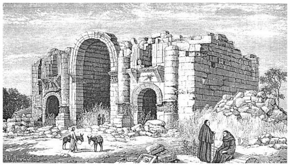
Having now described the broad Plain of Jericho, which is about 7 miles wide from the mountains to the river, and about 10 in length from the Dead Sea to the headland which runs out from the mountains at its northern extremity and marks it as a separate district, we next go across the river to the plain of almost exactly the same dimensions on the eastern side. We cross by a ford almost due east from Elisha's [345] Fountain called Ghâranîzeh, and sometimes the Jericho ford. It is about four miles in an air-line north of the bathing-place. A ferry-boat is kept in readiness, and must be used during a large part of the year, but just below the ferry-crossing the water breaks over a shoal, and at the head of this it can be forded when it is very deep above. The author's party forded here on the 5th of May, 1879, the water coming about half-way up our saddle-skirts. On the eastern bank at this point is an admirable place for baptizing, and a more airy and comfortable place for the assemblage of a large multitude of people than at the bathing-place below. This is the ford which is exhibited in our cut on the opposite page. It is the crossing-place for travel between Jerusalem and Es Salt.
The plain upon which we have now entered has a much finer soil and is much more abundantly watered than the Plain of Jericho. It is the plain on which Israel camped before the death of Moses, and whence they marched across the Jordan under the leadership of Joshua. It is traversed by four streams of water, whose sources are perennial springs in the mountains, though their waters are absorbed in the driest part of the summer ere they reach the river. These are the Suwei'meh on the south, next north of it the Hasbân', then the Kefrein', and last the Nimrîn'. The Kefrein' has the shallowest bed, and it is consequently used most for irrigating purposes by the few Ghuwar'ineh who cultivate small patches in the plain. Near the foot of the mountain-range on the eastern side of the plain there are six tells (mounds), the evident remains of ancient towns. Beginning at the south, within two or three miles of the Dead Sea, and going north, they are found in the following order: Suwei'meh, Ek'tanu, Er Râ'ma, Hammâm', Kefrein', and Nimrîn'. At the foot of Tell Hammâm there is a hot spring which gives name to the tell. The temperature of its water is 102°. Three of these are identified with places named in the Bible, viz., Tell Nimrîm' with Beth-Nim'rah,13 Tell Kefrein with Abel-Shittim,14 and Suwemeh with Beth-Jeshimoth.15 The camp of Israel extended from the last to Abel-Shittim, a distance of not less than six miles,16 and the tents were pitched, no doubt, over the entire space, but especially along the banks of the streams. If we were entirely certain of these identifications, we could form a close estimate of the space covered by the camp. On the supposition that they are correct, the camp may be estimated as at least six miles square, or as covering--whether in a square or not-- [346]
|
| THE JORDAN,--A FORD AT THE HEAD OF A SHOAL. |
| Page 346. |
36 square miles. When the vast multitude broke up their camp and marched to the bank of the overflowing Jordan, their front was probably eight miles long, and the river was cut off from their extreme right down to the Dead Sea.17 The city of Adam, the point to which the intercepted waters were heaped up by the onflow of the stream from above, has not been certainly identified, but it is probably Dam'ieh, about 24 miles above the mouth of the river. Even after the waters were thus cut off it was no easy task for the host to move across. The shortness of time did not admit of their forming into narrow columns and crossing at fords or other places of easy approach, which would have required several days, but they were compelled to move forward in a mass, descend the bluff, push their way through the brushwood of the muddy bottom-land, climb down into the wet bed of the river, and clamber over similar obstacles on the other side as best they could. It must have required a long and toilsome day's march for all the people to pass "clean over Jordan." Was this exhausting toil a type of the hard struggle by which the Christian wades into the bed of the dark river, even after its waters have been cleft asunder by his Joshua?
One of the most interesting questions connected with the topography of the lower Jordan plain is that concerning the sites of Sodom and Gomorrah, and the other three cities confederated with them. The chief point at issue is whether they were near the upper end or the lower end of the Dead Sea. If at the upper end, they probably stood on the Plain of Jericho, south of Wâd'y Kelt; if at the lower end, the plain in which they stood must be now occupied by the lagoon.18 Explorers are divided over the question, the earlier class favoring the southern locality, and the more recent class the northern.
All of the local traditions preserved among the natives of the country are in favor of the southern locality. The ridge of rock-salt extending along the southwestern shore of the sea19 is called Jebel Us'dûm (Mount Sodom), from the belief that Sodom stood near it. The sea itself is called Bahr Lût (Sea of Lot), from the belief that it is connected with Lot's history; and the two traditions taken in connection evidently point to the southern end of the sea as the site of Sodom. Furthermore, the name of Zoar, the city to which Lot fled when he left Sodom, is still attached to the ruins of an ancient town near the neck of the peninsula, in the Ar'abic form of Zoghal.
As we have said in our description of the Dead Sea,20 the [347] supposition of the southern locality requires the additional supposition that the present lagoon was then a plain, and that its surface was sunk either by the convulsions attending the destruction of the cities, or by fire consuming the "slime-pits,"21 which abounded in the plain, so that the water of the sea flowed in upon it and covered it a few feet deep, as at present. This supposition finds some support in the Scriptures. That some serious change in the condition of the surface itself occurred seems to be affirmed in the statements that God "overthrew those cities, and all the plain," and that Abraham, when he viewed the scene the next morning, "looked toward Sodom and Gomorrah, and toward all the land of the plain; and behold, and lo, the smoke of the country went up as the smoke of a furnace."22
On the other hand, against the southern locality and in favor of the northern, are urged the following considerations:
1. Chedorla'omer, having subdued certain tribes south of the Dead Sea, next smote "the Amorites, who dwelt in Haze'zon-Ta'mar," before he approached Sodom.23 But Haze'zon-Ta'mar is En'gedi,24 which lies half-way up the western shore of the sea, and the supposition of a southern site for Sodom would require the army to have passed Sodom and gone twenty miles up the coast to attack En'gedi, and then to have returned to attack Sodom. This is by no means probable.
2. When Abraham and Lot were about to separate at Bethel, it is said that Lot "lifted up his eyes and beheld all the plain of the Jordan; that it was well watered everywhere before the Lord destroyed Sodom and Gomorrah."25 It is urged that Lot could not have seen this plain if it had been at the southern end of the Dead Sea. But this objection has less force than has been ascribed to it, for Lot could not literally have seen "all the plain of the Jordan," as this expression is now understood, unless he had gone about ten miles east of Bethel and stood upon some of the mountains overlooking it. Still, it is true that by doing this he could have seen all the plain, and to have seen all the plain south of the Dead Sea he would have been compelled to travel more than double the distance. It may be, after all, that the historian, in using this language about Lot, refers to his mental survey of a plain which he must have seen very often before, rather than to a literal survey of it with his eyes.
3. After Lot had made his survey, it is said that he "chose him all [348] the plain of the Jordan," and that he "dwelled in the cities of the plain, and pitched his tent toward Sodom."26 It is affirmed that these "cities of the plain" are the same "cities of the plain" which were destroyed with Sodom, and that the plain is by clear implication "the plain of the Jordan." But the plain south of the Dead Sea, 45 miles below the mouth of the Jordan, could not, with any propriety of speech, be called the "plain of the Jordan."
4. In the view which Moses enjoyed from the top of Pisgah, it is said that he saw "the plain of the valley of Jericho, the city of palm-trees, unto Zoar."27 This language implies some connection, not very remote, between Zoar and the Plain of Jericho, and the language could scarcely be used if the two were separated by the entire length of the Dead Sea. But Zoar was one of the five cities of the plain, spared from the fate of the others for Lot's sake,28 and its locality determines, proximately, the locality of the others. Professor Merrill, of the Palestine Exploration Society, claims to have found Zoar, both in name and location, in Tell Ektanu, one of the six mounds mentioned in a former part of this section,29 on the eastern border of the Plain of Moab. An account of the discovery, together with an elaborate argument in favor of locating the destroyed cities in the Plain of Moab, is given in the Fourth Annual Statement of the Palestine Exploration Society, 1877.
A candid consideration of the evidences above adduced seems to require us to abandon the old theory as to the location of these cities, and to suppose that the local traditions, which furnish almost its only support, originated from an unsuccessful attempt at an early period since the Christian era to settle the question which still remains unsettled among scholars and explorers. Of one fact the investigations thus far instituted clearly convince us,--that the besom of God's destruction swept clean when it swept these cities away, leaving not a vestige behind. This is certainly the case if they were at the southern end of the sea; and Conder's explorations make it equally certain if they were on the Plain of Jericho. He says: "Over almost every acre of ground between Jericho and the Dead Sea I rode day by day. The whole is a white desert, except near the hills, where rich herbage grows after the rains. The time of year was most favorable for such explorations, because no long grass existed to hide any ruins. In all that plain I found no ruin, except the old monastery of St. John and a little [349] hermit's cave; and it seems to me that no other ruin will ever there be found."30 Professor Merrill has directed attention in an entirely new direction,--to the plain at the head of the Dead Sea on the eastern side of the Jordan; and if he is correct in locating Zoar, the other cities must certainly have been in the same plain, seeing that Lot could not have crossed the river and traversed the width of the plain besides, between daylight and sunrise, the time of his flight from Sodom to Zoar.31 But this plain has also been examined almost as carefully as the one on the opposite side of the river without satisfactory results. Excavations may possibly yet bring something to light which surface examinations have failed to reveal, but this is the only source of hope now left for the discovery of a single stone that once lay in the walls of Sodom.
§ II.
IN THE UPPER SECTIONS OF THE JORDAN VALLEY.
The western side of the Jordan Valley, all the way from the Plain of Jericho to the Lake of Galilee, is singularly destitute of places of interest. The most striking feature in its landscape is Kûrn Sût'tûbeh, about 24 miles from the Dead Sea. It is a sharp conical peak resting on the eastern extremity of a rugged ridge, which here juts out from the mountains almost entirely across the valley. It rises to the height of 2000 feet above the plain, and it is visible from almost every part of the Jordan Valley, both above and below. On its summit are some singular ruins, of whose history nothing is known. In riding to it from Jericho we cross four streams of water, but we pass no human habitations, and we see but little tillage.
Immediately east of Kûrn Sût'tûbeh, and about two miles distant, is the Dam'ieh ford (more properly ferry) across the Jordan, and Wâd'y Far'rah, the stream on whose banks Ænon was situated, flows between the mountain and the river on its way to enter the latter a few miles below. The descent from the upper into the lower valley, as we approach this ferry, is very steep. The cliff is of whitish clay, and is 100 feet high. The lower valley, for a short distance up and down the stream, is nearly two miles wide and full of verdure. It presents a pleasing contrast in summer with the barrenness of the upper valley. The river lies nearer the eastern than the western side. The author found at the ferry a rude but strong ferry-boat, drawn across by two [350] strong ropes fastened to trees on either bank. As the author's party crossed they made the measurements which are given on page 34 by stretching a tape-line along one of the ropes. This was on the 23d of April. Our party also bathed in the river, as we had done at the two ferries below, so as to test by actual experiment the character of its bottom and the strength of its current.
Due east of the ferry, and about 300 yards distant, is an elevated platform of earth and stone, 145 yards wide, 200 long, and 50 feet high, called Tell Dam'ieh. On its top, and near the eastern end, are the ruins of a building. This is evidently an artificial mound, and it is supposed to be the site of the city of Adam, to which the waters of the Jordan were heaped up when it was cut off for the passage of the children of Israel."32
About a quarter of a mile above the ferry are the remains of an ancient bridge. The span which crossed the river has entirely disappeared, but on the low ground east of the river two large arches are still standing entire, and also the piers of three others. The span of the arches is 20 feet, and the bridge was 12 feet wide. It may be that the river once flowed under these arches and has cut for itself a new channel farther west, but it is more probable that they were constructed merely for the span of the bridge across the low ground on that side. The western bank of the river is above high water. So dense a growth of cane and brushwood now covers the ground between the ferry and the bridge that the author's party had to secure the service of two men with axes to chop a way through the most tangled parts of the thicket before they could ride to the bridge.
The valley of the river Jabbok (Wâd'y Zerka) opens into the Jordan Valley from the east, immediately opposite the Dam'ieh ferry, but the stream itself, contrary to the representations on the old maps, turns to the northwest as it approaches the Jordan, and enters the latter above the bridge just described.
The eastern side of the Jordan Valley, from the Jabbok south to the vicinity of Wâd'y Nimrîm', nearly opposite Jericho, is a waterless plain, and is the only part of the valley east of the river that is so. Dr. Merrill, who explored it carefully in 1876, marks it on his map "Waterless Region," while of that portion from the Jabbok north to the Lake of Galilee he says: "The Manadî'ra (the Yar'mûk) on the north is a river as large as the Jordan at its exit from the lake. It is full of fish, and before it joins the Jordan it is crossed by a substantial bridge. The [351] Jabbok on the south is also a river, but much smaller than the Manadîra. Between these two no less than eleven living streams, more than half of which can be called large ones, flow down the hills to water the plain. Canals carry the water from these streams in all directions, and irrigate the vast wheat-fields already mentioned, which are the pride of the valley."33 The same writer says that, while there are no ruins in this valley, there is a ruin in every instance at the point where these streams leave the foot-hills. Thirteen of these are marked on his map, and seven of them appear to have been places of wealth and importance.34
Immediately north of the Jabbok is the broad expanse of the Jordan Valley called the Plain of Succoth. It is 7 or 8 miles wide and 9 or 10 long, and it is the most beautiful portion of the entire Jordan Valley, not excepting the Plain of Shittim. Its surface is almost a dead level, broken here and there by artificial mounds, the sites of ancient towns, and it is intersected in every direction with little canals for irrigation. The writer, in riding across the plain away from the road, crossed many of these canals, some of them with water flowing in them at the time. Those in the more southern part of the plain are supplied by the Jabbok, which is tapped for the purpose where it leaves the bluffs, and loses so much of its water that it is much smaller below than above. The entire plain is covered with verdure, and if cultivated with any skill and taste it would be an agricultural paradise. Three of the mounds just mentioned have ruins on them, and the others are thickly strewn with broken pottery, sure sign of past habitations. One of these, called Tell Hammâm(Mound of the Warm Spring), on account of a warm spring near it, is near the northern bank of the Jabbok, and close to the bluffs. The author had some difficulty in finding the warm spring itself, but was finally led to it by an Ar'ab who left his harvest for the purpose. It is a feeble spring, a quarter of a mile east of the tell, and its temperature is 96°. It is immediately on the bank of the Jabbok, and sends three very feeble streams into the river. The author's party, after spending some hours exploring the southern portion of this plain, rested and lunched under the shadow of an immense rock near the bluff, which had fallen from the cliff above. The site was sufficiently elevated to afford a view of the entire plain, with the mountains of Samaria bounding the horizon to the west, and the top of Mount Tabor visible in the northwest. The plain before us brought vividly to view the [352] immense flocks and herds of Jacob which once grazed here after coming from Padan-aram, and the booths which he built to protect them from the hot sun of their first summer in this more southern climate. When he had spent the summer here, he crossed, the river at the Dam'ieh crossing when it was low in the fall, and, leaving Kûrn Sût'tûbeh, which rises beyond the river almost like a church steeple, to his left, he moved slowly up Wâd'y Far'rah, northwestward, past Ænon to Shechem, where he bought a piece of land and made a temporary home.35
The glance which we have now given at the eastern Jordan Valley enables us to trace the route of the Jews of Galilee in their journeys to Jerusalem and back. In order to avoid passing through the territory of the unfriendly Samaritans they came down east of the Jordan, and Jesus sometimes followed the same route.36 They crossed the Jordan on a bridge just below its outlet from the lake, came down the eastern plain past richly cultivated fields and many villages and towns, crossed again at the Dam'ieh ferry to avoid the waterless stretch of 12 miles below on the eastern side, thence came down the western plain to Jericho, entered it by its northern gate, passed out by the southern, and thence passed up into the hills on the present road from Jericho to Jerusalem.
The next point of interest in the Jordan Valley, going northward, is the ford called Abâr'ah, which Conder identifies with the Bethab'ara of John i. 28. It is just above the mouth of the river Jalûd', which originates in the Valley of Jez'reel, runs through Beisan', and thence crosses the western Jordan Valley in a southeasterly direction. Abâr'ah means a place of passage, and Bethab'ara means house of the passage. In defending the identification Conder says: "It may be said that the name Abâr'ah is merely descriptive, and perhaps applies to several fords. That it is descriptive may be granted: so is the name Bethab'ara, or Bethel, or Gibeah, or Ramah. That it is a common name may be safely denied. We have collected the names of over 40 fords, and no other is called Abâr'ah; nor does the word occur again in all the 9000 names collected by the survey party."37 The same writer corrects the commonly-received mistake that Jesus was baptized at Bethab'ara, and shows that it is mentioned only in connection with events which occurred on consecutive days after the temptation.38 More than forty days had elapsed since the baptism of Jesus, and in this [353] interval John had passed from the lower Jordan 50 miles higher up the river.
A very important consequence results from this identification, and helps to confirm it. When Bethab'ara was supposed to be at the bathing-place below Jericho, it was almost impossible to account for the presence of Jesus and his disciples at the wedding in Cana on the second day after leaving Bethab'ara,39 the distance being 75 miles by the nearest route of travel. But of the real Bethab'ara Conder says: "The ford Abâr'ah is about 22 miles in a line from Kefr Kenna, and no place can be found on the Jordan much nearer or more accessible to the neighborhood of Cana."40 The mother of Jesus had only two and a half miles to come from Nazareth.41
About seven miles south of the Lake of Galilee is the only bridge across Jordan which is now in use. It is called Jier Mejamî'a (Mejamî'a bridge), and is the crossing-place for caravans from Beisan', Nab'lus, and all the region south of those places, to Damascus. After crossing here, the road follows the Jordan Valley for a few miles, and then turns up into the hills. This bridge is built entirely of blocks of basalt, and consists of one long arch spanning the river and three smaller ones on the eastern side, to allow the passage of the overflow when the river is out of its ordinary banks. The floor of the bridge is not level, as if intended for vehicles, but it climbs the arch, and has steps going up one side and down the other, each step about eight inches high.
It was evidently not built for vehicles, though strong ones could be drawn over it with proper care. A short distance from it on the western bank is a dilapidated khân, which once answered the double purpose of a halting-place for caravans and a military post for the protection of travelers. Just below the bridge there is an almost perpendicular descent of the river, with a fall of 10 or 12 feet. The current is fearfully rapid, and is lashed into foam by projecting rocks. Above, there is deep, still water and a broad channel.
A mile and a half above this bridge is the mouth of the River Yar'mûk (page 34), across which, a few miles above its mouth, but after it has entered the Jordan Plain, is a bridge for the passage of the Damascus road, mentioned above. On the northern bank of this river, three miles above its entrance into the Jordan Valley, are the [354] celebrated hot springs called by the natives El Ham'mâ. They are in a valley three-quarters of a mile wide, and are four in number. The largest occupies a basin 180 feet long by 90 in width, in which the water stands 6 feet deep, with a temperature of 103°. The overflow from it makes a pond, in a low place, 100 yards long, 10 or 15 wide, and 10 feet deep. The combined streams flowing from all these springs are estimated by Dr. Merrill as equal to a stream 21 feet wide and 20 inches deep, with a swift current. The waters are impregnated with sulphur and other minerals, and have healthy properties. Imposing ruins are scattered about them,--the remains of bath-houses and dwellings,--all of basalt. "If El Ham'mâ could be rebuilt," says Dr. Merrill, "it would be one of the most attractive resorts in Syria, and perhaps in the world."42
The Jordan Valley above the mouth of the Yar'mûk to the southern end of the lake has a rich, reddish soil, is well cultivated, and very productive. That on the western side of the river, from the Mejamî'a Bridge upward, is narrow and broken, but it has many small fields of rich soil, and several villages perched on the tops of hills. The ruins of five bridges are seen in this section of the river, although the river is fordable at many places the greater part of the year.
We have now completed our view of the topography of the Jordan Valley, and the reader can readily see that the eastern half of it, though almost entirely unknown until within the last ten years, is by far the more interesting, both for its natural resources and its remains of antiquity.
§ III.
IN THE UPLANDS BEYOND THE JORDAN.
The number of localities beyond the Jordan which are mentioned in the Scriptures is surprisingly small, and of the few which are mentioned the accounts given are very meagre. Yet the number of cities and towns of which well-preserved and imposing ruins are left is greater in proportion to the territory than in the better-known country west of the river. There is also this remarkable difference, that the sites of the ancient cities west of the Jordan are still inhabited, and their ruins have been utilized in the construction of the present habitations, while those beyond the river are nearly all totally deserted, and remain as they were left by their ancient inhabitants. As our [355] purpose in this work is to limit our attention almost exclusively to places which have a Bible history, we can only glance at many places which would otherwise demand careful description. We begin with the more northern portion, called the Haurân' by the Ar'abs, but known in the Old Testament period as Ba'shan.
We have stated in § II. that the Mejamî'a Bridge, seven miles south of the Lake of Galilee, is the crossing-place for the road from Southern Palestine to Damascus. It was doubtless at this bridge that
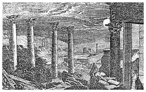
 |
| RUINS OF GAD'ARA. |
Naaman the Syrian crossed on his way from Damascus to Samaria to see the prophet and it was most likely in the river at this point that he dipped himself seven times in the Jordan in order to be healed of the leprosy.43 It was here, too, that Paul crossed on his way to Damascus as a persecutor,44 and it will be convenient for us to follow his route for a short distance in reaching the places to be described in this section.
Following the road from the bridge just mentioned up the Jordan [356] Valley to the Yar'mûk, crossing the river on the stone bridge which spans it, and then ascending the bank of the river to the hot springs, we reach the limit in this direction of the topography given in § II. About three miles farther up the Yar'mûk, and on its southern bank, are the ruins of Gad'ara, now called Mkês. It is situated on the western extremity of a mountain crest which stands between the Yar'mûk on the north and a deep wâdy on the south. Many heaps of hewn stones and fragments of broken columns whose capitals were of the Corinthian order are scattered about over a large space. The street pavement of basalt is preserved in many places, and is marked by the ruts of the chariot-wheels. Two theatres are found among the ruins, one of them in a good state of preservation. The principal street had a row of columns on either side, all of which are now broken. The cut on the opposite page gives a view of a part of this street, and of one of the theatres.
East of the city is the ancient cemetery, where there are many rock-cut tombs, and where as many as 200 stone sarcophagi have been counted. The city was built of basalt, which is the prevailing rock in all this region. The ruins are principally of the Roman period, very little that is Jewish being now discernible. Gad'ara was the chief city of the district called Decapolis,45 which lay to the southwest of the Lake of Galilee, and the land of the Gergesenes, on the eastern shore of that lake, was included in the territory belonging to the Gadarenes.46
About eight miles in an air-line due north of Gad'ara, and on the summit of the hills east of the Lake of Galilee, is the ancient city of A'phek, now called Fîk. It was here that Ahab, king of Israel, gained a signal victory over Benhadad, king of Syria, and where 27,000 of the men of the latter perished as the result of the falling of the city-wall.47 It is now a well-watered caravan-station on a more westward branch of the Damascus road, and is reached by following that road direct from the Mejamî'a bridge, but it has no important remains of antiquity.
The road by which we reach Gad'ara from the Jordan Valley continues up the valley of the river Yar'mûk in a course a little north of east until it intersects at Mzerîb the great pilgrim route from Damascus to Mecca. It requires nearly ten hours to make the journey over the [357] rough and crooked road, but in an air-line it is less than twenty miles between the two places. Mzerîb is one of the principal halting-places of the vast caravans of Mohammedan pilgrims who assemble every spring at Damascus and make the pilgrimage thence to Mecca, a journey of 27 days. The place is well watered by a large spring, and it is supplied with a very large castle for the protection of the caravans in times of lawlessness.
From Mzerîb to Damascus along the pilgrim road is about 45 miles. This route is not often followed by travelers, on account of the danger--real or imaginary--of being robbed on the way, but it is the route followed by Paul on his journey to Damascus, and the one on which an attempt has been made to fix the spot at which he was confronted by that vision from heaven which turned the tide of his life. But the account in the Scriptures is too indefinite to enable one to fix the spot with any near approach to accuracy.48
Instead of following the pilgrim road, or "Haj route," as it is usually called (from haj, a pilgrim), we take a southeasterly direction and visit Ed'rei, now called Derât' and also Ad'raha, about five miles distant. Ed'rei was the capital of Og, the king of Ba'shan, and it was here that Moses met him and "smote him until none was left him remaining."49 It possesses some interesting ruins above ground, besides extensive and labyrinthine dwellings under ground, chiseled in the rock, with an entrance on the side of a wâdy. It is the terminus of a stone aqueduct said to be 60 miles long, which crosses all the valleys in its course on arches, and conveys water to many places. At Ed'rei the remainder of its water empties into a large reservoir cut in the rock, 160 yards long, 65 yards wide, and 19 feet deep.
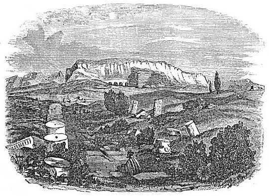
The next place of great interest in the direction which we are following is Bozrah, which lies about 30 miles a little south of east from Ed'rei. This is not the Bozrah frequently mentioned in the Bible, for that city was in the land of Edom,50 but the first appearance of its name in history was in A. D. 105, when it was made the capital of the province of Arabia under the Romans, and the seat of a Roman colony. It afterward became a Christian city, and was the seat of a bishopric. It was visited by Mohammed with the trading caravan to which he was attached before he became a prophet, and during the Mohammedan dominion it became a very famous city.51 Its decay dates from the year 1151, when it was almost destroyed by earthquakes. It is [358] now occupied by only 30 or 40 families, who live among the ruins of its eastern side. Its eastern and southern walls are still standing, in the main, and the foundations of the northern and eastern walls are traceable. Its principal street runs through in a straight course from the western gate to the eastern, and it is intersected by a similar street running north and south. The former passes under a Roman triumphal arch, with a central arch 41 feet high and two side arches of smaller dimensions. This street was originally lined with columns on either side, and it is flanked with impressive ruins. On the left, where
 |
| A VIEW OF BOZRAH. |
it is intersected by the other principal street, are four columns 47 feet high, with finely-executed Corinthian capitals, which belonged to some building now entirely gone. Opposite them, across the intersecting street, are the remains of a beautiful temple. These are seen in the foreground of the above cut, while in the distance to the left stand other columns in immense ruins, and in the centre a ruined mosque with a well-preserved minaret towering above it.
Here, as at almost all the cities of this region, is ample provision for the storage of water. There are two large reservoirs,--one east of the city, and one near the southeast corner. The latter is 530 feet long and 420 wide. It is supplied by an aqueduct from distant mountain-springs, and has a stairway descending into it at one corner. South [359] of the city is an immense castle, supplied with underground rooms, extensive stables cut in the rock, a theatre with stone seats, and room for the accommodation of a large garrison. Complete desolation now broods over this vast city, once the abode of wealth, intelligence, and power. In the striking language of Dr. De Hass, "Here are Christian churches, some of them probably planted by Paul when he first preached in Arabia,52 once crowded with worshipers, but now empty and quiet as the grave; grand temples dedicated to different pagan divinities entirely deserted, without priest or devotee; triumphal arches erected in honor of men not known in history, tottering with age and ready to fall; beautiful tombs reared to the memory of persons long since forgotten; palaces, theatres, and other public edifices, unoccupied for centuries, and yet in their decay beautiful to behold."53
Among the sixty walled cities taken by Moses from Og, king of Ba'shan, only three are mentioned by name, and one of these is Salcah.54 As you stand on the castle or on the minaret at Bozrah and look due east, you see Salcah, about 12 miles distant, crowning a conical eminence 500 feet high. Between the two there is a Roman road as straight as an arrow over the level plain, with some of its pavement in a good state of preservation. The name of this very ancient city is preserved with only the slight change to Salchâd'. The approach to the walls on the summit of the hill is guarded by two deep moats, one higher up than the other, and in the days of its glory the city must have been well-nigh impregnable. The ruins are massive, and from their highest walls a magnificent view of the surrounding country is obtained. Eastward is the boundless desert, reaching off to the Euphra'tes; toward the southwest are the high mountains which overhang the lower Jordan; to the northwest is Mount Hermon; to the north are the lofts and rugged mountains of the Haurân'; while all around at short distances are a multitude of ruined cities which speak mournfully of departed glory. Armies and earthquakes, guided by an avenging Providence, have wrought this ruin.
If we leave Bozrah by the road leading to the north, we pass some town or city with interesting ruins every four or five miles, and at a distance of about 20 miles we reach Kûnawât', a ruined city on the [360]
 |
| A PALACE IN KÛAWÂT'. |
| Page 361. |
western slope of the Haurân' mountains. It is built on both sides of a stream which descends from the mountain, and it extends along the stream about a mile and a half. It is supposed to be the Ke'nath mentioned in Numbers (xxxii. 42) as having been occupied by a portion of the tribe of Manasseh, and, although that tribe could scarcely have extended their settlements so far north, the name tends to confirm the identification. Kûnawât' is equally remarkable with Bozrah for the extent and magnificence of its ruins, and what we have said of the former might almost be repeated of the latter. The cut on the opposite page presents a view of only one among its many ruined edifices, and only one of several views of the same building that are equally imposing.
In this city are found many well-preserved houses built entirely of stone, even to the door-shutters. The walls were built without cement, the stones in some instances being "dove-tailed," and in some instances cut with projections on top to fit into corresponding depressions in the bottom of those next above, so as to prevent them from slipping. The floors are made of slabs or of the natural rock artificially leveled, and the ceilings and roofs of thick slabs of stone long enough to reach from wall to wall, with their joints closed by cement. The door is a smoothly-dressed slab of sufficient width and height, and its hinges are projecting points at the top and bottom on one side, which fit in sockets made for them in the sill and lintel. They vary in thickness from 8 to 12 inches, and sometimes there are two slabs to an entrance, making a folding-door. It was no easy task to open such doors; but we are not to think of the children running in and out and slamming the doors behind them every minute in the day. They probably stood open day and night, except when danger from burglars required them to be closed, and in that case it is clear that burglars' tools were not of much service. Such doors are found in all the rocky regions of the Haurân' and the Lejâh'.
We have now mentioned all the localities in the region anciently called Ba'shan that our space and the plan of our work will allow. For further information on this most interesting region the reader is referred to Porter's "Giant Cities of Ba'shan." Before dismissing the subject, we remark that in all probability the residence of Job was somewhere in this region of country, and that local traditions have connected his name with at least two places. Dr. De Hass mentions a tradition which absurdly represents the palace in Kûnawât' seen in our cut on the opposite page as Job's palace; and in the northern portion of the Jaulân', near the foot of Mount Hermon, there is a place called [361] Dêr Eyyub (the Monastery of Job). Early Arabian writers pointed out his birthplace near Nawâ', some miles farther south, and the mediæval Christians had a tradition to the same effect.55
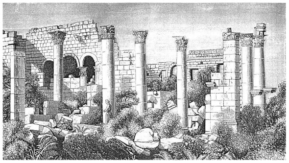
We now turn our attention to Gilead, the district lying south of the river Yar'mûk, and extending as far south as the head of the Dead Sea. In this entire district there is only one inhabited city, and there are but very few villages. Its most extensive ruins are those of Jerash', a city which stood in the northeastern part of the district, at the head of a northern branch of the river Jabbok, and about 25 miles east of the Jordan. The walls of this ruined city are almost entire in places, and are traceable on all sides. They included a space of irregular shape, a little more than half a mile long from north to south and about the same in width at the widest part, which is near the southern end. A stream of water fed by springs runs through it from north to south, dividing it into two unequal parts, the larger part toward the west. The spring which is the chief supply of the stream, bursts forth from under a perpendicular ledge of rock inside the northern wall, and a level bench near it on the bank of the stream is the uniform camping-place for travelers. The stream is hidden along its entire course by a thick jungle of oleanders nearly 20 feet high, but the sound of its waters, as they dash over rocks obstructing the channel, is distinctly heard.
The city is intersected from north to south by a street 17½ feet wide, running nearly parallel with the stream. It runs along a bench on the slope west of the stream, and it maintains a level all the way. Its ancient pavement of flagstones is entire in many places, and along each side of it there was a continuous row of Ionic columns with richly-carved entablatures resting on their capitals. About 100 of these are still standing; the pedestals of nearly all are in place; and you make your way with some difficulty along the street among the scattered blocks of those that have fallen. About half-way the length of this street it is intersected at a right angle by another from an eastern gate, which crossed the stream on a massive stone bridge, now in ruins. Farther toward the south it is intersected by another street from a western gate, and at the point of intersection there is a double archway supported by four piers, allowing each street to pass through an arch at a right angle to the other. This colonnade street terminates, at its southern end, in a grand forum in the shape of an ellipse. It was surrounded by a row of columns like those which line the street, and 55 of these are still standing. Farther up the slope, along the western [362]
 |
| SOUTHERN GATE, OR TRIUMPHAL ARCH OF JERASH. |
| Page 363. |
side of the colonnade street, are the ruins of several magnificent heathen temples, many of whose columns and walls are still standing. There are also two amphitheatres, whose stone seats are so well preserved that almost a full audience could now be seated upon them. The larger of these was capable of seating 5000 spectators. The western side of the city, at the time of its destruction, seems to have been chiefly heathen, and the eastern chiefly if not entirely Christian; for all the heathen temples are on the western side, and on the eastern the author counted the ruins of five churches inside the walls and one outside, to the south. Three stone bridges across the chasm of the little stream connected the two sides, and one of these, though in a dilapidated condition, can still be crossed by animals.
Almost the entire space within the walls of the city is covered with heaps of building-stones and prostrate columns, and all around the walls outside are broken sarcophagi and rock-hewn sepulchres, the burial-places of Jews, heathen, and Christians. The principal cemetery was south of the city, and the remains of dwellings as well as tombs here cover quite an extensive area. About a quarter of a mile south of the original city-gate stands a structure which may have been a triumphal arch, or may have been the gateway of a southern addition to the city,--more likely the former. Its south front is presented in the cut on the opposite page. Its entire width is 82 feet, and the height of the central arch is 29 feet. If it was a gateway, the two side arches were intended for the passage of persons on foot.
On the western side of the road leading north from this structure lies a large basin 230 yards in length and 75 yards wide, walled with excellent masonry. A surface-channel drawn like a mill-race from the stream near the upper end of the city supplied it with water. It is supposed by some that it was intended as a Naumachia, a place for mimic naval battles, and remains of tiers of stone seats at the upper end confirm this view. Such exhibitions must have possessed peculiar attractions to a people remote from the sea-board.
It would require many pages of this book to give a full description of the ruins of this city, and even then but a faint conception of its ancient grandeur would be conveyed. It was anciently known as Ger'asa, and Jerash' is but an Ar'abic corruption of this name. It belonged, like Gad'ara, to Decap'olis, and some suppose, from its situation and importance, that it is the Mahanaim of the Old Testament.56 [363] Its most prosperous period was after the Christian era, and in the fourth century it was regarded as one of the largest and strongest cities of Arabia. It is spoken of as a deserted city as early as the thirteenth century, and consequently the ruins which we now behold there, though they are neither weather-stained nor covered with earth, have remained in their present condition for more than 600 years. It is probable that an earthquake first destroyed the city, and that its reconstruction was prevented by the fact that tent-dwelling Ar'abs afterwards held possession of the country, as they do to the present day.
About 25 miles southwest of Jerash is Es Salt, the only inhabited city in Gilead. About half-way between the two cities the road crosses the river Jabbok at a ford. In the vicinity of the ford are the remains of ancient water-mills, which have gone to ruin through the neglect of the Bed'awin inhabitants. The mountains south of the ford, and extending as far as Es Salt, are called by the Ar'abs Jebel Jilâd' (the Mountains of Gilead), and those to the north, Jebel Ajlûn. The highest point in these mountains lies a mile and a half to the west of the road as we approach Es Salt, and it is called Jebel Ow'sha57 (the Mountain of Hose'a). Its name is derived from the tradition that the prophet Hose'a was buried on its summit, and the traditional place of his burial is marked by a Mohammedan tomb. A trough built of stone, 31 feet long and 3 feet wide and deep, is called the Prophet's Coffin. It is overhung by a pall of dirty woolen goods in broad stripes of blue and red, and it lies in a long, low, and narrow room, with very small openings in the wall to admit a dim light. A little square structure with a plastered dome over it (the usual Mohammedan wel'y) stands at the western end of the tomb, and by the side of this is a good rock-hewn cistern containing water. The tomb had no guardian when visited by the author, though there is a room attached intended for the accommodation of one. A Mohammedan graveyard surrounds it, and near its eastern end stands a magnificent oak, whose foliage extends evenly around on every side and covers an area 62 feet in diameter. It reminds one of the words in which the prophet whose remains are said to lie near it once rebuked the idolatries of Israel, saying: "They sacrifice upon the tops of the mountains, and burn incense upon the hills, under oaks and poplars and elms, because the shadow thereof is good."58 The summit of this [364] mountain is 3470 feet above the level of the sea, the highest point on the east of the Jordan. It rises precipitously from the Jordan Valley, which lies in full view for many miles up and down the river, while the mountain-slopes west of the river can be distinctly traced from the Dead Sea to the Lake of Galilee. Beyond the lake to the north rises the snow-covered summit of Mount Hermon, appearing, on account of the distance, not much above the level on which you stand. This is the most wide-spread and magnificent view of the country obtainable from any point east of the Jordan, not excepting that enjoyed by Moses from the top of Pisgah, and on this account some earlier travelers took this to be the latter mountain.
Between Jebel Owsha and the river Yar'mûk stretches the long range of Jebel Ajlûn', which is crossed by many interesting wâdies and contains many ruins of minor importance. Only one Scripture locality has been identified here, and the identification of it needs confirmation. It is Jabesh-Gilead, which Dr. Merrill identifies with Miryamin.59 It is a ruined city overlooking Wâd'y Yâ'bis, which is about half-way between the Jabbok and the Yar'mûk. The name Jabesh is probably preserved in that of the wâdy, Yâ'bis, but not in that of the town.
Es Salt is supposed to be the Ramoth-Gilead of the Scriptures, the city near which Ahab was slain in battle, and Jehoram, his son, wounded in a subsequent battle. There, too, Jehu was anointed, and thence he rushed forth on his famous drive to Jez'reel, where he slew the king of Israel and the king of Judah.60 Its modern name is derived from the Latin saltus, a wood-covered mountain, the Es being the Ar'abic article.61 Its identification with Ramoth-Gilead is not established beyond a doubt. The natives claim for it a population of 12,000, but it is usually set down by European visitors at 3000,--a very low estimate. The people are chiefly Mohammedans, but a portion are Greek and Roman Catholics. The latter Church has a convent with schools attached, and the Church of England has a mission-station and school under the control of the Bishop of Jerusalem.
The town is picturesquely situated on the eastern side of a very steep hill, and the houses rise one above another like steps. More than half the town is built of sun-dried brick; the walls of the houses are plastered with a brown mortar, and the roofs are of the same material. These houses were compared by one of the author's party to large [365] "dirt-daubers'" nests stuck on the hillside. The newer part of the town is built of a yellowish limestone, and some of its houses present a rather pleasing appearance. A very copious spring issues from the rock, near the foot of the hill, runs in several babbling streams along the streets below it, and thence passes into channels to irrigate gardens in the valley below. This valley, starting from the city in a southern direction and afterward turning westward, passes out into the Jordan Valley at the upper end of the Plain of Moab, and there it has the name Wâd'y Nimrîm'.
The summit of the mountain on which Es Salt is built is crowned with a massive castle, once the "stronghold" of the city, but now in ruins. It is 2740 feet above the level of the sea. The tillable land in the vicinity of the town for several miles around is well cultivated, and the vineyards are quite extensive. This is the only section of Gilead in which the vine is now cultivated at all. The vines are allowed to run flat on the ground.
The next point usually visited by the traveler after leaving Es Salt is Ammân', the ancient Rabbath-Ammon. It was called Philadelphia during the period of Roman dominion. The distance to it from Es Salt by the road is about 20 miles, and the direction is nearly southeast. The country between the two places is a high, undulating table-land, very rich, and containing many extensive grain-fields cultivated by the Bed'awin. The ruins of towns and cities are seen on every hand.
The ruins of Ammân' are scarcely less massive and extensive than those of Jerash'. They are situated chiefly on the western bank of the river Jabbok, which here runs due north. There was an upper and a lower city, the latter lying on the low ground adjacent to the river-bank, and the former on the summit of an isolated hill 300 feet high, with sides almost perpendicular. A strong wall around the brow of the hill made it almost impregnable. The greater part of the wall is still standing, and the space within is covered thick with a confused mass of ruined buildings and the stones of prostrate walls. Immense rock-cut cisterns and one circular reservoir 58 feet in diameter and of unknown depth show the care that was exercised to supply the place with water. The almost perpendicular sides of the mountain toward the lower city are full of sepulchres.
In the lower city the principal street ran parallel with the river, between it and the foot of the hill, and it was lined on both sides by blocks of small houses for shops, alternating with public buildings of various kinds. The various phases of the city's history are suggested by the ruins of a heathen temple, a Christian church, and a [366] Mohammedan mosque, all massive and grand, standing on this street but a few steps apart.
While the lower city was chiefly built on the western bank of the stream, there were some public buildings of importance on the eastern bank. Among these was an amphitheatre, whose space was cut into the side of the hill which rises to the east, and whose stone seats could accommodate 6000 spectators. Most of these seats are yet there and ready for use. Near by is a smaller theatre, more properly an ode'on, a place for musical entertainments, which is in a still better state of preservation, and between the two structures are many columns whose significance is not easily perceived. The river is spanned by several arches, and its banks are lined for a considerable distance with solid walls of masonry. It is a small stream, but it has cut out many basins in the rock from two to four feet deep, and these are alive with beautiful fish, many of them from eight to ten inches in length. The source of the stream is about a mile and a half southwest of the ruins, where it rises out of the earth through a large bed of pebbles and coarse gravel. So buoyant is the water as it pushes its way up through the pebbles that a horse's feet sink among the pebbles almost as in a mass of mud. The stream is almost as large in the summer immediately below the source as it is in the Jordan Valley just above its mouth, for, although it receives many small tributaries in its course, it also gives out many small streams to the irrigating channels by which it is tapped.
The two cities into which Ammân', or Rabbah, as it is most frequently called in the Scriptures, is divided, accounts for the very singular message sent to David by Joab when he was besieging the city. He said: "I have fought against Rabbah, and have taken the city of waters. Now, therefore, gather the rest of the people together and encamp against the city and take it, lest I take the city, and it be called by my name."62 He had taken the lower city, through which the river flowed, and which was for this reason called "the city of waters," and the fall of the upper city, now cut off from these waters, was only a question of time. The siege by Joab was in progress at the time of David's great sin against Uriah the Hittite, and it was here that Hanun, the young king of the Ammonites, had committed the outrage on David's ambassadors which led to this war.63
Ammân' is situated on the extreme verge of the tillable lands of Gilead, and beyond it to the east lies the desert. High hills and long [367] ridges are seen in the distance eastward, but all appear barren and desolate. The copious fountain-head of the Jabbok, and the stream which flows from it, render the vicinity of the city a kind of oasis in the long dry summer, and the Bed'awin congregate here in large numbers with their flocks and herds. The largest encampments of these people that the author saw in any part of the country were here, and in a single days ride he saw four or five hundred camels and four or five thousand sheep and goats, besides a goodly number of black cattle.
From Ammân' the traveler usually rides in a direction a little west of southwest to Arak-el-Emîr', or to Heshbon, which lies a little south of southwest. If both places are visited, the former is taken first. The distance to either is about 20 miles, and they are about 10 miles apart. Arak-el-Emîr' is the Ar'ab name of a castle, with some adjacent buildings and tombs, which was built here by Hyrcanus, the son of Joseph, in the year 180 before Christ. Josephus gives an elaborate account of its construction,64 and its ruins correspond to the description. Professor Merrill says of them: "These ruins are among the most interesting in Syria. Here are some of the largest stones I have ever seen in Syria outside of Baalbec; here also was one of the largest reservoirs in the country; it was almost a lake; when it was full of water ships could easily float there. Nowhere have I seen a wall of such strength as the one to the south and east of this reservoir."65 The walls of the castle were built without mortar, the stones being fitted closely together and held in their places by depressions on the surface of one, into which fitted corresponding projections on the bottom of the one above. The cut on the opposite page represents the entrance to the castle as it now stands.
In approaching Heshbon, now called by the natives Hasbân', from the direction of Ammân', we descend from the elevated plateau, over which the road runs most of the way, into the dry and rocky bed of Wâd'y Hasbân'. This leads to a splendid spring called Ain Hasbân', which rushes from under the rock on the side of that wâdy, and descends into and across the Jordan Valley. Below the spring the wâdy widens out into a beautiful little valley, which is a favorite camping-place for tourists and also for the Ar'abs. At the time of the author's visit the family of our escort, Sheikh Fellâh', and a large number of his tribe were encamped there. Our tents were pitched in the midst of theirs. Within a half-mile below our camp we saw the [368] ruins of three mills once propelled by the water from the spring, and the mill-races, now used exclusively for irrigating purposes, are still preserved. The Bed'awin have allowed all the mills in the district which they occupy to go to ruin.
To reach the site of Heshbon from the spring, we pass along the wâdy-bed southward about a mile, when it turns abruptly to the west, and we climb its precipitous southern side to the level of the highlands of Moab. The ruins of the ancient city are situated on the summits
 |
| ENTRANCE TO CASTLE OF HYRCANUS. |
of two high hills standing east and west from each other, and on the saddle connecting the two. The eastern hill is the highest for many miles around, and it is crowned with the ruins of a very ancient castle. The view from this point is wide-spread and full of interest. To the north Es Salt is distinctly seen, though more than 20 miles distant in an air-line. To the west the eye ranges over the entire length of the mountains of Israel; to the east a broad level plain is bounded in the horizon by the higher surface of the desert; while to the south a plain of surpassing beauty and fertility lies spread at your feet and [369] stretches away to a distance of 20 miles or more. This plain reaches out eastward to the desert, and westward to the rugged peaks and ridges which overhang the Dead Sea; and everywhere it is dotted with rounded hills, many of which are crowned with ruins. Here old King Sihon, standing on his lofty battlements, could see the hosts of Israel for 20 miles away as they approached from the south, led by the pillar of cloud, and as he looked around upon the entire area of his own fair domain, it is not surprising that he refused to allow the invading millions a passage through his land. Between the point on which he stood and the hills overhanging the Dead Sea, only six miles to the west, that host must pass in order to reach the Jordan Valley, and there they did pass, but not until the army of Sihon, which met them on the plain, had been annihilated.66 Among the ruins of Heshbon, as in all places thus situated, there are many rock-hewn cisterns, and in the plain near the foot of the hill to the southeast is a very large reservoir, well walled, but now nearly filled with earth.
There are very few places south of Heshbon that have a Scripture history, though there are many ruins and some places of interest which have a history outside the Bible. One of the most interesting of these is the group of hot springs in Wâd'y Zerka Mâ'in, a deep, narrow gorge, which descends from the highlands into the Dead Sea, about eight miles below its northern end. The banks of this wâdy, for seven miles above its mouth, are walls of rock, in many places perpendicular, and about 1000 feet high. It is impossible to ride down to the bottom of it, except in a very few places. One of these is on the northern bank, in the very midst of the springs. The rock of the southern wall of the chasm is basalt, as black as iron. On the northern side it is red sandstone to a height of 100 feet or more, with limestone above. The hot springs, 10 in number, issue from between the ledges of sandstone and limestone, and dash down the precipice in numerous cascades and rapids. The two principal springs are about half a mile apart, and each sends forth a volume of water sufficient to run a mill. The springs vary in temperature from 130° to 143°, the most western of all having the latter temperature. The cool stream of water which flows along the bed of the chasm is about doubled in volume by the accession of these hot streams, and its temperature is raised to about 90° but ere it reaches its mouth it is reduced to 70°.67
These springs were resorted to by Herod the Great during his last [370] sickness, in the hope of benefit from their medicinal properties,68 and it has been supposed that baths after the Roman fashion were constructed here. If they were they have long since disappeared, and they may be covered by the mounds of sulphurous deposit from the water. These have accumulated to nearly 100 feet in depth in some places, and they have caused a considerable contraction of the width of the valley.
In the mountains above the springs to the south are the ruins of the castle of Machærus, in which John the Baptist was beheaded.69 It was a very strong fortress, on an almost inaccessible mountain-top, built originally by Hyrcanus, and afterward greatly strengthened and enlarged by Herod. Canon Tristram found among the ruins two dungeons cut in the rock, one of which he thinks was certainly the prison of John the Baptist.70 The strength of the castle and its siege by the Roman general Bassus are fully described by Josephus.71 It is now called Mkaur, and it is 3800 feet above the Dead Sea.
The only other place north of the Arnon which demands mention here is Dibân' (the Dib'on of Scripture), and it is worthy of mention, not so much from its intrinsic importance as because here was found the celebrated "Moabite Stone." This is a block of basalt three feet long and two feet wide, with one side covered by a Moabite inscription. It was discovered among the ruins of Dib'on in 1868 by F. A. Klein, a missionary of the English Church, but through some delay and mismanagement the Ar'abs in the vicinity became aware of its value before it was removed, and, angry at the probable loss of it, built a fire under it, threw cold water on it when it was red-hot, and broke it to pieces. The fragments were finally recovered and brought to the Museum of the Louvre in Paris. It is a record made by Me'sha, the king of Moab, a part of whose history is given in the third chapter of Second Kings. It gives an account of wars previously waged by Me'sha against Omri, king of Israel, and his son Ahab, and also of certain cities in his own territory which he built, and of some which he improved. It is the oldest Semitic writing known to be in existence, having been written 3000 years ago, buried out of sight, and now speaking as with a voice from the grave concerning men and cities and events mentioned in some of the older books of the Old Testament. It is a specimen of what the Moabites were thinking and saying on their side of the question, while the Israelites were thinking and saying [371] on their side as represented in the books of Kings and Chronicles.72 Dib'on, the ruin in which it was found, is on the eastern border of Moab, and but a short distance north of the river Arnon.
A few miles south of the Arnon, and in the midst of the mountains overlooking the Dead Sea, is the famous city and fortress of Kerak'. It is a level rock-summit surrounded on all sides but the eastern by chasms from 800 to 1000 feet deep, with perpendicular sides. A well-built wall surrounds the brow of the precipice on every side, and the only two places of entrance are through arches tunneled in the solid rock from the side of the precipice to the level within. These entrances are approached by paths cut in the rock, which are barely wide enough for an approach of men or beasts in single file. It is the headquarters of the tribe of Ar'abs called Beni Sukrh, one of the most lawless and independent of all the Bed'awin tribes in Syria. It is the Kir-hareseth of Scripture, into which Me'sha, the king of Moab, took refuge after his army had been cut to pieces by the combined forces of Israel, Judah, and Edom; and the strength of its fortifications, even at that early period, is indicated by the fact that with but a handful of men the Moabite king succeeded in defending himself against an overwhelming force.73 The present population of the city is stated at 8000, of whom 1600 are Christians of the Greek Church. The best description of the place is given by Canon Tristram. He and his party were detained there as prisoners four days, with the hope of extorting from them a large sum of money. They were not able to give the amount demanded, and they refused to give any at all. They were finally released through fear of the Turkish authorities.74
We now return to the vicinity of Heshbon, and will conclude this section with an account of Mount Nebo and "the top of Pisgah." As one stands upon the heights of Heshbon and looks around for Mount Nebo, he instinctively fixes his eye upon some of the lofty peaks far away to the south; for we always magnify in our imagination famous objects which we have never seen. It is with a feeling of disappointment, then, that when we call for Mount Nebo (Jebel Nebâ' is its Ar'ab name) our Ar'ab guide points to a round mountain-top about six miles to the west, whose height is less than that of the eminence on which we stand, and much less than that of mountains a few miles distant both to the south and the north. Having ridden to the summit pointed out, we [372] find it so smooth as to be tillable, with gradual slopes on every side but the north; but, on comparing the view with that ascribed to Moses in the thirty-fourth chapter of Deuteronomy, we find that it fails in two points. "The south," the low country lying south of the mountains of Judah, is not visible, because a high mountain a few miles south of us, which juts out nearer to the Dead Sea, shuts it off. Neither is "the plain of the valley of Jericho" in full view, for only a small portion of its southwestern part is seen, while the site of Jericho itself is shut off by a lower spur of Mount Nebo. These points of failure led Professor Payne, of the American Palestine Exploration Society, to look farther for the actual spot on which Moses stood. In addition to its main crest, Mount Nebo has two lower spurs, or knobs, one due west and the other a little south of west from the main crest, connected to the latter and to each other by low intervening saddles. From the former of these called Jebel Siâghah, on whose summit are the ruins of a heathen temple, the entire Valley of Jericho is in full view, and also the entire Plain of Moab; but "the south," which was seen by Moses, is still shut off by the intervening mountain above mentioned. The other knob, which is due southwest of this and of equal height, is the next resort, and here all the requirements of the Scripture text are met. The plain of the Jordan on both sides of the river is seen as distinctly as from the second point, and on looking south we find that we are now far enough westward to see around the point of the intercepting mountain south of us, and there, in the horizon, is the long curve by which the high mountains about Hebron descend into the lower "south country," and a portion of the latter comes into view. This knob, then, is the Pisgah on the top of which Moses stood to obtain his last view of the Promised Land. It is said that he went up from the plains of Moab into the mountain of Nebo to the top of Pisgah that is over against Jericho,75 and here is Nebo with a Pisgah (height) as its most western summit, the only summit from which all can be seen which Moses saw.76
The disappointment which one experiences on observing that this famous mountain is lower than some others near it is removed when we descend to the plain below, and look back at it from the point at which Moses stood when he was commanded to ascend it. Here, on account of its greater proximity to us, it appears fully as high as any [373] adjacent mountain-top, and to the eyes of Israel, who were camped here, Moses appeared to ascend one of the highest mountains in the Moab range. They could all see him from their tent-doors up to the moment that he ceased gazing upon the Promised Land and laid himself down to die.
The reader should here be cautioned against a misunderstanding of one statement concerning the view enjoyed by Moses. It is said that the Lord showed him "all the land of Judah to the utmost sea."77 This clause has been construed as if it stated that he saw the sea itself; but it does not so state, neither is this possible, for the intervening mountains are too high and the distance is too great for the actual surface of the sea to be visible. The range of vision, however, reaches as far as the sea without bringing the sea into view, and this is all that the text asserts.
When the author and his party had satisfied themselves with the view from the top of Pisgah, and had indulged in such reflections as were naturally inspired by standing where Moses stood and viewing the same landscape o'er, we directed Sheikh Fellah' to lead us to our tents, which had been pitched at the Springs of Moses, on the northern side of Mount Nebo, 1100 feet below its summit. We expected, from the apparent steepness of the descent, a very steep and fatiguing ride; but to our surprise and gratification he led us by a path that was smooth and easy almost the entire way. It is probably the same path mentioned by Professor Payne in the essay already referred to. The Springs of Moses are a group of springs which issue from the rocky side of Mount Nebo, rush down into the narrow bottom of the valley called Wâd'y Mûsa (the Valley of Moses), making several beautiful cascades on their way, and thence flow westward into the Jordan. Nothing was known by Europeans of this wâdy or these springs until a few years ago; but the name has lingered among the native inhabitants through all the dark ages of the past, and now it comes to light to confirm, by the evidence of local tradition, the Bible record, which fixes here the closing event in the life of Moses. The most practicable route from his tent in the plain to the top of Pisgah was by way of these springs, and it was here, most probably, that he quenched his thirst for the last time ere he closed his eyes in a mysterious death. [374]
[LOB 339-374]
|
[Table of Contents] [Previous] [Next] |
J. W. McGarvey Lands of the Bible (1881) |
|
Send Addenda, Corrigenda, and Sententiae to
the editor |