 |
| MOUNT SINAI. |
| Page 448. |
|
[Table of Contents] [Previous] [Next] |
J. W. McGarvey Lands of the Bible (1881) |
L E T T E R V I.
THE PENINSULA OF MOUNT SINAI.
SU'EZ is the point from which travelers now set out on the journey to Mount Si'nai and the desert of the wanderings of Israel. We did not take this journey, for the reason that it would have required nearly forty days of laborious and expensive travel to see only a few places of interest, and these have been so thoroughly explored and described that we thought it of comparatively little importance to visit them. But our present task would not be complete without an account of this region.
In the fall of 1868 a corps of British engineers, under the joint command of Captains Wilson and Palmer, was sent to Mount Si'nai for the purpose of surveying scientifically its vicinity, and of examining carefully all of the routes by which it is possible for the children of Israel to have reached it. The Arabic scholar and interpreter for the party was E. H. Palmer, professor of Arabic in the University of Cambridge, and from his pen, after the work had been executed, appeared a book entitled "The Desert of the Exodus," which is the most reliable and authoritative account of the country that has ever been published. It was published at Cambridge in 1871, and republished in New York by Harper & Brothers in 1872. From it I have chiefly compiled the matter of this letter, though I have not slighted several other excellent works on the subject.
In our general description of the land promised to Abraham,1 we have stated that its boundary in the direction of Egypt was a line drawn from the mouth of Wâdy el Arîsh, at the southeastern curve of the Mediterranean Sea, straight across to the head of the Gulf of Ak'abah. The region lying south and west of this line now demands our attention. It is divided into two distinct districts,--the desert at the north, called by the Ar'abs et Tîh (the wandering), and the peninsula of Mount Si'nai, [444] to the south. The former is an elevated desert with a gravelly surface, interspersed here and there with sharp ridges of rock, and sloping gradually northward toward the Mediterranean Sea. It is about 150 miles wide at its southern end, and it measures 140 miles north and south. The latter district is the peninsula lying between the two "horns" of the Red Sea, the Gulf of Ak'abah on the east and the Gulf of Suez on the west. The length of the former is 130 miles, and that of the latter is 190 miles.
The peninsula, then, is a triangle whose base from the head of one gulf to that of the other is 150 miles, whose eastern side is 130 miles, and whose western side is 190 miles in length. Within this triangle occurred most of the events recorded in the history of the forty years' wanderings, although here Israel spent but little more than one year. It is now an almost uninhabitable desert, occupied only by a few Bed'awin Ar'abs, a few Greek monks in a convent at Mount Si'nai, and a few Egyptian soldiers in a fortress at the head of the Gulf of Ak'abah. Its surface consists of mountains of naked rock, chiefly granite, some of them more than 8000 feet high, narrow valleys between the mountains, a narrow coast plain along the Gulf of Suez, and some elevated plains of gravel near the base-line of the triangle. It is so nearly destitute of water that travelers passing through are compelled to carry water with them over long distances, and the Nile water, carried in skins on the backs of camels, is often the best water found on the route as far as Mount Si'nai. Vegetation is found only in the vicinity of springs and in the wâdy beds, where water flows in the winter and percolates underground in the summer. The climate is tropical in the valleys, but in winter the mountain-tops are often covered with snow, and the great difference of elevation renders the temperature quite variable to the traveler as he passes alternately over high mountains and deep valleys.
The route from Suez to Mount Si'nai follows the gravelly plain along the coast of the Gulf of Suez the chief part of the way. This plain is about 12 miles wide, and lies about 100 feet above the level of the gulf. It is bounded on the east by the mountain-wall which rises to the general level of the interior. The children of Israel, after crossing the Red Sea, commenced their journey from the Springs of Moses, described in our last letter, and this mountain-wall on their left gave the Scripture name Shur (the wali) to the first desert track through which they journeyed.2
The first stage of Israel's journey in this plain is thus described in [445] Exodus: "So Moses brought forth the children of Israel from the Red Sea; and they went out into the wilderness of Shur; and they went three days in the wilderness and found no water."3 The first stage of the journey made by the British exploring party is described by Palmer in these words: "From the Wells of Moses we traversed an unvaried desert plain for three days: there is nothing to attract attention but the bleached camel-bones that mark the track, and nothing to afford reflection but the thought that, like the children of Israel, you have gone three days in the desert and have found no water."4
On the third day Palmer reached 'Ain Hawwar'ah, as travelers generally do, and found it, as all others have, "a solitary spring of bitter water." The bitterness of the water varies at different seasons, and some travelers have found it palatable. This is unquestionably the bitter water of Ma'rah, which was sweetened by Moses.5 The Arabic name signifies a small pool whose water is unfit to drink.6
The next watering-place of Israel was at Elim, where were "12 wells of water and threescore and ten palm-trees." The time required to reach it is not stated.7 It took Robinson two hours and a half, the distance being about seven miles. It is now called Wâ'dy Ghâr'andel. Robinson found it dry, but he says that water is found by digging a little below the surface. He saw a few small palm-trees scattered through the valley.8 Dr.Ridgaway saw two or three streams of water running along the valley, and counted 46 palm-trees within a short distance below his camp.9 Palmer, in approaching it, says, "A little farther on the eye is again refreshed by the sight of green tamarisks and feathery palms, and just off the customary track is a pleasant stream of running water."10 When the place was reached by Israel the stream had probably sunk, as when seen by Robinson, and the 12 shallow wells had been dug to reach the water.
After leaving Wâd'y Ghâr'andel (Elim) the road is shut off from the seashore by a coast-range of mountains, which rise from the water's edge, and you ascend over a rocky elevation between this range and the higher mountains of the interior. This coast-range is called Jebel Hamman' Far'un (the mountain of Pharaoh's hot spring) from an Ar'ab tradition which accounts for a hot spring at its base by the supposition that the spirit of old Pharaoh is confined there. The road next descends into Wâd'y Taiyebeh, which runs out to the seashore at the southern [446] end of this mountain. This corresponds with the statement in Numbers xxxiii. 10 that "they removed from Elim and encamped by the Red Sea." This is the only practicable route by which they could reach the seashore, and it is only one days journey from Elim. But on reaching the shore they entered once more upon the coast plain, which had been interrupted by the mountain they had compassed, and the long, narrow strip of smooth plain before them must be, as the name indicates, the wilderness of Sin; and this agrees with the statement in Exodus, parallel to that just quoted in Numbers, that "they took their journey from Elim, and all the congregation of the children of Israel came unto the wilderness of Sin, which is between Elim and Si'nai."11 It was while they were traversing this plain that the first flight of quails was sent to them, and that the manna commenced falling.12
From this plain it was necessary for Israel to ascend through the rugged granite mountains to the elevated plain in front of Mount Si'nai, and there is only one pass through and up by which it is practicable for such a caravan to make the ascent. This is Wâd'y Feirân', whose mouth is nearly 40 miles by the route of travel southeast of that of Wâdy Taiyebeh. This wâdy is wide and smooth, washed in winter by a stream of water, and possessing several beautiful oases very pleasing to a traveler who is wearied with the almost uninterrupted barrenness of the desert. It leads to a narrow and short pass, by which is reached the plain immediately in front of Mount Si'nai, called by the Ar'abs Er Râ'hah. Instead of reaching this plain by this pass, the Israelites might have gone a little farther east and compassed the mountain on the left of the pass, but this is the only divergence that they can have made from the route which we have followed. Such was the unanimous conclusion of the British engineers and explorers, the only men of modern times who have visited the region with the leisure, the facilities, and the other qualifications necessary to a final settlement of such questions. The route of travel is now as accurately determined as any of which we have any account in ancient history.
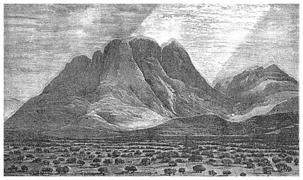
The plain Er Râ'hah, just mentioned, is about two miles long and half a mile wide. Its two extremities point to the northwest and the southeast. At its southeastern extremity it terminates against the front of Mount Si'nai, which rises from it abruptly, a naked and almost perpendicular mass of granite, 1800 feet high above the plain and 7359 feet above the sea. The mountain is described as "a huge block about two miles in length and one in breadth, with a narrow valley on [447] either side, a somewhat lower one at the southern extremity, and a spacious plain (Er Râ'hah) at the northwestern end."13 Our cut represents this plain with the mountains front rising from its farther extremity.
The surrounding valleys of this isolated block are themselves surrounded by mountains, one of which, Mount St. Catharine, to the southwest, is more than 1000 feet higher than Mount Si'nai, being 8526 above the sea level. This is the highest point in the peninsula. The latter was selected rather than the former for the majestic scene of the giving of the law, because about its front was an open space for the people to occupy not found near the loftier mountain. Captain Palmer and his assistants made an exact calculation of the space in this plain, and found that it contains two millions of square yards, and that it was capable, therefore, of accommodating two millions of spectators, with one square yard to every one.14 But besides this level space, the people may have occupied the mountain-slopes on every side, and doubtless many of them preferred such a position on account of the more commanding view which it afforded, both of the mountain on which God had descended in fire and smoke and of the vast multitude of the people. Here, at least, may have stood all who could not find room on the plain, even if the number had been double that which the plain could accommodate.
At the time of the majestic scene in question, the camp of Israel was not on the plain in front of the mountain, but farther away to the north, for we are told that "Moses brought forth the people out of the camp to meet with God, and they stood at the nether part of the mountain."15 No grander sight ever greeted human eyes, or overwhelmed the human heart, than was witnessed by Israel that day. The granite mountain was first covered with a thick cloud, from whose bosom the lightnings flashed and the thunders pealed, while above this fearful din there arose "the voice of a trumpet exceeding loud." Then, after the people had all assembled, "Mount Si'nai was altogether on a smoke, because the Lord descended on it in fire, and the smoke thereof ascended as the smoke of a furnace, and the whole mountain quaked greatly." Meanwhile, "the voice of the trumpet sounded long, and waxed louder and louder."16 Such was the view on the mountain-top, while scarcely less sublime was the view of the countless throng of human beings, arrayed in garments clean and white,17 and standing in solemn [448]
|
| MOUNT SINAI. |
| Page 448. |
awe on all the plains and mountain-sides as far as the eye could reach. Only Xerxes ever gazed in full view on a mass of human beings comparable in number, and he, heathen tyrant as he was, burst into tears at the sight. In all probability no other such assemblage will be seen again until that day when not one nation, but all, shall stand before God in judgment.
The configuration of Mount Si'nai not only agrees with the Scripture narrative, but it furnishes some of those very striking coincidences in minute matters which show the pen of an eye-witness in the narrative. The singular warning is said to have been given to Israel, "Whosoever toucheth the mount shall be surely put to death: there shall not a hand touch it but he shall surely be stoned, or shot through; whether it be man or beast, it shall not live."18 Such a warning, in the case of the most of mountains, would be an utterly impractical one, because it would be impossible to tell, on account of the gradual subsidence of the mountain into the plain, just where the one begins and the other terminates. But, as we have said before, Mount Si'nai rises abruptly from the edge of the plain,--"so abruptly," says Professor Palmer, "that you may literally stand under it and touch its base."19 Who but an eye-witness of the scene could have assumed this fact in his narrative?
Again, it is usually the case that a man descending from a mountain-top toward a plain at its base can look out over the plain and see all that is occurring on its surface. But when Moses and Joshua were coming down together from Mount Si'nai, they heard "the noise of the people as they shouted," Joshua thinking it was "the noise of war, and Moses insisting that it was "the noise of them that sing," but neither of them was able to see what it was until they came "nigh unto the camp."20 If this narrative is true, it must be owing to some peculiar configuration of the mountain by which the path of descent was hidden from the plain, although it was within hearing distance. Now, Professor Palmer describes a path up the. mountain along a ravine, "the most convenient and quickest road" from his camp in the plain, and he says of it: "Often in descending this, while the precipitous sides of the ravine hid the tents from my gaze, have I heard the sound of voices from below, and thought how Joshua said to Moses as he came down from the mount, 'There is a noise of war in the camp.'"21
The high elevation of this region, together with the differences of [449] temperature between the mountain-tops and the deep valleys between, causes the frequent occurrence of sudden and violent storms. The experience of the British exploring party in this particular is humorously described by Professor Palmer in the following passage:
"Camp life in these latitudes is the most healthful and enjoyable thing possible, but it has its vicissitudes too. One must expect now and then to find one's self buried beneath the débris of an uprooted tent, to behold one's dinner hopelessly mixed up with sand which a sudden storm brings on, or to be obliged to turn out barefoot in the cold and rain to slacken the tent ropes. A whirlwind is the most curious of all the visitations to which one is exposed; it is as violent as the most awful storm, tearing up everything in its path, but it is so partial that you may stand a yard or so off and watch its progress undisturbed. When, as once happened to me, it is your neighbor's tent which is blown about his ears, while your own canvas is motionless, there is a great satisfaction to be derived from witnessing this strange atmospheric phenomenon. Such little casualties, however productive of indigestion and rheumatism they might be in our northern climes, are rather amusing than otherwise in desert life; but, like most luxuries, they must be enjoyed in moderation, or they are apt to pall upon the taste."22
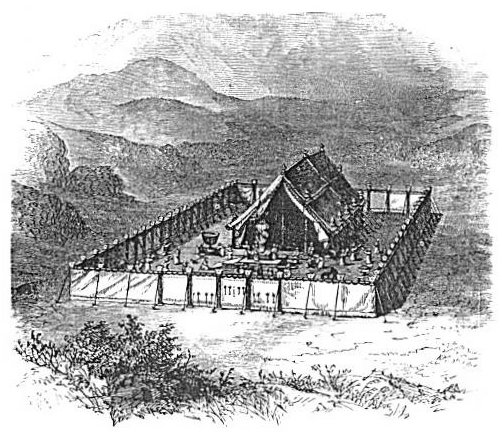
Such incidents, resulting from unchanged physical causes, must have occurred in the experience of Israel, and an earlier knowledge of them would have prevented scholars from forming the old and now obsolete conception of the tabernacle as a structure covered with curtains loosely thrown over its top and hanging like a pall around its sides. The cut on the opposite page, representing its construction as now understood, agrees much better both with the nature of the climate in which it was pitched and with the Scripture text in which it is described.
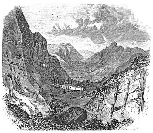
Mount Si'nai, on account of the awful scenes connected with the giving of the law, has been regarded ever since that event as one of the most sacred places on the earth. Consequently, when monasticism first sprang into existence in Europe, a swarm of monks and hermits gathered about this mountain, as about many others in Bible lands, and made here their humble dwellings in natural and artificial grottos on the mountain-sides. To accommodate and protect these fanatics the Emperor Justinian in the early part of the sixth century, erected for them a convent on the eastern side of Mount Si'nai, near its base.23 [450] There it has stood to the present day, a curious relic of a superstitious age. It is called the Convent of St. Catharine, from the circumstance that on the beheading of a saint by this name in Alexandria her body was borne away by angels to the top of the adjacent mountain,--thence called Mount St. Catharine,--and that from the top of this mountain it was brought down by the monks and buried in the convent. The cut
 |
| THE TABERNACLE. |
on the following page represents this convent, with Mount Si'nai rising above it to the left and the plain Er Râ'hah in the distance.
Here successive generations of monks of the Greek Church have lived for fourteen centuries, supported by an income from lands which have been given to them in different parts of Europe, and spending their time in nothing but a routine of prayers with empty idleness between. During all that time they have been surrounded by simple-hearted children of the desert who regard them with reverence, but who have received no religious instruction at their hands. Most justly does Palmer exclaim, "A Christian community,--Heaven save the [451] mark!--they have resided here for centuries without learning one jot of the language or life of their neighbors, without teaching them one word of religion or truth!"24 True, a kind of charity is served to the poor Ar'abs of the vicinity, the very existence of which, in the entire absence of religious instruction, shows a perverted idea of Christianity, while the character of it shows how little real charity is in it. Every morning the monks dispense loaves of bread to such Ar'abs as apply
 |
| CONVENT OF ST. CATHARINE. |
for them, but Palmer has this to say of the quality of the bread: "One of these loaves I brought back with me. An eminent geologist to whom I submitted it pronounced it 'a piece of metamorphic rock containing fragments of quartz imbedded in an amorphous paste.' No decently-brought-up ostrich could swallow one without endangering his digestion for the term of his natural life."25
Only one benefit to the cause of religion has been known to result [452] from the entire history of this convent, and that is the unstudied preservation in their old library, which has been accumulating ever since the convent was founded, of a manuscript copy of the Greek New Testament which has proved to be the oldest and the most accurate manuscript now in existence. It was accidentally discovered there by Tischendorf in 1859, the monks knowing nothing of its value. After much foolish delay caused by the ignorance and avarice of the monks, and much expense incurred by the Czar of Russia, it was removed thence to the imperial library of St. Petersburg, where it is now open to the inspection of the learned. It is known as the Sinaitic Manuscript. Three hundred facsimile copies of it have been made by a photographic process and distributed among the libraries of Europe.
The journey of the children of Israel from Mount Si'nai northward has not been so thoroughly explored as that from Egypt to Si'nai, nor have its localities been so definitely fixed. It is well ascertained, however, that their route led from Mount Si'nai directly to the head of the Gulf of Ak'abah, and the British engineers succeeded in satisfactorily identifying two of the localities on this part of the journey,--the only two that are mentioned in the detailed account in the book of Numbers. These are Kibroth-hatta'aveh and Haze'roth.26 The former was identified by the remains of an extensive encampment surrounded by many grave-stones. Smoke-stained stones dug up from the ground, with heaps of ashes about them, are the chief marks of the encampment, and the numerous graves correspond to the Scripture statement about the burial of the many who "lusted" and were slain, and to the Scripture-name of the place, which means the graves of those who lusted. It is three days' journey, as the sacred narrative requires, from Mount Sinai.27
Haze'roth is identified both by its name--Ain Hudhe'rah, an Ar'ab corruption of the original name--and by its distance of one day's journey from Kibroth-hatta'aveh.28 It is also to this day a camping-place so admirable that a large multitude passing through the wilderness anywhere near it would be certain to take it in their route. It is thus described by Palmer from the point of view at which he first beheld it: "Through a steep and rugged gorge, with almost perpendicular sides, we looked down upon a wâdy-bed that winds along between fantastic sandstone rocks, now rising in the semblance of mighty walls or terraced palaces, now jutting out in pointed ridges,--rocky promontories in a sandy sea. Beyond this lies a perfect forest of [453] mountain-peaks and chains, and on their left a broad white wâdy leads up toward the distant mountains of the Tîh. But the great charm of the landscape lies in its rich and varied coloring; the sandstone, except where some great block has fallen away and displayed the dazzling whiteness of the stone beneath, is weathered to a dull red and violet hue, through which run streaks of the brightest yellow and scarlet, mingled with rich dark-purple tints. Here and there a hill or dike of greenstone, or a rock of rosy granite, contrasts or blends harmoniously with the rest; and in the midst, beneath a lofty cliff, nestles the dark-green palm-grove of Haze'roth. This picture, framed in the jagged cleft and lit up by the evening sun with the varied tints and shades upon its mountain background, and the awful stillness that might be seen, as Egypt's darkness could be felt, was such a landscape as none but the Great Artist's hand could have designed. Before leaving we made complete examination of the place. The fountain itself rises in the rock behind the palm-grove, and is conducted by an aqueduct cut in the solid granite into a reservoir or pool, from which it is let out by a rude sluice to irrigate the gardens which the Ar'abs still cultivate here."29
This delightful picture leads us to remark that the extended explorations of the British party revealed the fact that there are many more fertile spots in this peninsula and a much larger amount of vegetation than has been thought by tourists who have merely passed through on the beaten track. Their observations also reveal very clearly the causes which have reduced this region from the comparatively good condition in which the Israelites found it to its present desolation. The committee of the Palestine Exploration Fund, in a brief report of these observations as furnished to them by Mr. F. W. Holland, the guide to the exploring party, make the following statements: "The barrenness of the peninsula is due to neglect. In former times it was more richly wooded; the wâdies were protected by walls stretching across, which served as dams to resist the force of the rushing waters; the mountains were terraced and clothed with gardens and groves. This fertility lasted till modern times. . . . Then came the bad times of Mohammedan rule, which let in the Bedawins to waste and destroy. Then the protecting walls across the wâdies were broken down; the green terraces along their sides were destroyed; the trees were cut down or carried away by the winter torrent. The whole history of Si'nai desolation seems embodied in one scene witnessed by Mr. Holland in 1867 in Wâdy Feirân'. The wâdy had been dry. After two hours' [454] storm, the water rose so rapidly that this dry course was turned into a raging torrent, 300 yards broad and 8 to 10 feet deep, tearing down with it tamarisks, palm-trees, sheep, goats, camels, donkeys, and even men, women, and children. When the storm subsided, where had been trees and gardens, tamarisk-wood and groves of palm-trees, were nothing but heaps of bowlders piled one upon another."30
Mr. Holland made three separate visits to the peninsula in 1861, 1865, and 1867, before he was engaged, in the fall of 1868, as guide to the exploring party; consequently his opportunities for observations there were superior to those of any other modern explorer. Professor Palmer, the next year after the party had completed its work, returned to the country, accompanied by Mr. Tyrwhitt Drake, and made a thorough exploration of the Wilderness of the Wanderings, which lies north of the peninsula. An account of this exploration is given in his work so often quoted in this letter--"The Desert of the Exodus."
The journeys of the children of Israel led them out of the peninsula at Ezion-geber, at the head of the Gulf of Ak'abah. We will follow them no farther at present, but we will have occasion in another letter to speak of other interesting points included in their wanderings.
[LOB 444-455]
|
[Table of Contents] [Previous] [Next] |
J. W. McGarvey Lands of the Bible (1881) |
|
Send Addenda, Corrigenda, and Sententiae to
the editor |