|
Philip Y. Pendleton
|
The Wilderness Wanderings (1901)
|
INTERNATIONAL SUNDAY-SCHOOL LESSONS FOR 1902.
|
STANDARD ECLECTIC
COMMENTARY
COMPRISING ORIGINAL AND SELECTED
NOTES, EXPLANATORY, ILLUSTRATIVE, PRAC-
TICAL. EMBELLISHED WITH MAPS, DIAGRAMS,
CHRONOLOGICAL CHARTS, TABLES, ETC.
|
PREPARED BY
PHILIP Y. PENDLETON, B. A.
GEOGRAPHICAL NOTES BY
J. W. McGARVEY, A. M.,
President of College of the Bible, Lexington, Ky.
|
CINCINNATI, O.
The Standard Publishing Co.
216-220 East Ninth Street.
|
LOUISVILLE, KY.
Guide Printing and Pub. Co.
317 West Walnut Street.
|
|
Copyright, 1901, by
THE STANDARD
PUBLISHING COMPANY.
|
|
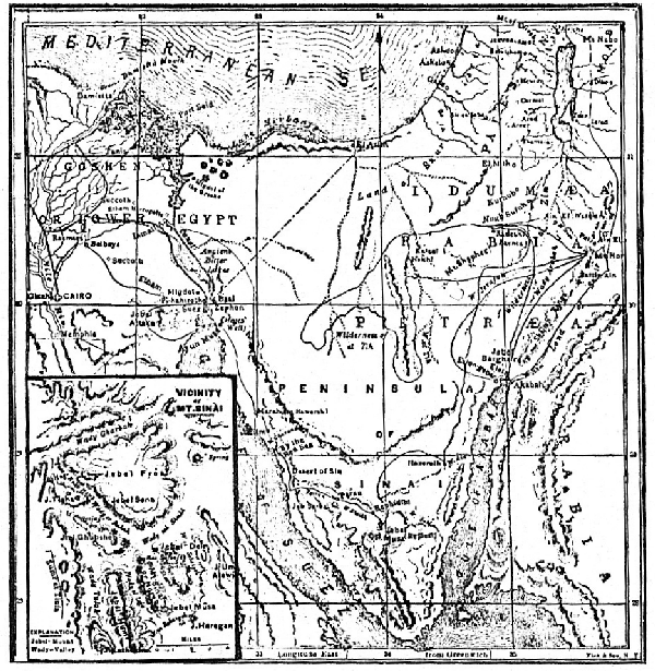
The journeys of Israel may be divided as follows: 1. Raamses to the Red Sea; 2. Red Sea to Sinai;
3. Sinai to Kadesh-Barnea; 4. Kadesh-Barnea westward, then southward, and finally eastward to Mt. Hor;
5. Mt. Hor southwest by Wady Jerafah to Ezion-geber; 6. Ezion-geber to Kadesh-Barnea; 7. Kadesh-Barnea
to Mt. Hor and Ezion-geber, preparatory to encompassing the land of Edom; 8. Ezion-geber by the
desert of Arabia and the land of Moab to the Jordan near Mt. Nebo.
|
THE WILDERNESS WANDERINGS.
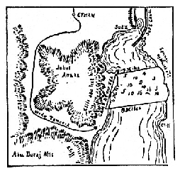
1. The first stage of the journey brought Israel to Etham near the head of the Red
Sea. From this point the obvious course was eastward across the upper end of the sea,
and thence down its eastern shore toward Sinai; but Israel was divinely led by a
pillar of cloud by day and fire by night, and this guide turned them back westward and
brought them around Jebel Attaka and through Wady Tawarik to the western shore
of the Red Sea. Here Israel found a beach almost as smooth as a floor and sloping
gently to the sea. This beach is two miles wide and nine miles long. Here Israel encamped.
God told Moses that they should come to this place, that Pharaoh might
think them entangled in the wilderness, and so be induced to pursue them. A glance
at the small map will show how the situation tempted Pharaoh. Israel was in a trap.
When Pharaoh filled Wady Tawarik with his chariots, there was apparently no escape
for Israel. The cliffs of Jebel Attaka to the north and west and those of the Abu
Duras Range to the south left Israel no choice but to cross seven miles of sea varying
from three to sixteen fathoms in depth in the channel. The cliffs of these mountains
are about 300 feet high, and the "strong east wind" would dash the water against their
bases, making escape impossible. But Israel's despair was God's opportunity. The
people under Moses crossed in safety, but the closing walls of water swallowed up
the Egyptians. [xxiv]
2. After refreshing themselves at the wells of Moses, of which there are seven,
the Israelites followed the shores of the sea, journeying in a southeasterly direction.
Twenty-five miles of travel brought them to the bitter waters of Marah (or bitterness),
Dow called Ain Hawarah (or fountain of destruction). The waters here are still
bitter. Five miles farther on they came upon Elim (or trees), with its twelve springs
 and seventy palm-trees. Just beyond Elim they encamped
by the shores of the Red Sea. Thus far
their second stage had been through the Wilderness
of Shur (or wall); they now entered the Wilderness of
Sin (or moon god). Here quails were sent, and manna
was first given. Through this wilderness they passed
some fifteen miles to the mouth of Wady Feiran, up
which they ascended and came to Rephidim. Here they
murmured for lack of water, and Moses was sent on
before with the elders of Israel to bring water from the
rock in Horeb. While the rear of the caravan was at
Rephidim, "faint and weary," the Amalekites fell upon
them. Next day Israel, under the leadership of Joshua,
and aided by the prayers of Moses, routed Amalek.
Thus Israel came to Sinai. Of Mt. Sinai (Ras Sufsafeh, i. e., "the head or peak of the
willow," so called from a large willow which grew in one of its crevices) and the surrounding
mountains, Porter thus writes: "The nakedness and desolation of these
mountains form one of the most striking characteristics. Their sharp, jagged tops,
their rugged sides, the wild clefts and glens which rend and separate them, are all bare
granite. The scarcity of water and the burning sun of a long summer, combined with
the nature of the rock and the extraordinary dryness of the atmosphere, account for
the absence of vegetation. This again causes a great scarcity of animal life. Beasts
and birds are almost as rare as human inhabitants. A silence as of death reigns
throughout the entire peninsula. The slightest sound--the call of the shepherd, or the
shout of the camel-driver--is heard to a great distance. The report of a gun, or the
fall of a fragment of rock from the mountain-side, reverberates from cliff to cliff, and
from valley to valley, like a thunder peal." "They were wrapt," says Stanley, "in a
silence which gave full effect to the morning and evening shout with which the encampment
rose and pitched, and still more to the 'thunders, and the voice exceeding
loud' on the top of Horeb." "Yet," says Porter, "though so naked, stern and desolate,
the mountains of Sinai are beautiful. The gorgeous coloring of the granite rock
makes up for the absence of foliage and vegetation." "The rocks," says Miss Martineau,
"were the most diversified I ever saw. I noted them on the spot as being black,
green, crimson, lilac, maroon, yellow, golden and white; and their form was that of a
whole host of cones. . . . The red granite mountains we were now in the midst of, are
massive and awful beyond any other mountains I ever saw. The sunset lights and the
morrow's dawn dressed them in splendor, but scarcely relieved their gloom." Of the
approach of Israel to Sinai, Stanley thus speaks: "Onward they went, and the
mountains closed around them, upward through the winding valley and under high
cliff, and over rugged pass, and through gigantic forms on which the marks of creation
even now seem fresh and powerful; and at last, through all the different valleys the
whole body of the people were assembled. On their right hand and on their left rose
long successions of lofty rocks, forming a vast avenue, like the approaches which they
had seen leading to the Egyptian temples between colossal figures of men and of gods.
At the end of this broad avenue, rising immediately out of the level plain on which
they were encamped, towered the massive cliffs of Sinai, like the huge altar of some
natural temple; encircled by peaks of every shape, and height, the natural pyramids of
the desert. In this sanctuary, secluded from all earthly things, raised high above even
the wilderness itself, arrived, as it must have seemed to them, at the very end of the
world--they waited for the revelation of God."
and seventy palm-trees. Just beyond Elim they encamped
by the shores of the Red Sea. Thus far
their second stage had been through the Wilderness
of Shur (or wall); they now entered the Wilderness of
Sin (or moon god). Here quails were sent, and manna
was first given. Through this wilderness they passed
some fifteen miles to the mouth of Wady Feiran, up
which they ascended and came to Rephidim. Here they
murmured for lack of water, and Moses was sent on
before with the elders of Israel to bring water from the
rock in Horeb. While the rear of the caravan was at
Rephidim, "faint and weary," the Amalekites fell upon
them. Next day Israel, under the leadership of Joshua,
and aided by the prayers of Moses, routed Amalek.
Thus Israel came to Sinai. Of Mt. Sinai (Ras Sufsafeh, i. e., "the head or peak of the
willow," so called from a large willow which grew in one of its crevices) and the surrounding
mountains, Porter thus writes: "The nakedness and desolation of these
mountains form one of the most striking characteristics. Their sharp, jagged tops,
their rugged sides, the wild clefts and glens which rend and separate them, are all bare
granite. The scarcity of water and the burning sun of a long summer, combined with
the nature of the rock and the extraordinary dryness of the atmosphere, account for
the absence of vegetation. This again causes a great scarcity of animal life. Beasts
and birds are almost as rare as human inhabitants. A silence as of death reigns
throughout the entire peninsula. The slightest sound--the call of the shepherd, or the
shout of the camel-driver--is heard to a great distance. The report of a gun, or the
fall of a fragment of rock from the mountain-side, reverberates from cliff to cliff, and
from valley to valley, like a thunder peal." "They were wrapt," says Stanley, "in a
silence which gave full effect to the morning and evening shout with which the encampment
rose and pitched, and still more to the 'thunders, and the voice exceeding
loud' on the top of Horeb." "Yet," says Porter, "though so naked, stern and desolate,
the mountains of Sinai are beautiful. The gorgeous coloring of the granite rock
makes up for the absence of foliage and vegetation." "The rocks," says Miss Martineau,
"were the most diversified I ever saw. I noted them on the spot as being black,
green, crimson, lilac, maroon, yellow, golden and white; and their form was that of a
whole host of cones. . . . The red granite mountains we were now in the midst of, are
massive and awful beyond any other mountains I ever saw. The sunset lights and the
morrow's dawn dressed them in splendor, but scarcely relieved their gloom." Of the
approach of Israel to Sinai, Stanley thus speaks: "Onward they went, and the
mountains closed around them, upward through the winding valley and under high
cliff, and over rugged pass, and through gigantic forms on which the marks of creation
even now seem fresh and powerful; and at last, through all the different valleys the
whole body of the people were assembled. On their right hand and on their left rose
long successions of lofty rocks, forming a vast avenue, like the approaches which they
had seen leading to the Egyptian temples between colossal figures of men and of gods.
At the end of this broad avenue, rising immediately out of the level plain on which
they were encamped, towered the massive cliffs of Sinai, like the huge altar of some
natural temple; encircled by peaks of every shape, and height, the natural pyramids of
the desert. In this sanctuary, secluded from all earthly things, raised high above even
the wilderness itself, arrived, as it must have seemed to them, at the very end of the
world--they waited for the revelation of God."
3. In front of Sinai, in the plain of Rahah (rest), the people encamped just a month
and a half after their departure from Raamses. Here they remained for one year, lacking
ten days. Among the prominent events of this stage we should note the descent of [xxv]
Jehovah upon Sinai; the sound of his voice speaking to the people; the giving of the
law; the worship of the golden calf; the construction of the tabernacle; the consecration
of the priests and setting apart of the Levites; the deaths of Nadab and Abihu;
the numbering of the people; the visit of Jethro, and the winning of Hobab.
4. For three days the people journeyed through a desolate land from Sinai toward
the wilderness of Paran. Their route lay through a dreary region of rugged hills and
bleak valleys, and inconsequence complaints were many. For this God sent fire among
the people till the prayer of Moses stayed it. But the mixed multitude were not to be
quieted; they almost broke out in open rebellion against Moses for lack of meat. God
again sent them quails, and the quails were followed by a disastrous plague. The caravan
then reached Hazeroth, a little spring eighteen hours distant from Sinai, where
Aaron and Miriam turned against Moses. From Hazeroth the route lay a little east of
north to the bluffs of Mt. Shepher. Here Israel probably turned eastward as the
nearest way to Kadesh-Barnea.
5. From Kadesh-Barnea the spies were sent to view the Promised Land, and the
behavior of Israel on their return led to the sentence of forty years' wandering (or
thirty-eight years, as the two years already spent in the wilderness were mercifully
counted). It is said that Israel abode many days at Kadesh. But the wilderness of
Paran and Kadesh are used interchangeably,, and so it is fair to suppose that the Kadesh
springs were used as headquarters, and that during the rainy seasons of many years
Israel pastured their flocks over the whole Wilderness of et Tih, as indicated on the
map, until they came to Mt. Hor. The Wilderness of et Tih (the wanderings) is so
called from time immemorial, because it is traditionally the place where many or most
of the thirty-eight years were spent. Of the wilderness of et Tih Porter says:
"No part of it is ever wholly destitute of vegetation; and it contains, notwithstanding
long centuries of neglect and desolation, many tracts of fertile soil, and rich pasture,
and thickets of tamarisk, juniper, and other dwarf trees and shrubs. In fact, it
is manifest that even at the present time the desert of et Tih is capable of supporting
immense flocks and herds, and a considerable population." In the torrent beds which
cut its surface, and in the blasted trunks of old trees, the traveler can see evidences
which prove that rainfall was once much more abundant, and that there were approaches
to forests in some parts. There are also extensive ruins of towns and cities,
which are substantial testimonials to the former prosperity and population of this
land. It is probable that the rebellion of Korah, Dathan and Abiram took place
during these years spent in Kadesh and et Tih.
6. Of the thirty-eight years of wandering little is said, and the journeys are not
clearly indicated. It is reasonable that they should be obscure, for the people were not
really journeying; they were merely spending time, and were probably scattered far
and wide over the scant pasture land of et Tih. But part of this time was also spent
in the Arabah, along the borders of Edom. Our sixth stage therefore finds them
wandering slowly down towards Ezion-geber, stopping to pasture their flocks wherever
grass was found and abiding until it was consumed. They would not travel as a businesslike,
compact caravan, but would be found skirting the foothills of Mt. Seir, and
stretching clear across the valley to the hills of the Wilderness of Zin, and thus they
descended to the head of the Gulf of Akabah.
7. From Ezion-geber Israel again turned northward and returned to Kadesh-Barnea.
This second visit, like the first, was prolonged, and probably covered several years.
Here Miriam died and was buried. The Kadesh springs were unequal to the demands
of so great a multitude, so Moses was again called on to bring water from the rock.
Here he and Aaron sinned in not glorifying God before the people, and were forbidden
to enter the Promised Land. Amalek and the Canaanites lay north of Kadesh, and it
would have been hard to enter Palestine by pressing directly northward. Besides, it
appears to have been God's design that Israel should enter by crossing the Jordan, that
a new significance might be given to the wilderness journey. Hence Israel sent messengers
to Edom, and sought to pass eastward through their land. They would probably
have journeyed from Kadesh to Ain el Weibeh and thence between the northern
end of the Shelrah Range and the southern end of the Dead Sea. But Edom refused
to permit this passage. [xxvi]
8. Consequently Israel turned eastward to the borders of Edom at Mt. Hor. Here
Aaron died at the command of God. From Mt. Hor they turned southward to Ezion-geber,
that they might turn the southern end of the Shelrah Range. It would have
been nearer had Israel passed directly from Kadesh-Barnea southward to Ezion-geber,
and the route would have been much more pleasant. The Arabah is the most desolate
and most trying portion of all the region west of the Shelrah Range. It is probable
that God led them down this sultry, blistering vale of Arabah that it might partly prepare
or educate them for the even more trying land which they would find east of the
Shelrah Range when they turned north from Ezion-geber. They needed such a preparation,
but were ever slow to learn.
9. Somewhere about Ezion-geber the people again murmured, and fiery serpents
were sent among them, causing Moses to erect the Brazen Serpent. Seeing the wasting
away of an entire generation save himself, Caleb and Joshua, it is probable that
Moses at this period wrote
the ninetieth Psalm.
The Desert of Arabia, by which they
passed to the confines of Moab, is a desert indeed. All their former journeyings in
wildernesses failed to prepare them for their experiences in crossing this howling waste.
"It is," says Porter, "a vast table-land, extending from the mountain range of Edom
eastward to the horizon, without tree or shrub, stream or fountain. The surface is
either bare rock, or white gravel mixed with flints, or drifting sand. The very Bedawin
dread the passage of this 'great and terrible wilderness.' For days together the
daring traveler who ventures to cross it must hasten onward, and should the supply of
water which he is obliged to carry fail, all hope is gone. Wallin, one of the very few
who traversed it, says: 'It is a tract the most desolate and sterile I ever saw. Its
irregular surface, instead of vegetation, covered with small stones, which, shining sometimes
in a dark swarthy, sometimes in a bright white color, reflect the rays of the sun
in a manner most injurious to the eyes.' Mr. Palgrave, who crossed it more recently,
almost in the track of Wallin, also gives a frightful account of it. It is far more desolate
and dreary and terrible than any region west of the Arabah." It was a dreary
waste for Israel; but the journey was made in safety, and at last the wanderings of
Israel were over. They now entered upon the period of conquest which forms another
chapter in their history. [xxvii]
[Standard Eclectic Commentary for 1902, pp. xxiv-xxvii.]
ABOUT THE ELECTRONIC EDITION
The electronic version of Philip Y. Pendleton's "The Wilderness
Wanderings" has been produced from a copy of the Standard Eclectic
Commentary (Cincinnati, OH: Standard Publishing Company, 1901) held
by the Disciples of Christ Historical Society.
Pagination in the electronic version has been represented by placing
the page number in brackets following the last complete word on the
printed page.
Inconsistencies in spelling, capitalization, punctuation, and
typography have been retained; however, corrections have been offered
for misspellings and other accidental corruptions.
Emendations are as follows:
            Printed Text [ Electronic Text
 -----------------------------------------------------------------------
 p. 25:     Repidim, [ Rephidim,
 p. 27:     an other [ another
Addenda and corrigenda are earnestly solicited.
Ernie Stefanik
373 Wilson Street
Derry, PA 15627-9770
stefanik@westol.com
Created 3 May 1999.
|
Philip Y. Pendleton
|
The Wilderness Wanderings (1901)
|