 |
| JOPPA. |
|
[Table of Contents] [Previous] [Next] |
J. W. McGarvey Lands of the Bible (1881) |
C H A P T E R I V.
PLACES IN THE MARITIME PLAIN.
§ I.
IN THE LAND OF THE PHILIS'TINES.
THE places mentioned in the last section of Chapter III. are along the border-land between the ancient kingdom of Judah and the land of the Philis'tines. We have seen that the western view from Beth'-shemesh lies along the broad and beautiful floor of the Valley of Sorek, which runs out into the Philis'tine Plain (pages 262, 263). The western course of the Valley of Elah, after its curve a mile or two north of Bêt Nettîf', runs parallel with the Valley of Sorek, and lies about three miles south of it, with high and rocky hills between. On the southern side of the former, just before it spreads out into the plain, rises the rounded and isolated hill called Tell Sâ'fieh, which Lieutenant Conder has identified with Gath. Its summit, which is about 500 feet above the bed of the valley, is crowned with a small village built among ruins, while a Mohammedan wely occupies the very highest point and is a conspicuous object in the landscape for many miles around. There is now but little, if any, doubt of the correctness of this identification. The site, rendering a walled city built on it almost impregnable, is in every way well suited to the history and character of this stronghold of the Philistines. It was the border city toward Israel, and it very naturally bore the brunt of the wars between [264] the two nations. From its summit almost the entire Philis'tine Plain is in view, and much of the Plain of Sha'ron. The plain stretches away to the west about 15 miles, where the horizon is bounded by the vapor, which, like a gray cloud, ever hangs over the Mediterranean when seen at a distance. Almost in the horizon, a little west of north, is the present miserable village of 'Akir', the ancient Ekron.
Turning the eye farther south, we see a large number of villages and towns, some perched on high conical hills rising out of the plain, and some on smooth ridges which impart a waving appearance to the surface. Most of them are surrounded by groves of olive-trees. Fields of grain everywhere checker the plain with yellow or green according to the season, while the dark shade of the freshly-plowed fields adds variety to the coloring. The sites of Ashdod, Askelon, and Gaza are in view, or so nearly so that one standing on high ground in the immediate vicinity of each could see a signal-fire on the hill of Gath. The king of Gath could summon the entire nation to arms by such a signal at night with rapidity equal to that of the electric telegraph. All of the villages and towns in view are the modern representatives of the villages and unwalled towns which were once the dependencies of the five great cities of the Philis'tines.
The modern Gaza (el Ghuzzeh), the most southern of the five ancient cities, is about 35 miles by the nearest route west of Hebron, and about 50 southwest of Jerusalem. It has now a population variously estimated at from 15,000 to 18,000.1 When Dr. Robinson saw it in 1838, he put the population at from 15,000 to 16,000, showing that there has been no material change in the last forty years. With the exception of 300 or 400 Christians of the Greek Church, the people are all Mohammedans. It has a mission school of the Church of England. Most of its houses are built of sun-dried bricks, with roofs of earth, and they present an unattractive appearance. The principal mosque, an old church, is well built of stone, with a handsome front and a minaret of considerable height. There are a few other houses of stone, but all have a dilapidated appearance. The bazaars are mean and dirty, and the narrow, unpaved streets are deep in dust and sand. But while the city itself is unattractive, the broad valley in the midst of which it stands is quite the reverse. This valley runs north and south, and for about five miles north of the city and a mile or more south it is thickly set with olive-trees and other vegetation. Shallow wells afford an abundance of water for all purposes. The valley is separated from the [265] plain to the east of it by a sand-ridge, and a similar ridge of perfectly bare sand extends from its western side to the seashore, a distance of about two miles. Between the city and the seashore are evident remains of an ancient city, especially on the slope toward the shore. The sand which the waves are perpetually forming as they beat upon the soft sandstone of the shore, and which the wind is driving inland, has deeply covered the entire surface; but here and there a part of a ruin has kept itself in view by causing an eddy in the wind which whirls the sand away from it. Captain Warren says, "Wherever the ground has been turned over, hewn stones, fragments of wall, and innumerable pieces of pottery, the surest signs of an ancient city, have been found."2 This fact leaves little room for doubt that ancient Gaza stood nearer the sea and that it was a far more substantial city than the present Gaza is or ever has been. It was a walled city, and it existed in the days of Abraham. About a mile southeast of the city is a hill 200 or 300 feet high, called Mûntâr', which is covered with old tombs, and from whose top is obtained a magnificent view of the adjacent country. To the east the eye ranges over broad and fertile plains, terminated by the purple hills of Judah. Toward the south, beyond the cultivated district of a few miles, is seen the smooth surface of the desert, while toward the west, beyond a yellow strip of sand, roll the blue waves of the Mediterranean. A telegraph line now reaches Gaza, connecting it with Jerusalem, Joppa, Damascus, and Beirût. It belongs to the Turkish government; and is used chiefly for military purposes.
That portion of the Philis'tine Plain lying between Gaza and the mountains of the east of it, together with all the grain and grazing-lands between that line and the desert to the south, is occupied by Bed'awin Ar'abs, who cultivate extensive fields of grain and pasture large herds of camels, cattle, and sheep and goats, and a considerable number of horses. Among their horses are occasionally seen some handsome and well-kept animals. Their encampment are scattered chiefly along the winding course of Wâdy Sharîa, a perennial stream which rises to the northeast and enters the sea south of Gaza. It is crossed in coming to Gaza from Beer'sheba, and by the most direct route from Hebron. The road from Bêt Jibrîn' to Gaza passes near the dividing-line between villages which abound in the north, and the houseless plain of the Bed'awin on the south. When within about 15 miles of Gaza, the road passes an elevation on its right called Tell Aj'lan, supposed to be [266] the site of the ancient Eglon, an important city in the days of Joshua.3 Heaps of stones where buildings once stood are scattered over a considerable area, but they are chiefly small stones of irregular shape, which were laid, like similar stones in modern buildings, in a large quantity of mortar. About three miles farther toward Gaza, on another eminence to the right of the road, is Um Lâ'kis, the ancient Lachish,4 of which nothing is left but stone-heaps and rock-cut cisterns. There is no doubt that the ancient cities on this rich plain were built, like the modern villages, chiefly of sun-dried bricks, and this in part accounts for the meagreness of the ruins which they have left. About two miles southwest of Lachish the road crosses Wâdy el Hâsi, a perennial stream, which Robinson supposes to have been the "certain water" in which the eunuch was baptized by Philip.5
About twelve miles north of Gaza, and immediately on the seacoast, is Askalân', the ancient Askelon, reached from Gaza by a ride along the beach or a few miles inland. About half-way between the two places the road crosses Wâdy Esnêd, a beautiful stream of water, whose valley, as far as the eye can follow it, is covered with verdure. At Askelon are seen the best-preserved and most interesting ruins in all the Philis'tine country. The walls of the city on the land side were built on a semicircular ridge curving inland, with the shore as the diameter of the circle. The surface slopes from the ridge toward the shore, and the sea-wall was built on a cliff of sandstone 30 or 40 feet high. The semicircle is about 1¾ miles around. The wall next to the sea is still standing in broken masses, while immense blocks of it, weighing hundreds of tons each, have fallen upon the rocks and into the edge of the water below. This fall has been caused, in part at least, by the wash of the waves undermining the sandstone foundation. All round the wall, but especially on the sea side, long granite columns were built crosswise into the walls to strengthen them. In many places on the seaward side a portion of the thickness of the wall has fallen away, leaving these columns, like large pieces of artillery, projecting five or six feet from the front of the remaining wall, and pointing toward the sea. The material of the wall is chiefly a dark-brown sandstone, in small pieces. The cement in which they were laid is harder than the rock itself, and still holds together the great fallen masses of stones. Nearly all of the semicircular part of the wall is still standing in a broken condition, but it is nearly covered by the sand-ridge which is gradually forming on both its inner and outer sides. [267] In some places, however, the wall still stands from 20 to 30 feet high above the sand. In the interior of the semicircle, as in the bottom of a very deep saucer with one side broken away, are some very rich and beautiful gardens set with vines, figs, pomegranates, palms, and garden vegetables, and supplied with numerous wells of excellent water and plastered tanks to hold water for irrigation. But there is not a human habitation within the walls, these gardens being owned and cultivated by the inhabitants of Jô'ra, a village a mile distant to the northeast.
The Bible history of Askelon is unimportant. Hither Samson came from Timnath, 24 miles, to get the 30 shirts.6 But it figured more conspicuously than any other Philistine city during the wars of the crusaders, and the present ruined walls are doubtless those built by Richard Cœur de Lion. The granite columns, however, which he used so freely to strengthen his sandstone walls, were the remains of the then ancient city, and had probably adorned some of the heathen temples of the Philis'tines. They speak of a splendor far exceeding that of the crusading period. The city has been in ruins ever since the year 1270, when its fortifications were dismantled by order of the Egyptian Sultan Bibars.7 The utter desolation of this city and of the original Gaza presents a striking fulfillment of prophecy, for the prophet Zephaniah said of them, 600 years before Christ, "Gaza shall be forsaken, and Askelon shall be a desolation."8
About two miles east of Askelon, and a little north, is the large and flourishing village of Mejdel, probably the Migdol-gad of Joshua (xv. 37), one of the cities given to Judah, but never captured by that tribe. It is chiefly built of sun-dried brick, but partly of soft sandstone. The present inhabitants are better dressed, appear more intelligent, and make greater efforts to ornament the fronts of their houses by the use of a wash of various colors, than any other community in this plain. Splendid fields of grain surround the town in every direction, and olive-groves extend for miles to the north and south. Many acres are cultivated in cucumbers and tomatoes, and there are a few orange-orchards. The moisture of the subsoil is sufficient for all these, except the oranges, and shallow wells, which abound everywhere, furnish abundance of water for the irrigation of these. The population numbers about 1500, nearly all Mohammedans.
About eight miles north of Migdol, and about nine northeast of Askelon, is Esdûd, the Philis'tine Ashdod, called in the New [268] Testament Azotus.9 It was here that the ark of the covenant was placed in the temple of Dagon when captured by the Philis'tines,10 and it was here that Philip was first found at work for Christ after the baptism of the eunuch. It lies about three miles from the seacoast, and it once possessed a seaport, which has now disappeared. It is a very small village, but, like all the modern villages on ancient sites, it contains fragments of ancient masonry and broken columns in its walls. It is surrounded with olive-trees.
Going north from Ashdod, in about nine miles we come to Jabneh or Jabneel, now called Yebna. It was on the northern line of the territory originally given to Judah,11 but it was not taken until David's conquest of the Philis'tines, and even after this it became once more independent, and its walls were finally broken down by Uzziah.12 It was an important town after the destruction of Jerusalem, and during the wars of the crusades. Some four or five miles east of it is Akîr', the ancient Ekron. This is a miserable village of huts made of sun-dried bricks, with scarcely a vestige of antiquity visible about it. It is about 14 miles from Joppa, a little east of south.
We have now named all the principal cities along the Philis'tine coast, and have seen that from Gaza to Askelon is 12 miles, thence to Ashdod 9 miles, thence to Jabneh (on the parallel of Ekron) 9 miles, and thence to Joppa 14 miles. The entire coast, therefore, from Gaza to Joppa, measured by the line of land-travel, is 44 miles. Four of the capital cities of ancient Philistia lie along the coast, Askelon immediately on it, Gaza and Ashdod each about three miles from it, and Ekron about five miles from it; while the distance from Gaza to Ekron is about 30 miles. Gath, as we have seen, was on the opposite side of the plain, adjoining the border of the hills of Judah, and about 12 miles a little east of south from Ekron.
§ II.
IN THE PLAIN OF SHARON.
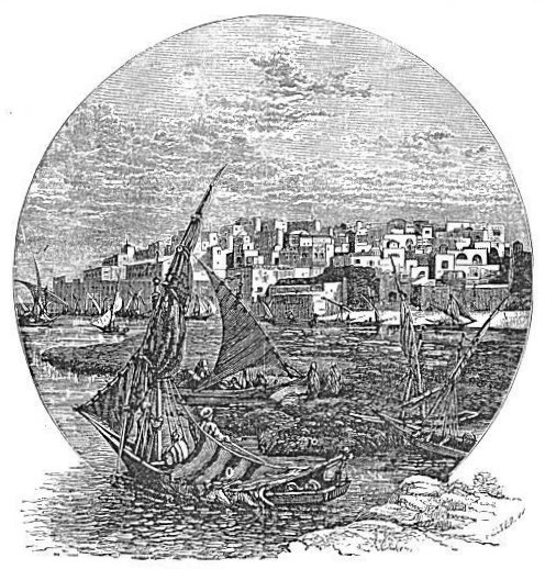
The most important and the most ancient city in the Plain of Sha'ron is Joppa, now called Yâfa by its native inhabitants. It is known chiefly to the Bible-reader as the place at which Hiram landed the cedar beams for Solomon's temple, at which Jonah embarked when fleeing to Tarshish, and at which Peter raised Tabitha from the dead, and [269] afterward, on the roof of the house of Simon the tanner, saw the vision of the great sheet let down from heaven.13 It seems not to have been a place of much importance during the Biblical period, and during the crusades it was almost depopulated; but in the year 1799, when Palestine was invaded by the French army under Napoleon, it was a walled town. Its population and its commercial importance have greatly increased within the last 25 years, so that it has outgrown its walls and torn them down. The present population of the city and its suburbs is estimated at from 15,000 to 20,000, mostly Mohammedans, but including from 2000 to 3000 Jews, from 400 to 500 Europeans, and a small number of Syrian Christians.14 A German colony which settled there in 1868 numbers about 300 souls, and they cultivate about 1000 acres of land northeast of the town where their village is situated. Their houses, built and furnished in European style, present a pleasing contrast to those of the natives. They keep a good school for the education of their children in various languages. They belong to a sect called the Temple Church, one of whose tenets is that it is the duty of Christians to settle in Palestine and restore it to prosperity. There are four convents in the city, Greek, Latin, Armenian, and Coptic; and besides the German school, there are two Protestant missionary schools, one of them kept by an American lady (Miss Hay) in the only "frame" house in Palestine, or perhaps in Western Asia. In addition to the German settlement, there has been recently established a Jewish settlement southeast of the town, with a large tenement-house and 300 acres in cultivation. The city contains two hotels, one kept by a native Christian and the other by a German,--the latter by far the better of the two. The house of Tabitha and that of Simon the tanner are both shown to the traveler, but he knows, of course, that they are not the originals.
The city is situated on a rock which rises about 100 feet above the level of the sea. The surface both to the north and the south lies at a lower level, and the seashore recedes a little on both sides, leaving the city on a promontory projecting slightly into the sea. The streets which ascend the hill are so steep that in many places they have steps cut in the rock; but the principal street runs along the foot of the hill, near the water's edge, from the front around the northern side. The finest view of the city is from the sea. There is no harbor, and ships [270] anchor about a mile out at sea. From this position the houses seem to rise from the water's edge, one above another, to the summit of the rounded hill, and to lie massed together in utter confusion. The dull gray color of the rock of which they are built, unrelieved by either
|
| JOPPA. |
white or colored paint or by any ornamental style of architecture, causes the town to present an unattractive appearance. The above cut gives the view from the southwest.
To the south of the city are seen a few detached buildings and gardens, then a naked sand-ridge, and beyond all, in the distance, the dark ridge of the Judean hills. To the north, beyond a low shore of yellow sand, are green fields and orchards. In passing from the ship to the shore, the rude boats of the natives are compelled to go through [271] a narrow gap between brown rocks which rise a little above the surface of the water and make the landing very dangerous in rough weather. Boats are sometimes capsized here, and occasionally passengers are drowned. In stormy weather ships do not cast anchor at all, but take their passengers on to Beirût'.
The lands immediately around Joppa are now the most carefully and profitably cultivated of all in Palestine. There are 400 orange-gardens of from 2½ to 6 acres each, amounting to probably 1300 or 1400 acres of this delightful fruit, and the oranges are in some respects the finest in the world. They are entirely seedless; they have no tough membrane between their compartments; they have a thick juice with a delicious flavor; and they are of immense size, many measuring about 12 inches in circumference. Between 200,000 and 300,000 bushels of them are annually shipped to the ports of the Mediterranean and to the towns and villages of the interior.15 Besides oranges, lemons, apricots, citrons, grapes, and pomegranates are also cultivated in considerable quantities. All these fruit-gardens are irrigated by water drawn from wells which are only from 20 to 30 feet deep. The water is raised by a horse-power which turns a wheel, around whose rim is an endless belt strung with earthen jars. As the jars, after passing under the water and being filled, reach the top of the wheel, they empty their water into a trough at one side, whence it is conveyed through a spout into the irrigating channel. The supply of water is practically inexhaustible. It is the surplus of the winter rainfall on the mountains and plains of the interior slowly percolating along the surface of the underlying rock toward the sea.
The present route of travel from Joppa to Jerusalem is by a turnpike-road running almost due southeast across the Plain of Sha'ron, and then more nearly east up the beds of wâdies and across high ridges and deep valleys to Jerusalem. The distance is 38 miles. The road was built in the year 1872 by the Turkish authorities, and is a very good one until it reaches the hills; but in many places beyond this it is much broken by winter torrents. At a distance of about 12 miles from Joppa on this road is the town of Ramleh. It is not named in the Scriptures, but has obtained its importance since the Mohammedan invasion. It is a well-built town of stone houses, containing a population of about 3000 souls, about one-third of whom are Greek Christians. It contains a Greek and also a Latin monastery, both of which furnish lodgings to travelers. It has also a small hotel, kept by a German [272] who belongs to the colony at Joppa. Travelers frequently go to this place on their way from Joppa to Jerusalem in an afternoon, in order that their journey the next day may be a moderate days ride. It is better, however, to go to Howard's hotel at Latrûn', which divides the distance nearly equally.
The most notable object at Ramleh is the ruin of an old mosque at the western end of the town. Its outer walls are still traceable,
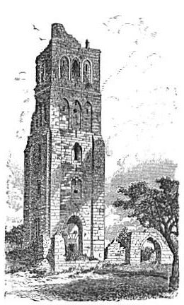 |
| TOWER OF THE FORTY. |
After passing about three miles beyond Ramleh the road crosses the first hill on its way, and nearly due south of this hill is a detached [273] eminence called Tell el Jezer, identified as Gezer, a city in the land allotted to Ephraim in the days of Joshua.16 It was taken from the Canaanites long afterwards by Pharaoh and given to Solomon, who fortified it.17 It commanded one of the roads leading from the plain up to Jerusalem, and it was therefore one of the defenses of Solomon's capital. Some interesting ruins are found on the site, some rock-cut tombs are on the slopes of the hill, and a fine spring breaks out at its eastern foot.
After crossing a few low hills the road enters the mountains near Latrûn', to which point we have traced it from Jerusalem in a former chapter. (See page 244.) A short distance north of Latrûn' is the village of Amwâs' (Emmaus), but not the Emmaus mentioned in the 24th chapter of Luke. True, it has been so regarded in tradition, and even Lieutenant Conder so regards it, notwithstanding the objection that it is 160 furlongs from Jerusalem, while the true Emmaus was only 60 furlongs distant.18 He meets this objection by supposing that the reading of the Sinaitic manuscript is correct, which has 160 furlongs; but this reading must be erroneous, from the fact that the two men of the narrative could not have walked such a distance (20 miles) back to Jerusalem between the late afternoon hour at which Jesus left them and the early hour of the night at which they reported to the eleven.19 Another site, northeast of this, on the road from Jerusalem to Lydda, called El Kubei'beh, which a very old tradition identifies with Emmaus, seems better entitled to the distinction. It is due west from Neby Sam'wil, and according to the measurement of Mr. Schick, a German architect resident in Jerusalem, it is just 62½ furlongs from the city.20 The village contains many ruins, and its situation is beautiful.
About 2½ miles north of Ramleh, and 11 miles southeast of Joppa, is Lud, the Lydda of the New Testament, where Peter raised E'neas from a bed of sickness, and whence he was called to Joppa after the death of Tab'itha.21 It is a well-built town, and stands in the midst of a grove of olives extending about a mile northward, and reaching southward to Ramleh and beyond. This is probably the largest olive-grove in the Plain of Sha'ron. It is about five miles long from north to south, and from one to two miles wide. Intermingled with the olives are a few fig- and mulberry-trees. The chief object of antiquity in the place is the ruined church of St. George, a portion of which has [274] recently been repaired. It belongs to the Greeks, and it is said to be built over the tomb of St. George, the patron saint of England, who was born, died, and was buried here.
There is a road leading from Joppa up the seacoast, though generally a mile or more away from the water's edge, along the entire length of the Plain of Sha'ron. About 3½ miles from Joppa this road crosses Nahr el Aujeh, the river Aujeh, near its mouth. It is the largest stream, next to Crocodile River, on this plain. It rises some 9 or 10 miles eastward, at the base of the hill on which stood the town of Antip'atris, mentioned in the account of Paul's journey as a prisoner from Jerusalem to Cæsarea.22 The place is now called Ràs el Ain (the Promontory of the Spring), from the immense volume of water which rises out of the ground under its northern and western sides and forms the river Aujeh. The top of the hill is crowned with the massive ruins of a large castle built by the crusaders, and is known to represent Antip'atris, because the latter is said by Josephus to be in the plain, close to the hills, with a river encompassing it, and this is the only ruin answering to the description. It is 11½ miles from Lydda on the way to Cæsarea, and 30½ from the latter place. From this place, says Conder, "the stream flows rapidly away westward, burrowing between deep banks, and rolling to the sea, a yellow, turbid, sandy volume of water, unfordable in winter, and never dry, even in summer."23
Not far from Antip'atris, in the border of the hill country, is Tibneh, which is with some probability identified with Timnath-Serah, the inheritance and burial place of Joshua.24
The distance from Joppa to Cæsarea is about 30 miles by the road leading near the coast, but the principal route of travel in ancient times from Cæsarea southward was farther inland, and led to Lydda, leaving Joppa to the right. In this distance, besides the river Aujeh, the road crosses three other streams, the Fâl'ik, the Iskandaria, and the Mefjir. These are smaller streams than the Aujeh, and are not at all seasons able to push their way through the ridge of sand which is constantly increasing along the shore. Their obstructed waters form deep pools and marshes on the edge of the plain, as is the case also along the Philis'tine coast between Joppa and Gaza. A little artificial help would secure their passage to the sea and rescue many acres of fine land from inundation, and at the same time it would render the plain far less malarious than it must be in its present condition. [275]
Cæsarea, which still retains its original name in the corrupted form of Kaysarî'yeh, was not one of the original Hebrew cities, but was built by Herod the Great, and its completion was celebrated in the year 13 B. C., twelve years after its foundations were laid. Josephus gives a detailed account of the construction of the city, and especially of the harbor, which was altogether artificial.25 From the beginning of its history it was the principal seaport of Palestine, and it was made by the Roman governors of Judea the political capital of the nation. It will ever be a place of interest in the minds of Christians on account of the baptism there of the first Gentile converts, the incidents connected with Paul's last journey to Jerusalem, and the two years' imprisonment of Paul under Felix and Festus.26 It is also noted as the home of Eusebius, the earliest of ecclesiastical historians. It figured conspicuously in the wars of the crusades, being frequently taken and lost by the contending parties. The last attempt to restore its fortifications was made by Louis IX. of France in 1251, and it was destroyed in 1265. Since then its harbor, the breakwater of which, according to Josephus, was made by sinking rocks 50 feet long and 18 wide into water 20 fathoms deep, has been filled up till it is too shallow for the smallest ships, and the sandstone walls and towers in reach of the waves have to a great extent been crumbled into sand and blown inland by the winds. The wall of the city still stands, from 20 to 30 feet above the ground in a few places, while the walls of the moat which surrounds it on every side, except that toward the sea, are in a perfect state of preservation. The moat is 30 or 40 feet across at the top and about 20 feet deep. The space inclosed by the walls is a rectangle, 540 yards long from north to south and 350 wide from east to west. The walls are about six feet thick, and are strengthened by many buttresses and square towers. The gate in the south end is preserved, and through it all visitors enter. Near by it on the inside is a well of never-failing water, and hither flocks and herds are daily led from the immediate vicinity to be watered. There is also near this gate, and fronting the sea, the ruins of a large and magnificent church, the entire outline of which is distinctly traceable, and much of its wall is still standing from 15 to 20 feet high. The remainder of the surface within the walls is a confused mass of rubbish from the crumbled limestone of ancient buildings. Josephus told the truth when he said that Herod built the city of "white stone," "of materials brought from other places, and at very great expense;" for the stone chiefly used is [276] limestone, and there is none to be found nearer than the mountains, 9 or 10 miles distant across the Plain of Sha'ron. On the mole built for the harbor, which extends out into the sea from the southern end of the city, stand the ruins of an immense castle very massively built, and even now rising 40 or 50 feet into the air. The author counted 75 granite columns which were built crosswise into the walls of this castle, all of which are now exposed. Among them are several of red granite, and of immense size. Over against this mole to the north stood another structure of a similar character, which has crumbled away. Its columns have fallen into the shallow water, where they lie, about 70 or 80 in number, like a sunken raft of saw-logs. Nothing can exceed the desolation that broods over this spot, once so full of life and animation, and so prolific of historical events. The continual roar of the waves, which even in the mildest breeze are ever breaking against Herod's sunken masses of rock, tends to heighten the impression, and when one passes out of the city on any side, it is intensified by observing that along the surface of the ground, north, south, and east, are uninterrupted traces of ancient dwellings, long since gone to destruction. Leaving the city by the road running northward, the last monument of its glory and of its ruin that comes into view is the wall which once supported, on a long series of arches, an aqueduct that brought a stream of water into the city from Crocodile River, three or four miles distant. The city once extended far beyond its present walls.
About 2½ miles north of Cæsarea the coast-road crosses the mouth of Nahr Zerka(Blue River), called Crocodile River by ancient writers, because crocodiles were then, as now, found in its waters. That they are still found is attested by various writers.27 The sand near the sea-coast so obstructs the passage of this river into the sea that its depth and width at the ford near its mouth are much less than farther out from the shore. When crossed by the writer in May, 1879, it was about sixty feet wide and three feet deep. The horse of our dragoman got mired in the sand, broke his girt, and threw saddle and rider into the water. About a mile above the mouth of the river, where it once broke through a low rocky ridge, the opening through the ridge has been dammed by a wall 20 feet thick, and the water above it is elevated 25 feet. The wall is 230 yards long, and the road passes over it as on a bridge. When the place was visited by Thomson there were eight or ten mills in motion just below this dam, propelled by the [277] water falling directly upon their wheels, and he says there was room for twenty. The dam causes a great marsh in the plain above, rendering thousands of acres of rich land untillable.28
About four miles north of the Zerka or Crocodile River the road crosses another perennial stream called the Nahr Kerâ'jeh, which waters and makes verdant a considerable belt across the plain, and about a mile north of it is the village of Tantu'ra, immediately on the sea-shore. It occupies a low promontory which juts out into the sea far enough to form, south of it, a harbor for the small sail-boats which trade along the coast. Back of the village, toward the hills and among them, some timber is found, which is cut and brought to this place to be shipped to Beirût' for manufacturing purposes. North of the town is a little bay, and north of it another promontory crowned with the ruin of a very massive castle. A part of the wall of this castle is still standing, about 50 feet high, and it is a very conspicuous landmark, seen for many miles up and down the coast. Above the castle, and reaching out from the shore, are the ruins of an ancient city almost as extensive as those at Cæsarea, and scattered among them are many granite columns. These are the ruins of the ancient city of Dor, which was occupied by Canaanites in the days of Joshua, and which held out against the attack of the tribe of Manasseh, to whom it was allotted.29 There are several small islands of naked sandstone a short distance from the shore, and these may be the remains of a natural breakwater which once formed a harbor for vessels of moderate size.
Scarcely more than six miles north of Dor, and 15 from Cæsarea, are the ruins of Athlît. Here a cape projects nearly a mile into the sea, terminating in a rocky promontory. On this promontory is a large castle with massive walls built of very large stones, and evidently once an almost impregnable fortress. A portion still stands, about 80 feet high, in an almost perfect state of preservation. A deep moat, still distinctly traceable, cuts it off from the main part of the cape. The remainder of the cape was occupied by the city, and the city wall crossed the neck of the cape. The latter is still traceable, and its moat still contains water for a considerable distance.
From this point to the northern terminus of the Plain of Sha'ron is some 8 or 9 miles, along a constantly-narrowing plain between the sea and the gradually approaching side of Mount Carmel. The plain is most of the way divided into two narrow strips by a narrow ridge of rock running along the middle of it parallel with the shore. The road, [278] on leaving the vicinity of Athlît, passes through this ridge by a narrow artificial cut, and continues on the eastern side until it reaches the narrow bench around the sea end of Mount Carmel, where it curves to the northern side of that mountain and reaches Hai'fa.
[LOB 264-279]
|
[Table of Contents] [Previous] [Next] |
J. W. McGarvey Lands of the Bible (1881) |
|
Send Addenda, Corrigenda, and Sententiae to
the editor |