 |
| THE HAR'AM AT HEBRON. |
|
[Table of Contents] [Previous] [Next] |
J. W. McGarvey Lands of the Bible (1881) |
C H A P T E R I I I.
PLACES WITH HEBRON AS A CENTRE.
§ I.
HEBRON AND ITS SUBURBS.
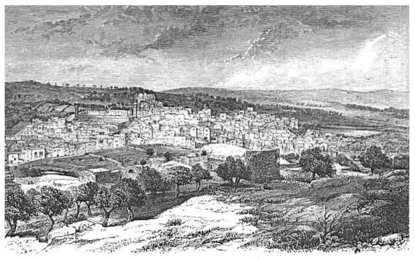
HEBRON is twenty miles south of Jerusalem, and it is one of the oldest cities in Western Asia. The author of Genesis conveyed an idea of its antiquity to his own generation by telling them that it was built seven years before Zoan in Egypt. Between the time of Abraham and that of the Judges its name was changed to Kirjath-ar'ba, but the old name was restored by Caleb,1 and it has been perpetuated till the present day, the Ar'abs calling it El Kahlîl (the friend), which is but their version of Hebron (friendship). It has an important history running through the chief part of the Old Testament, but it is not once mentioned in the New Testament. Its present population is between [247] 8000 and 10,000, of whom 500 are Jews.2 It is stretched along the southwestern slope of a ridge, to whose base it reaches, but whose summit rises about 200 feet above the upper edge of the city. It is nearly half a mile long and a quarter of a mile wide. It carries on a lively trade with the surrounding villagers and the Bed'awin of the adjacent deserts, and the intercourse between it and Jerusalem is considerable. It does a large business in wool and camel's hair and in the
|
| THE HAR'AM AT HEBRON. |
manufacture of leather buckets. It has also a small glass-factory devoted chiefly to the making of colored rings of common glass, which are used by the women of the country as bracelets.
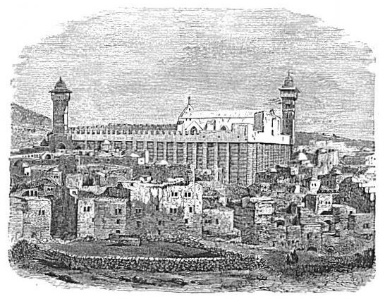
The centre of attraction at Hebron is the har'am, or sacred inclosure, which is supposed to include the Cave of Macpe'lah. It is at the upper edge of the town, and near its southern end. Its wall is built of beveled stones, like those in the oldest part of the temple-wall in Jerusalem, and this has led many to suppose that it was built by [248]
 |
| HEBRON. |
| Page 248. |
Solomon. It is generally agreed that it is not of later date than the reign of Herod the Great. Josephus speaks of it (War, 4, 9, 7), and, as he does not attribute it to Herod, it must run farther back, and most likely to Solomon. The old wall is from 50 to 60 feet high, according to the slope of the ground, and it is strengthened by square pilasters at regular intervals. A new wall, running up some 10 or 15 feet higher, has been built by the Moslem on top of the old one. The space inclosed by this wall is a quadrangle 112 feet wide and 198 feet long, the long way being from northwest to southeast. A broad bench was cut on the hillside to give it room. Houses are built against the side toward the town, a flight of broad steps ascends on the southeast side to the level of a portico which runs across the northeastern side, and in this side, which is toward the hill, is the entrance. Under the escort of the shêikh of the town a Christian is allowed to ascend the steps, but he must go no farther; and when he is approaching even this near, the women and boys of the town are heaping bitter curses on his head. The Prince of Wales was the first person of Christian faith permitted to enter this inclosure since the Moslem have had possession of it. This occurred in 1862, and Dean Stanley, who accompanied him as one of his suite, gives an interesting account of the visit at the end of the first volume of his lectures on the Jewish Church. The same privilege was accorded the Marquis of Bute in 1866, and the Crown-Prince of Prussia in 1869. About one-third of the interior space is occupied by a mosque, once a Christian church. Cenotaphs of Abraham and Sarah, Isaac and Rebecca, Jacob and Leah, occupy spots, some within the mosque and some outside of it, and one also represents Joseph, who, according to a Moslem tradition, was disinterred after being buried at She'chem, and removed to this place. The distinguished visitors just named were allowed to examine these objects, but were not permitted to descend into the cavern beneath the floor, which is the real resting-place of the dead; nor, indeed, were they allowed to see the door by which admission is gained. They saw only a circular hole into the rock, eight inches in diameter, which is supposed to pass through the roof of the cave. The Moslem guardians of the mosque say that even they dare not enter the cavern lest they incur the displeasure of the holy dead and be smitten with a curse. They relate that about 2500 years ago a servant of a great king entered there; that he went in sound in mind and corpulent in person, but that he came out blind, deaf, withered, and crippled. A similar feeling of superstitious dread attaches to all such shrines in the minds of the Moslem, and doubtless this is one cause of their persistent opposition against the entrance of [249] Christians into their holy places. This sanctuary, however, is the only one in Palestine yet inaccessible to Christians, and there can be no doubt that advancing light and the free use of money will yet open even it to the inspection of enlightened travelers. It is quite possible that the body of Jacob is yet there in a good state of preservation, seeing that it was embalmed in the best style of Egyptian art; but it is scarcely possible that the bones of any of the other occupants of the cave are yet preserved.
Next to the har'âm in interest and antiquity are the two pools of Hebron. The larger of these is in the lower part of the town, and a person entering the town from the west passes it on his right as he goes directly toward the har'âm. Its wall is of very ancient masonry, and is built up about three feet above the street. It is 142 feet square and about 20 feet deep, with a flight of stone steps descending in one corner. When seen by the author, boys and men were swimming in it, entering from the steps, while men and women at the corner diagonally opposite were drawing water to fill their skin-bottles and to water their stock. This, in all probability, is the pool near which David hung up the feet and hands of the men who assassinated Ishbosheth.3 The other pool is toward the northwestern end of the town, and is much smaller, though it is constructed in the same manner and bears the same marks of antiquity. It is 74 feet long, 54 feet wide, and 21 feet deep. Both of the pools appear to be supplied by rainwater, though the bed of the valley, along which a stream of water flows in winter, passes by the western side of each.
It is supposed by some writers that Hebron does not now occupy its original site. This opinion is based upon the fact that the Cave of Macpe'lah, which is now in the upper edge of the city, was originally "in the end of the field" of Ephron the Hittite, and it is described as being "before Mamre," another name for Hebron.4 That the cave was outside of the city shows that the city certainly did not extend as far in the direction of the cave as it now does, and that it was "before" the city implies that it stood in front of it or opposite to it. If the city then stood on the hill which is opposite to it on the west, the site would correspond to these words of the text; and it is a fact tending to confirm this supposition that the hill west, or rather a little northwest, is now covered with ruins and graves, and among these are many cisterns. The walls of the ruins now standing are reconstructions built of older material, as is clear from the fact that broken [250] columns are built transversely into them,--a circumstance which argues the very high antiquity of the original buildings.
Between the city and the hill last mentioned is a valley about a quarter of a mile wide, sloping toward the torrent-bed which runs along the foot of the city. This is occupied chiefly by an Ar'ab cemetery, but it also contains a large threshing-floor, and the upper part of it is the usual camping-place for travelers. The traveler when camped here can sit at his tent door and survey at his leisure the entire city, including the har'am with its two minarets and the upper part of the mosque inside, together with all the roads leading into the city, frequented by a motley crowd of corners and goers. A short distance south of the camp, where the road from the direction of Beer'sheba and Gaza comes in, is a stone building used for a quarantine, in which are confined for a time all persons who come from places infected by any kind of plague. The quarantine is the dread of travelers who come hither from Egypt through the desert.
The valleys and hillsides around Hebron are better cultivated in vines, and are set with finer orchards of olives, than any other section of Palestine. Grapes are produced in greater quantities than can be consumed while they are fresh, and, as the Mohammedans make no wine, the surplus is made into raisins. A seedless variety of grapes grown here is highly esteemed as a raisin grape, and, although they are not handled at all skillfully by the natives, the raisins are very palatable, and they sell remarkably cheap. The vineyards are well fenced with stone walls, the vines are supported on stakes, and fig and quince trees are frequently planted along the inner side of the vineyard walls. The author saw bunches of grapes a foot long in May, when the grapes were just forming.
The one object outside of Hebron visited by all travelers is the so-called Abraham's Oak. It is reached by passing up the wâdy which runs along the front of the city, and is about 1½ miles distant to the northwest. It stands on the eastern edge of this valley, and in the edge of a fine vineyard, which covers the bed of the valley. Twenty or thirty acres of ground around it now belong to the Russian government, by whom a large two-story stone building has been erected on the hill which rises to the northeast of the oak, intended as a free lodging-place for pilgrims of the Greek Church who visit Hebron. We have given a description and a cut of the oak on page 52. It is certainly a very old tree, but it is not possible that its age reaches back to that of Abraham, who lived nearly four thousand years ago. Still, it is a tree of the same kind as that under which the patriarch sat; it [251] stands near the same spot, perhaps on precisely the same little plain, and it helps the imagination to reconstruct and to enjoy with thrilling interest the scene which it commemorates.
About three miles to the north of Hebron, near the Jerusalem road, is the highest ground in all Palestine, being 3300 feet above the sea level. Thence there is a gradual descent northward to the foot of Hermon, and a more rapid one southward to the Negeb. Where the Jerusalem road crosses this high ground is situated, just at the edge of the road, the fountain called Ain ed Dhir'weh, with two small pools near it, once supposed to be the place of the eunuch's baptism, but no intelligent traveler now credits this supposition.
§ II.
FROM HEBRON TO THE DEAD SEA.
Hebron is the most favorable point from which to visit the western shore of the Dead Sea. There are three points on that shore of special interest, En'-gedi, Mas'ada, and Jeb'el Us'dûm,--all of which may be seen in one excursion. The shêikh of Hebron claims the privilege of escorting travelers through this region, and it is necessary to engage his services in order to be safe from molestation. His compensation is two dollars a day for a small party.
The most direct route to En'-gedi, which is almost due east from Hebron, leads over the hill east of the southern end of the town, and thence to a loftily-perched village called Beni Nâ'im, about five miles from Hebron and a little south of east. This village is built of ruins, and it contains an old castle, or fortified khân with a tower at each corner, which is now called the Tomb of Noah. Noah is buried at several places in Syria. The surface of the rock about the village is full of cisterns, and at the western side of the village is one of the largest rock-cut wine-presses in all Palestine, showing that grape-culture was once extensive here, though it has long since disappeared. This village lies on the dividing-line between the tillable lands around Hebron and the barren chalk hills of the desert reaching thence to the Dead Sea. The cliffs about the sea are distinctly visible from the village, and are about 15 miles distant in an air-line. Thence to En'-gedi the pathway leads partly over rocky hills, partly along the steep sides of mountains, where the goats have made a track about a foot wide, while a yawning chasm lies hundreds of feet below, and partly along the smooth beds of wâdies which are washed by torrents in wet [252] winters. No vegetation is seen on the hills except a few gray desert-bushes from one to two feet high, whose leaves are eaten by nothing but camels. Cisterns, which are filled by the surface-drain, and which are used by the Bed'awin shepherds, are occasionally seen, and from these the travelers' animals are supplied with water. The road reaches the heights above the Dead Sea shore, on a small plateau about 2600 feet above the level of the water, with a deep, yawning chasm on the right and another on the left. By a descent of 2000 feet on the almost perpendicular face of a cliff--effected by short zigzags cut in the rock, along which the path is obstructed by bowlders and by perpendicular steps often two feet high--we reach a bench where the spring of En'-gedi (the fountain of the kid) breaks forth from under the cliff. The Arabic form of the name is Ain Jid'dy. It sends forth a bold stream, whose banks are lined with the rankest vegetation amid surrounding desolation. A ruined mill 40 or 50 yards below was once operated by the water of the stream. After rushing down a steep descent of 600 feet farther, and covering this also with verdure, the stream starts across the sandy beach about half a mile wide, but is lost in the sand in the summer time ere it reaches the water's edge. Another stream, still larger than this, flows out of the deep chasm about 200 yards to the north, leaping down a perpendicular ledge of rock 25 feet high in the mouth of the chasm, and forming a beautiful cascade. It also, during the dry season, is lost in the sand ere it reaches the sea.
Nothing can surpass the gloomy grandeur of the mountain-walls in this vicinity, made brown, and in places almost black, by long exposure to the elements, and rendered still more gloomy by contrast with the rich green and the sparkling water of this oasis in the wilderness. En'-gedi is frequently mentioned in the Old Testament, but nothing is said to give any very definite conception of it as it then was. From the top of the mountain above it there is a grand view of the entire eastern shore of the sea, with its towering mountains, the dark gorges of its principal wâdies, and its occasional patches of verdure where perennial streams make their way to the beach. The view also includes nearly the entire surface of the sea, and the range of hills on the western shore all the way to its southern extremity. A projecting mountain near by, toward the north, hides from view the northern portion of the western shore. A part of the view toward the south is given in our cut on page 41.
About 12 miles south of En'-gedi, reached by a path along the sea-shore, the hill of Mas'ada rises from near the edge of the water, nearly [253] 1200 feet high, and almost perpendicular on every side. It can be ascended only from the west, and from this point only by hard climbing on foot. The space on its summit is about 600 yards long and from 200 to 250 yards wide. It was strongly fortified by the Mac'cabees, and Herod the Great strengthened the former works so as to make it, as he thought, utterly impregnable. Its fame depends chiefly on an awful incident that transpired after the downfall of Jerusalem. One Eleazar, leader of a band of Jews engaged in the last war against the Romans, obtained possession of this stronghold, and was besieged in it by a Roman army under Flavius Sylva. With prodigious labor the Romans built an embankment against the western side of the hill, by means of which they finally succeeded in forcing their way within the works; but when Eleazar saw that his long-continued and brave defense was about to end in defeat, he prevailed on all the men of his garrison to kill their wives and children and then to kill one another; so that when Sylva's victorious troops climbed over the ramparts they were horrified to find the place filled with dead bodies. The only living persons within were two women and five boys, who had succeeded in hiding themselves when the massacre began. The place and the event are fully described by Josephus, and the narrative is one of the most pathetic of all the sad stories which he relates concerning the calamities attending the downfall of the Jewish nation.5
Along the western shore, near the southern end of the Dead Sea, lies the ridge called by the Arabs Jebel Us'dûm, the Hill of Sodom. It is briefly and graphically described in Baedeker as follows: "It is an isolated hill about seven miles in length, the highest point of which is 385 feet above the level of the Dead Sea. The sides are so steep and crevassed that it is difficult to ascend it. It consists almost entirely of crystallized salt, which takes the form of pinnacles and minarets, and has been partly washed out by the rains. These formations probably gave rise to the tradition mentioned by Josephus, as well as later writers, that the pillar of salt into which Lot's wife was converted was to be seen here. In many places the hill is covered with strata of chalky limestone or clay." Pieces of this rock-salt are carried to all parts of the country, and they are offered for sale in the bazaars of Hebron. They are good for salting stock, but for culinary purposes the people prefer salt made by evaporating the Dead Sea water. Of the site of Sodom, and the force of the tradition which connects its name with this mountain, we will speak in another place. [254]
Sometimes the journey from Hebron to the Dead Sea is performed by going directly to its southern end. In that case several interesting Scripture localities are passed on the way. The road leads for one or two miles over a rocky region abounding in fine cisterns, and then enters upon an undulating and well-cultivated plain, which, though appearing low beside the hills and mountains visible in all directions, is from 2200 to 2400 feet above the level of the Mediterranean, and slopes toward the Dead Sea. After entering this plain we see on our right, some two or three miles distant, the village of Juttah, supposed to have been the birthplace of John the Baptist and the home of Zacharias, his father. The grounds of this supposition are the two facts that it was a Levitical city (Josh. xxi. 16),--in one of which Zacharias, being a priest, would naturally dwell,--and that it is in the "hill country of Judah," where the home of Zacharias was, according to Luke i. 39, 40. It is about four miles due south of Hebron.
When about 5½ miles southeast of Hebron we come to the hill called Tel Zif, the site of the city of the Ziphites, who revealed to Saul the hiding-places of David.6 It is a conical hill about 300 feet high above the rich and beautiful valleys which surround it on every side. It is terraced from its base to its summit, and its light, rich soil is well cultivated in grain. Its level, circular summit, about 100 yards in diameter, is also well cultivated. There is nothing left of the town, except a few of its cisterns and sepulchres and the broken pieces of pottery that are thickly intermixed with the soil. The view to the south and the southeast is widespread, and stretches over a rich and beautiful country, with the barren hills of the desert in the horizon. Ziph is one of the fifteen places in Judah that were fortified by Rehoboam after the rebellion of the ten tribes.7
The ruins of Carmel are in full view from the top of the hill of Ziph, being about four miles distant in a southeasterly direction, and nine or ten miles from Hebron. It is on the northern slope of a beautiful ridge, and is in the midst of just such a grazing-country as would delight the heart of a man like Nabal. It was here that Saul "set up a place" on his return from the slaughter of the Amalekites.8 The ruins of towers and churches are scattered about its site, and the valley below contains a large ancient reservoir for rain-water. A short distance beyond it, still going southeast, is Ma'on, where was the dwelling of Nabal, and whence Ab'igail came forth to meet David, who was on his way to Carmel to slay her foolish husband. David was probably [255] coming from the east, out of the hills in the direction of the Dead Sea.9
§ III.
FROM HEBRON TO BEER'SHEBA.
The route from Hebron to Beer'sheba leads directly west from the former city over a rocky hill, and then follows a southwesterly course all the way to the latter place. A ride of an hour and a half brings us to a copious spring of good water, with a reservoir below it about 30 feet square. The water in the reservoir stands four or five feet deep, with a thick deposit of mud at the bottom. About three miles farther is another spring, which is a great place of resort for flocks and herds from the neighboring pasture-lands. At a distance of 10 miles from Hebron the road passes out from among the rugged hills between which it lies thus far, and enters upon a broad plain, cultivated in very extensive fields of grain, with rocky hills or ridges rising here and there at rare intervals. At 12 miles we reach the large and well-built village of Dâhirî'yeh which stands on the very border of permanent habitations at the present day. All south and west of it is the wandering-place of Bed'awin Ar'abs, who cultivate fields at intervals, and graze their large flocks and herds everywhere at will. Dâhirî'yeh and its vicinity are supplied with water only by cisterns and wells, and violent contentions over these are common now, as they were in the days of Isaac and Abimelech.10 The village shows signs of improvement in the erection of new and substantial houses, and it contains many evidences that a much more important town once occupied its high and rocky site.
At the time of the authors visit, in 1879, there had just been a fight about a well between the people of this village and those of one a few miles away, in which three men were killed: and Shêikh Abbas, our escort, made peace between several men who were about to come to blows near our camp for a similar cause. We paid for the water used in our camp at this place.
The remainder of the distance to Beer'sheba, which is about 30 miles southwest of Hebron, is occupied chiefly by an alluvial plain about 10 miles wide from north to south, and stretching to the east as far as the eye can reach, with a gradual descent toward the west. It is bounded on the north by the hills of Judah, and on the south by [256] the desert of the wanderings. It is a part of the Negeb, or south country. This is the plain on which Abraham and Isaac sojourned, on which the latter sowed and reaped the same year a hundredfold, and on which he was so frequently robbed of wells which he had dug by the Philis'tines.11 It is now chiefly devoted to grazing, though it is extensively cultivated in wheat by the Bed'awin Ar'abs. Like the man of the parable, they cast their seed into the ground, and go away and sleep and rise night and day, while the seed springs and grows up they know not how. But when the fruit is brought forth they return with their black tents and herds of cattle and camels, and thrust in the sickle and gather the harvest. The soil is rich and deep, slightly reddish, and in some places it is washed into gulleys eight or ten feet deep. The wells of Beer'sheba are at the western extremity of this plain, and the hills, a short distance south of them, close in upon it and leave for it only a narrow outlet on its way to the Mediterranean. The wells are three in number, and are dug near the northern edge of the torrent-bed which drains the valley. This torrent-bed is about 50 yards wide opposite the wells, and its smooth white stones, thrown into ridges by the violence of the water, show that a deep and rapid stream rushes along here in the winter, though the bed is perfectly dry in the summer. The most eastern of the three wells is 9 feet in diameter and 23 feet deep. It is dry,--at least in summer. It is surrounded by the foundation-walls of small houses, showing that a village once stood here. The next well, about 300 yards to the west, is 12½ feet in diameter and 43 feet deep. The masonry runs down 28 feet, and the remainder of the wall is the natural rock. Six stone watering-troughs, made by digging into the surface of a stone about three feet across each way, lie about the well a few steps distant. The third well, about 200 yards west of the second, is 5½ feet in diameter and 45 feet deep, with seven watering-troughs around it. The wells are all walled with excellent masonry of large hewed stones. The stones are curved on their inner face to an arc of the circle of the well, and they are exactly alike in workmanship, indicating a common origin. The topmost course of stones is on a level with the surrounding surface, there being no parapet to prevent man or beast from falling in; and this course of stones is scalloped all round with grooves five or six inches deep, worn by the friction of the countless ropes which have been used in drawing the water. Nothing could declare in plainer terms the great antiquity of the wells, and there is no ground for doubt that they [257] are the very wells first dug by Abraham, and afterward opened again by Isaac.12 Lieutenant Conder thinks that the most eastern well is comparatively modern, but, so far as I could perceive, its appearance is the same as that of the other two, with the exception that its upper course of stones is not so deeply scalloped by the friction of ropes; and this is fully accounted for by the fact of its having less water and being less used.
The grove which Abraham planted by these wells13 has long since disappeared, and there is now not a single tree in sight in any direction. The city which once stood here14 has also disappeared, but its ruins are still visible on the slightly elevated ground a short distance north of the wells, and the ruins of many cities and villages crown the elevated points along the northern side of the valley. While cities have risen and fallen and nations and religions have come and gone since Abraham dwelt here, these silent wells have remained, through all the fluctuations of human society, the same as when they were first dug, and they are to-day at once the most ancient and the best-preserved relics of antiquity to be found in all Palestine. It awakens emotions to be experienced but once in a lifetime to draw and drink water from a well which Abraham dug, and from which he and his family drank, nearly four thousand years ago.
§ IV.
FROM HEBRON TO BETH'-SHEMESH.
Although Beth'-shemesh lies but little south of west from Jerusalem, and is nearer to that city than to Hebron, the reader will obtain a better conception of the places of interest lying along this border-land between Judah and the Philis'tine country by taking them in a line from Hebron to Beth'-shemesh.
The first place of decided interest in this direction is Bêt Jibrîn', about 14 miles northwest of Hebron, on a road very often followed in going from Hebron to Gaza, though not the most direct road. This place is not mentioned in the Scriptures, but it had an important history in the Christian period of Palestine, after the banishment of the Jews, under the name Eleutheropolis (free city). It was first identified by Robinson, and it has since been visited by many travelers. It is chiefly interesting on account of the ruins of ancient fortifications [258] and churches within and about it, and for the extensive artificial caverns cut in the soft limestone rock of the adjacent hills. Many of these caverns appear to have been dug for human habitations, and they open one into another, somewhat as the rooms of a house, while in the vaulted ceiling of each is an opening to let in the light, and perhaps in winter to let out the smoke. But it would be foreign to the purpose of this work to enter into a minute description of these interesting ruins, seeing that they have no special connection with sacred history. The village has now about 900 inhabitants, all Moslem, and a Turkish garrison. Lieutenant Conder's survey of the vicinity was very thorough, and he states that "on an average three or four ruined sites were found to every two square miles, and the number of names was very large."15
The Valley of Elah, now called Wâdy es Sûnt, heads a few miles northwest of Hebron, on the way to Bêt Jibrîn', and runs in a northerly direction between the mountains of Judah and the lower hills of the Shephe'lah which border the Philis'tine Plain. Along its course are a number of interesting Scripture localities. First in order is the place identified as Adullam. About six miles from the head of the valley, and on its western side, is a hill about 500 feet high, crowned with a ruined fortress and a small dome-covered building sacred to the memory of some Mohammedan shêikh. Near its brow is an inhabited cavern answering well to the cave of Adullam, in which David and his men took refuge,16 while various other inhabited caves are in the vicinity, and at the northern foot of the hill are two ancient wells similar to those at Beer'sheba. By all these circumstances, by its present name (Aid el Ma), and by its relative position toward the other places mentioned with it in Joshua's list of the cities of Judah,17 it is identified as the site of Adullam.18
About three miles farther down the valley from Adullam, bearing a little west of north, is the ancient Sho'choh, now called Suweikeh, a very small village, between which and Aze'kah, still farther down, was the camp of the Philis'tines when David killed Goliath. The positions of the two armies are described as follows: "The Philis'tines gathered together their armies, and were gathered together at Sho'choh, which belongeth to Judah, and pitched between Sho'choh and Aze'kah." (This was on their own side of the valley,--the western side.) "And Saul and the men of Israel were gathered together and [259] pitched by the valley of Elah and set the battle in array against the Philis'tines. And the Philis'tines stood on a mountain on the one side, and Israel stood on a mountain on the other side; and there was a valley between them."19 To meet this description, a place in the Valley of Elah must be found, below Sho'choh, which has on each side a mountain slope suitable for the camp of an army. Again, it must be where the valley is wide enough to admit of Goliath's daily advance into it with his challenge. And finally, it must be where a brook flows along the valley,--a brook with smooth, round stones in its bed, and nearer Saul's side of the valley, so that David would cross it in starting to meet the giant. Now, precisely such a place is found a short distance north of Sho'choh, and nowhere else in this valley. Above and below, the valley is too narrow and the hills too steep, while the brook, which flows all along the valley, is either in the middle or too near the western side. But at the point referred to the western hills have a moderate slope; they recede in a kind of amphitheatre; a sloping ridge stands on the opposite side, with a valley on each side of it; and here were stationed the two armies, with something more than a quarter of a mile of space between them. The brook, which is a torrent in winter, but dry in summer, flows within about 60 or 70 yards of Saul's side of the valley, and David, in advancing, was compelled to cross it. Its bed is full of smooth, round stones, from one inch to six inches in diameter, and with scarcely a moment's hesitation David could have picked up the five to suit his purpose. The author and his companions picked up five apiece which would be the very thing with which to knock down a giant. No identification in all Palestine is more satisfactory, for all the features of the topography on which it depends are the unchangeable works of nature, and not the destructible and changeable works of man. Even without the name of Sho'choh as a guide, the identification would be complete.20
At the right flank of Saul's position, as described above, is the foot of a lofty hill which rises to the northeast. It is isolated, and very steep on every side except the northern, and on its summit is the village of Bêt Netîf'. This is a favorite camping-place for travelers. It is about 18 miles from Jerusalem, and near the road from that city to Gaza. It is a village of considerable size, said to contain a population of about 900, and within it are some remains of ancient buildings. Near the village is one of the finest threshing-floors in the country, composed entirely of the smooth face of a rock, and so [260] elevated that it must seldom fail to have a breeze suitable for winnowing. Fine fig-trees grow on the summit of the hill, and the view, in every direction, is magnificent. It is thought to be the Neto'phah mentioned in Ezra ii. 22.
The mouth of Wâdy Musârr', down which the road from Jerusalem to Gaza descends (see page 246), is immediately east of Bêt Nettîf', and the road, after coming out of that wâdy, crosses a narrow valley which passes along the east foot of the hill of Bêt Nettîf', and then turning southward enters into the Valley of Elah. It ascends this valley about three miles, and then leaves it for Bêt Jibrîn', to the southwest. From the latter place it runs in a very direct course across the Philis'tine Plain to Gaza. It is a question of some interest, where, on this road, the Ethiopian eunuch was baptized. We have already spoken of two places on other roads to which this event has been credited, but have shown that, apart from all other considerations, they must be set aside because they are not on "the road that goeth down from Jerusalem to Gaza." (See pages 245, 251.) Dr. Robinson was the first to institute any intelligent inquiries on this subject. He recognizes this as the true road on which to search, and he concludes that Wâdy el Hâsy, a stream which the road crosses in the Philis'tine Plain, is the "certain water" of the sacred text. He says:
"When we were at Tell el Hâsy, and saw the water standing along the bottom of the adjacent wâdy (Wâdy el Hâsy), we could not but remark the coincidence of several circumstances with the eunuch's baptism. This water is on the most direct route from Bêt Jibrîn' to Gaza, on the most southern road from Jerusalem,21 and in the midst of the country now 'desert,'--i. e., without villages or fixed habitations. The thought struck us that this might not improbably be the place of water described. There is at present no similar water on this road, and various circumstances--the way to Gaza, the chariot, and the subsequent finding of Philip at Azotus--all go to show that the transaction took place in or near the plain."22
These remarks are well worthy of consideration, but in order to form an intelligent judgment on the subject we must take heed to certain facts clearly settled by the Scripture narrative. These are as follows: First, the angel said to Philip, "Arise, and go toward the south, to the road which goeth down from Jerusalem to Gaza;"23 and under this command Philip could go to no other road than the [261] one most direct and most usually traveled. This identifies it with the road above described. Second, he was to reach that road by going southward from Samaria, and we are told (verses 27, 28) that when he got into the road he saw the chariot before him. This implies that he did not go through Jerusalem and follow the chariot from the beginning of that road until he overtook it, but that he followed a route westward of Jerusalem, by which he came into the road immediately behind the chariot. He ran to overtake the chariot (verse 30). At what point his route would intersect the road depends on the point whence he started. If he was so far westward that going south would bring him into the plain, then his route would intersect the road between Bêt Jibrîn' and Wâdy el Hâsy, and Robinson's conjecture, quoted above, would be correct. But from any point in Samaria, a southern route passing westward of Jerusalem would intersect the Gaza road before its descent into the Valley of Elah. In this case the first natural body of water in the way would be the brook which flows through the Valley of Elah, and out of which David took the stones with which to kill Goliath. This is a winter torrent, which flows copiously through the wet season and is full of alternate pools and shoals, but goes dry in the summer. In either case the third and last requirement of the Scriptures would be met: the place in which he entered the road would be a desert,--that is, a region devoted chiefly to pasturage and not occupied by fields and villages; for the country from Bêt Jibrîn' to Gaza, though an exceedingly fertile district, is occupied by Bed'awin, who build no villages and cultivate but little land, while the region along Wâdy Musârr' is so rocky as to be fit for nothing but the grazing of goats. So far as natural bodies of water are concerned, the choice lies between the two above mentioned; but the great abundance of artificial pools in all the dryer parts of the country, many of which have long ago been filled up and lost, leaves it an open question whether the "certain water" of the text was an artificial or a natural body. On the whole, we conclude that it is impossible now to decide in what exact water the eunuch was baptized, but that the present topography of the country shows that there are at least two streams in which it might have been done consistently with all that is said in the Scriptures.
The Valley of Elah, after passing the place of David's combat with Goliath and running a few miles northwest, turns directly to the west, widens to about a mile, and passes out into the Plain of Philistia. If, instead of following its course where it curves to the west, we cross the ridge to the north, we enter another valley, which descends from [262] the eastern side of Bêt Nettîf' and opens into the broader Valley of Sorek, with Beth'-shemesh on the right, standing on the hill in the angle made by the two valleys as they come together. It is a small and insignificant village built among ruins, and is called Ain Shems, a corruption of its ancient name. Standing on its site and looking to the east, you see far up the deep Valley of Sorek (Wâdy es Surâr), toward the town of Koloni'ah where it is crossed by the Joppa road. Down this valley the fleeing Philis'tines rushed when pursued by Samuel, and along its border is the unknown spot on which he set up the stone of victory and called it Ebenezer. Looking due northeast across the valley, which is here nearly a mile wide, you see, perched high on the slope of the opposite ridge, the small villages Sur'a and Esh'û'a, the ancient Zo'rah and Esh'taol, the former the birthplace and home of Samson, while the space between the two is where he first began to show his amazing strength.24 Above the villages, on the summit of the mountain ridge, is a conspicuous white wely, called Neb'y Sâmit (the Prophet Samson). If you turn to the west, the long, straight, and smooth bed of the valley, with a meandering brook making a crooked line in the middle, stretches away beyond the hills which border it for several miles on either side, until it is lost in the distant plain. Somewhere within the view was the village of Deli'lah, the betrayer of Samson, who dwelt in "the Valley of So'rek."25 Along this smooth and beautiful stretch of the valley, toward the west, must have come the lowing heifers who brought home on a new cart the ark of God after its stay among the Philis'tines; for this valley leads down to Ek'ron, from whose vicinity the ark was started on its curious homeward journey. As you stand and gaze upon the scene, the valley below you filled with waving grain and the reapers just beginning to thrust in the sickle,26 you have before you as in a painting the entire scene of the ark's return precisely as it is described in the Bible: "The kine took the straight way to the way of Beth'-shemesh, and went along the highway, lowing as they went, and turned not aside to the right or to the left; and the lords of the Philis'tines went after them to the border of Beth'-shemesh. And they of Beth'-shemesh were reaping their wheat-harvest in the valley, and they lifted up their eyes, and saw the ark, and rejoiced to see it."27
Among the hills southwest of Beth'-shemesh, rising from the southern side of the Valley of So'rek, is the village of Tibneh, which is [263] identified, both by its name and its locality, with Timnath, the Philistine village in which dwelt Samson's first love.28 It is about 740 feet above the sea and 350 above the Valley of So'rek. Samson, in going to it, went down 700 feet to get into the valley, and then went up 350 feet to Timnath.29 A rocky hill covered thick with large bowlders, and possessing so little soil that it is now given up to the growth of brushwood, though it would produce vines as well, lies between the valley and Timnath, and it was probably while crossing this on his way that Samson met and slew the lion.30
[LOB 247-264]
|
[Table of Contents] [Previous] [Next] |
J. W. McGarvey Lands of the Bible (1881) |
|
Send Addenda, Corrigenda, and Sententiae to
the editor |